This item has been sold, but you can get on the Waitlist to be notified if another example becomes available, or purchase a digital scan.
1870 Mitchell Map of Boston, Massachusetts
Boston-mitchell-1870$125.00

Title
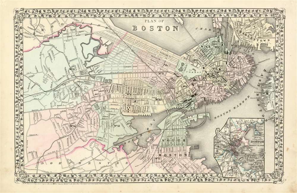
Plan of Boston.
1870 (dated) 13.25 x 20.75 in (33.655 x 52.705 cm) 1 : 16000
1870 (dated) 13.25 x 20.75 in (33.655 x 52.705 cm) 1 : 16000
Description
A beautiful example of S. A. Mitchell Jr.'s newly-expanded 1870 map of Boston, Massachusetts. While Mitchell's 1860's plans of Boston extend only as far west as Dartmouth Street, this new map covers as far west as Brookline and as far south as Dorchester. The map is sharply detailed, with special focus on railroads and terminal buildings. Some prospective streets - Atlantic Avenue, in particular - are shown, prior to the placement of the landfill on which the street would be built. An inset in the lower right quadrant depicts Boston Harbor and the surrounding counties of Essex, Middlesex and Nortfolk . Features the vine motif border typical of Mitchell maps from the 1866 - 1882 period.
Publication History and Census
Prepared by S. A. Mitchell for inclusion as plate no. 16 in the 1870 issue of Mitchell's New General Atlas. Dated and copyrighted, 'Entered according to Act of Congress in the Year 1870 by S. A. Mitchell in the Office of the Librarian of Congress at Washington.' While various editions of this map are not uncommon on the market, this edition appears to be scarce; only two examples are listed in institutional collections by OCLC.Cartographer
Samuel Augustus Mitchell (March 20, 1792 - December 20, 1868) began his map publishing career in the early 1830s. Mitchell was born in Bristol, Connecticut. He relocated to Philadelphia in 1821. Having worked as a school teacher and a geographical writer, Mitchell was frustrated with the low quality and inaccuracy of school texts of the period. His first maps were an attempt to rectify this problem. In the next 20 years Mitchell would become the most prominent American map publisher of the mid-19th century. Mitchell worked with prominent engravers J. H. Young, H. S. Tanner, and H. N. Burroughs before attaining the full copyright on his maps in 1847. In 1849 Mitchell either partnered with or sold his plates to Thomas, Cowperthwait and Company who continued to publish the Mitchell's Universal Atlas. By about 1856 most of the Mitchell plates and copyrights were acquired by Charles Desilver who continued to publish the maps, many with modified borders and color schemes, until Mitchell's son, Samuel Augustus Mitchell Junior, entered the picture. In 1859, S.A. Mitchell Jr. purchased most of the plates back from Desilver and introduced his own floral motif border. From 1860 on, he published his own editions of the New General Atlas. The younger Mitchell became as prominent as his father, publishing maps and atlases until 1887, when most of the copyrights were again sold and the Mitchell firm closed its doors for the final time. More by this mapmaker...
Source
Mitchell, S. A., Jr., Mitchell's New General Atlas, (1867 Edition).
Condition
Very good condition.
References
Phillips (Atlases) 831-16. OCLC 55943950.