This item has been sold, but you can get on the Waitlist to be notified if another example becomes available, or purchase a digital scan.
1778 Robson Map of Boston and the Battle of Bunker Hill
Boston-robson-1778$750.00

Title
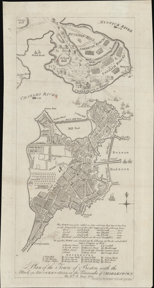
Plan of the Town of Boston with the Attack on Bunkers-Hill in the Peninsula of Charlestown, the 17th of June 1775.
1778 (dated) 12 x 6 in (30.48 x 15.24 cm) 1 : 19000
1778 (dated) 12 x 6 in (30.48 x 15.24 cm) 1 : 19000
Description
This is a 1778 map of the American Revolutionary War Battle of Bunker's Hill, Charleston and Boston, Massachusetts, engraved by T. Robson for the British edition of James Murray's Impartial History of the Present War in America.
British-controlled Boston is to the south. A large encampment of British Regulars is illustrated on the Common. Streets are labeled throughout, many of which still exist. At the bottom right is a chronology of the 10 fires that devastated Boston between 1653 and 1760, a list of the 12 wards, and an alphabetical key to twelve significant sites, including the Town Hall, Faneuil Hall, the Customs House, Trinity Church, the Old Meeting House, and more.
A Closer Look
Coverage embraces two peninsulas, the Shawmut Peninsula containing Boston, and the Charleston Peninsula, containing Charleston and most of the military action presented here. Charleston itself is aflame. Bunker's Hill is labeled, but nearby Breeds Hill, where the battle occurred, is only illustrated. Continental and British forces are shown in neat ranks, emphasizing the numerical and artillery disadvantage of the Continental force despite holding the high ground. Charleston suffers additional bombardment from British ships on the Charles River and a battery on Corps Hill in Boston.British-controlled Boston is to the south. A large encampment of British Regulars is illustrated on the Common. Streets are labeled throughout, many of which still exist. At the bottom right is a chronology of the 10 fires that devastated Boston between 1653 and 1760, a list of the 12 wards, and an alphabetical key to twelve significant sites, including the Town Hall, Faneuil Hall, the Customs House, Trinity Church, the Old Meeting House, and more.
Battle of Bunker Hill
The Battle of Bunker Hill, fought on June 17, 1775, during the early stages of the American Revolutionary War (1775 - 1783), was a pivotal confrontation between the colonial forces of the newly formed Continental Army and the British Army. Despite its name, most of the fighting actually occurred on nearby Breed's Hill - here unlabeled but the site of a redoubt at the center of the Charleston Peninsula. The battle was significant, marking the first major military engagement between the British and colonial forces. Although the British ultimately claimed victory, their success came at a high cost, with significant casualties. The battle demonstrated the determination and fighting spirit of the colonial forces and served as a rallying cry for American independence, inspiring further resistance against British rule.Publication History and Census
This image is derived from an inset map in Sayer and Bennet's 1775 map, The Seat of War in New England. It was adapted and published in London by Thomas Robson in 1778 for James Murray's Impartial History of the Present War in America, corresponding to this example. A third variant was engraved by John Norman for the American edition of Murray's work and can command upwards of 9k at auction. Examples of the London edition of Murray's work were published from 1779 - 1784, all contained this map, but it is impossible to distinguish the separate maps between printings. Nonetheless, all examples are rare.Cartographer
Thomas Robson (fl. c. 1775 - 1788) was a British engraver and publisher active in Newcastle upon Tyne in the late 1700s. Robson is best known for his portraiture and engraving for James Murray's Impartial History of the Present War in America. From 1775 - 1776, he traded in partnership with Thomas Angus Sr. as alternatively 'Robson and Angus' or 'Angus, Robson and Co.' After 1776, he was independently as 'Robson and Co.' Notably, he is not the Thomas Robson that was active in Sunderland from c. 1808 - 1861. More by this mapmaker...
Source
Murray, James, Impartial History of the Present War in America, (Newcastle upon Tyne: T. Robson) 1779 - 1784.
Condition
Good. Some soiling. Minor verso repair of old closed fold split extending about 1 inch into the map.
References
Library of Congress #G3764.B6S3 1778 .R6. Boston Public Library, Leventhal, G3764.B6S3 1778.P5.