This item has been sold, but you can get on the Waitlist to be notified if another example becomes available, or purchase a digital scan.
1842 S.D.U.K. City Map or Plan of Boston, Massachusetts
Boston-sduk-1842$200.00

Title
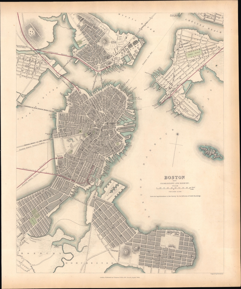
Boston with Charlestown and Roxbury.
1842 (dated) 15 x 11.75 in (38.1 x 29.845 cm) 1 : 16500
1842 (dated) 15 x 11.75 in (38.1 x 29.845 cm) 1 : 16500
Description
This is an 1842 Society for the Diffusion of Useful Knowledge (S.D.U.K.) map of Boston. It provides a snapshot of the city in transition, in the early days of the railroad boom, but before much of the landfill that would give Boston its modern form.
A Closer Look
The map shows the city from Charlestown and the Chelsea Reach in the north, down to Dorchester and South Boston; the map reaches as far west as Lechmere and part of Roxbury and as far east as roughly the intersection of Chelsea and East Eagle streets. Bird Island appears in the harbor with the notation indicating that it is underwater at high tide. Forts, municipal structures, and factories are marked, as are gardens and commons. Multiple rail lines, including proposed extensions, are noted, along with depots, providing a look at the early rail infrastructure of Boston. Much of the water seen here would be filled in over the following decades to provide additional land for the growing city, including what would become South Boston and the Back Bay.The Back Bay
The tracks of the Worcester and the Boston and Providence Railways are shown running on causeways through the Back Bay, which was not yet filled and is labeled Mill Pond. The Boston and Roxbury Mill Dam is shown; this had been intended to enclose the Back Bay and utilize the flowing tidal waters for industrial production. While it succeeded in the enclosure of the bay, doing so caused the body of water to become stagnant and foul. Moreover, only a fraction of the factories the dam was intended to power came to be constructed. Thus, failing on several fronts, the dam would persist until 1857, when the plan to fill in the Back Bay was commissioned.Publication History and Census
The map was engraved by Benjamin Reese Davies and added to Maps of the Society for the Diffusion of Useful Knowledge. Vol. 1, published by Chapman and Hall in 1844. The OCLC commingles multiple editions of the map as well as digital and physical examples, but this edition of the physical map is independently cataloged among the holdings of the Boston Public Library (Leventhal), the New York Public Library, and Western University. The David Rumsey Historical Map Collection also catalogs an example as part of the larger Maps… publication.CartographerS
The "Society for the Diffusion of Useful Knowledge" (1826 - 1848) was a Whiggish organization founded in 1828 at the instigation of idealistic British lord Henry Peter Brougham. The admirable goal of the Society was to distribute useful information via a series of publications to the English working and middle classes. It promoted self-education and the egalitarian sharing of all knowledge. While closely tied to the London University and publishing houses on the order of Baldwin and Cradock, Chapman and Hall, and Charles Knight, the Society failed to achieve its many lofty goals in finally closed its doors in 1848. Most likely the failure of the Society resulted from its publications being too expensive for its intended lower to middle class markets and yet not large and fine enough to appeal to the aristocratic market. Nonetheless, it did manage to publish several extraordinary atlases of impressive detail and sophistication. Their most prominent atlas consisted of some 200 separately issued maps initially published by Baldwin and Cradock and sold by subscription from 1829 to 1844. Afterwards, the Society combined the maps into a single world atlas published under the Chapman and Hall imprint. In its day, this atlas was unprecedented in its quality, scope, and cost effectiveness. Today Society, or S.D.U.K. as it is commonly known, maps are among the most impressive examples of mid-19th century English mass market cartographic publishing available. The S.D.U.K. is especially known for its beautiful and accurately detailed city plans. More by this mapmaker...
Benjamin Rees Davies (1789 - December 16, 1872) was an engraver, cartographer, painter, and map publisher active in the early to mid-19th century. Davies was born in Holborn, England, apprenticed as under John Lodge in 1803. He began publishing around 1811 and is known to have compiled many of own maps from original survey work. From approximately 1848 onward Davies published in conjunction with the Stanford Firm. He is also known to have engraved a number of maps for the Dispatch Atlas and the S.D.U.K. Davies was an early adopter of steel plate engraving and used the exceptional hardness of steel to create some of the most delicately engraved and beautifully produced maps of his era. He was quite famous in England for his detailed street plans of London, which he began publishing in 1848. Davies is known to have worked with numerous other cartographers of his period including French, Mexican, and American map makers. Many of his maps and plans continued to be published and updated posthumously well into the 1880s. Learn More...
Source
S. D. U. K, Maps of the Society for the Diffusion of Useful Knowledge, (London: Knight) 1842.
The Society for the Diffusion of Useful Knowledge (S.D.U.K.) Atlas was initially issued in parts over several years by Baldwin and Craddock to promote the society's mission of egalitarian self-education. The first S.D.U.K. began appearing in 1829 when the society contracted John Walker to produce the first proofs. The first S.D.U.K maps were produced serially by Baldwin and Craddock and issued in 2 map batches, priced at 2 shillings each. The series, originally anticipated to feature 50 maps, ultimately contained 200 and took over 14 years to produce. The initial production was completed in 1844 when the whole was issued in its first compiled atlas edition. Around 1842, following the 1837 bankruptcy of Baldwin and Craddock, publication of the atlas was taken over by the Society itself, who issued editions in 1838, 1839, 1840, 1841, and 1842. Overburdened by the work of publishing, they then outsourced the publication to Chapman and Hall in 1842. Chapman and Hall produced editions in 1842, 1843, and 1844. Dissatisfied with the quality of Chapman and Hall printing, the Society turned to another publisher, Charles Knight, who issued editions under the auspices of the Society in 1844, 1845, and 1846. In 1846 Knight officially acquired the plates in his own right and reissued in revised editions until 1852, when he sold them to George Cox. Cox in turn sold them to Edward Stanford who published them from 1856 well into the 1860s. The S.D.U.K. Atlas is known for the quantity and quality of its maps. The S.D.U.K. published many maps of areas largely ignored by other publishers. The many city plans incorporated into the atlas are particularly admired and are the highlight of the S.D.U.K.'s long map publishing history. As a whole the S.D.U.K. Atlas was groundbreaking in terms of quality, scope, and being offer at a cost effective price point.
Condition
Very good. Slightly uneven toning in margins.
References
Rumsey 0890.166. Leventhal 06_01_004794. OCLC 317749715.