This item has been sold, but you can get on the Waitlist to be notified if another example becomes available, or purchase a digital scan.
1905 Walker Map or Plan of the City of Boston, Massachusetts
Boston-walker-1905$87.50

Title
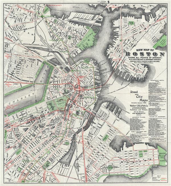
New Map of Boston Giving All Points of Interest : With Every Railway and Steamboat Terminus, Prominent Hotels Theatres and Public Buildings.
1905 (undated) 19 x 17.5 in (48.26 x 44.45 cm) 1 : 13000
1905 (undated) 19 x 17.5 in (48.26 x 44.45 cm) 1 : 13000
Description
This is a beautiful 1905 map or plan of the city of Boston, Massachusetts by the Walker Lithograph and Publishing Company. It covers the city of Boston from Charlestown and Somerville to Marine Park and Old Harbor. Individual streets, important buildings, neighborhoods, parks, piers, railway and ferry lines, subway lines and other topographical features are identified. An index of historical places, public buildings and offices, noteworthy institutions, clubs, places of amusement and railroad stations is included along the right margin.
Though undated, the development of the East Boston Tunnel suggests that this map was created in 1905. The East Boston Tunnel opened in 1904, making it the first subway in the world to run under a section of the ocean. The Atlantic Station, opened in 1906, is not marked on this map, suggesting that this map was created between 1904 and 1906. This map was issued by the Walker Lithograph and Publishing Co., 400 Newbury St., Boston.
Though undated, the development of the East Boston Tunnel suggests that this map was created in 1905. The East Boston Tunnel opened in 1904, making it the first subway in the world to run under a section of the ocean. The Atlantic Station, opened in 1906, is not marked on this map, suggesting that this map was created between 1904 and 1906. This map was issued by the Walker Lithograph and Publishing Co., 400 Newbury St., Boston.
Cartographer
George Hiram Walker (January 4, 1852 - November 14, 1927) was a Boston based publisher of books, views, and maps active in the late 19th and early 20th centuries. Born in Springfield, Vermont, Walker started his life as a dry goods merchant but developed an active interest in publishing during the early 1870s. Walker began publishing in 1878 when he partnered with an unknown New York Firm. Two years later, Walker brought the operation in house by partnering with his brother, Oscar W. Walker, in the opening of a lithography studio at 81 Milk Street, Boston. Shortly thereafter the firm expanded to new offices at 160 Tremont Street, Boston. The Walker brothers produced a large corpus of works, most of which focused on travel and tourism in New England. Walker also established the Walker-Gordon Milk Laboratory with Dr. Thomas Morgan Rotch and Gustave Gordon. This interesting investment was based on the premise that infant deaths could be avoided by providing higher quality milk. The company eventually became a great success, producing a high-quality cow milk that closely resembled human breast milk. In the process the Walker-Gordon laboratory developed many of the dairy health standards that are still with us today. Walker married Irene L. Loud on March 25, 1885. More by this mapmaker...
Condition
Very good. Minor wear along original fold lines. Professionally flattened and backed with archival tissue. Accompanied by original cover.