This item has been sold, but you can get on the Waitlist to be notified if another example becomes available, or purchase a digital scan.
1851 John Tallis Map of Boston, Massachusetts
Boston2-tallis-1851$200.00

Title
Boston.
1851 (undated) 10 x 13 in (25.4 x 33.02 cm) 1 : 14400
1851 (undated) 10 x 13 in (25.4 x 33.02 cm) 1 : 14400
Description
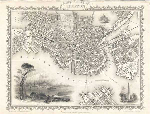
A beautiful example of John Tallis’ and John Rapkin's 1851 decorative map of Boston, Massachusetts. The map covers downtown Boston prior to the Back Bay landfill projects, extending from Dover Street to the Charles River. Parts of adjacent South Boston, Cambridge, and Charleston are also included. The map identifies all streets, piers, parks, and important buildings. A beautifully engraved and dramatic vignette view of Boston from across Boston Harbor appears in the lower left quadrant. A secondary vignette, depicting the Bunker Hill Monument, appears in the lower right. A tertiary vignette, in the upper right between Cambridge and Boston proper, illustrates the State House. The map is surrounded by an elaborate decorative border. Tallis' city plans did not appear in all editions of his atlas and so have become quite rare. Tallis prepared this map for inclusion in R. Montgomery Martin's Illustrated Atlas, and Modern History of the World.
Cartographer
John Tallis and Company (1838 - 1851) published views, maps, and atlases in London from roughly 1838 to 1851. Their principal works, expanding upon the earlier maps of John Cary and Aaron Arrowsmith, include an 1838 collection of London Street Views and the 1849 Illustrated Atlas of the World. The firm’s primary engraver was John Rapkin, whose name and decorative vignettes appear on most Tallis maps. Due to the embellishments typical of Rapkin's work, many regard Tallis maps as the last bastion of English decorative cartography in the 19th century. Although most Tallis maps were originally issued uncolored, it was not uncommon for 19th century libraries to commission colorists to "complete" the atlas. The London Printing and Publishing Company of London and New York bought the rights for many Tallis maps in 1850 and continued issuing his Illustrated Atlas of the World until the mid-1850s. Specific Tallis maps later appeared in innumerable mid to late-19th century publications as illustrations and appendices. More by this mapmaker...
Source
Montgomery Martin, R., The Illustrated Atlas, And Modern History Of The World, (London) 1851.
Condition
Very good. Minor spotting.
References
OCLC 316615883.