This item has been sold, but you can get on the Waitlist to be notified if another example becomes available, or purchase a digital scan.
1936 Wallingford Map : A Bostonian's View of the United States
BostoniansView-wallingford-1936$200.00

Title
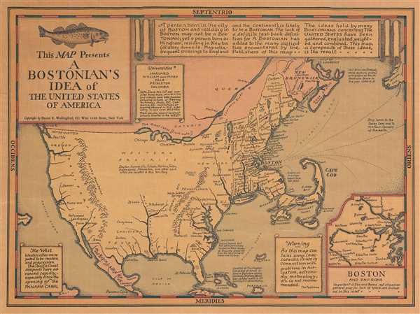
This Map Presents A Bostonian's Idea of the United States of America.
1936 (undated) 11.75 x 16 in (29.845 x 40.64 cm)
1936 (undated) 11.75 x 16 in (29.845 x 40.64 cm)
Description
This is a 1936 Daniel Wallingford map of the United States as viewed by the stereotypical Bostonian. Poking fun at the caricaturized idea of a Bostonian, the map depicts the country varying detail, with a high degree of accuracy and numerous cities and towns labeled in the Northeast and decreasing accuracy and density of cities and towns further to the west. In other words, further away from the part of the world that the 'Bostonian' knows and cares about. For example, in the 'western prairies' the cities are listed, but not placed anywhere. They are just said to be 'located in this territory'. The Mississippi River barely reaches half way up the country from New Orleans, while Denver and Omaha are both decidedly West Coast cities. As a point of caution, the publishers have included a warning, 'As this map contains some inaccuracies, its use in connection with problems in navigation, astronomy, meteorology, etc. is not recommended.' An inset map of Boston and its environs is located in the lower right corner, with 'important cities and towns not shown on general map for lack of space are included in this inset.' It is also of note that Bali is no longer located in Indonesia, but just off the coast of Central America, per this map.
This map was published by Daniel Wallingford in 1936. There are three versions of this map bearing different locations of publication: New York (like the current example), Boston, and Chicago.
This map was published by Daniel Wallingford in 1936. There are three versions of this map bearing different locations of publication: New York (like the current example), Boston, and Chicago.
Cartographer
Daniel Kirkwood Wallingford (September 12, 1890 – January 11, 1964) was an American industrial designer and artist. He was born in St. Paul, Minnesota, the son of an architect. Wallingford, first came to national attention as a schoolboy in Indianapolis, when he was so moved by the 1898 explosion of the battleship Maine, off Cuba, that he he donated his life savings of 49 cents to the Dept. of the Navy with a note reading, 'I saved the money myself. I got part of it for having my tooth pulled and I save part of it from Christmas ... I wanted to help build a ship'. For his patriotism a steel-sheathed tugboat was named after him. Wallingford went on to attend Phillips Andover Academy, then Cornell University where studied Architecture and Industrial Design and was a member of the Sigma Chi Fraternity. From 1917 - 1919, he served in World War I (1914 - 1818) and as Lieutenant Colonel of Artillery in World War II (1939 - 1945). He is known for two important maps, New Yorker's View of the United States of America and The Bostonian's View of the United States of America. Both maps were revolutionary in the evolution of the American pictorial map for their satirical depiction of New York and Boston, respectively. The New Yorker's View, Wallingford's first map, was initially issued in 1932 in just 100 prints, which Wallingford distributed as Christmas gifts. The map proved so popular he revised it and proceed a second edition in 1935. Later, in March of 1976, a modified version appeared as a New Yorker cover. Shortly after moving to Boston in 1936, he issued his second map, the The Bostonian's View, also sold via mail order. A third less famous map, A Bookman's Idea of the United States was published in 1938. Wallingford was most likely inspired by John T. McCutcheon's 1922 New Yorker's View of the World and intern inspired a number of subsequent artists including John Roman (Cowboy America) and Ernest Dudley Chase (The United States as Viewed by California). Despite the near iconic popularity of his two famous maps, little is known of Wallingford's personal life. Wallingford died in 1964 and was survived by his wife, Margaret. More by this mapmaker...
Condition
Very good. Varnished. Blank on verso.
References
Rumsey 8203.000.