This item has been sold, but you can get on the Waitlist to be notified if another example becomes available, or purchase a digital scan.
1692 Jaillot Map of Burgundy and Franche Comte, France (Burgundy Wine)
Bourgogne-jaillot-1692$325.00

Title
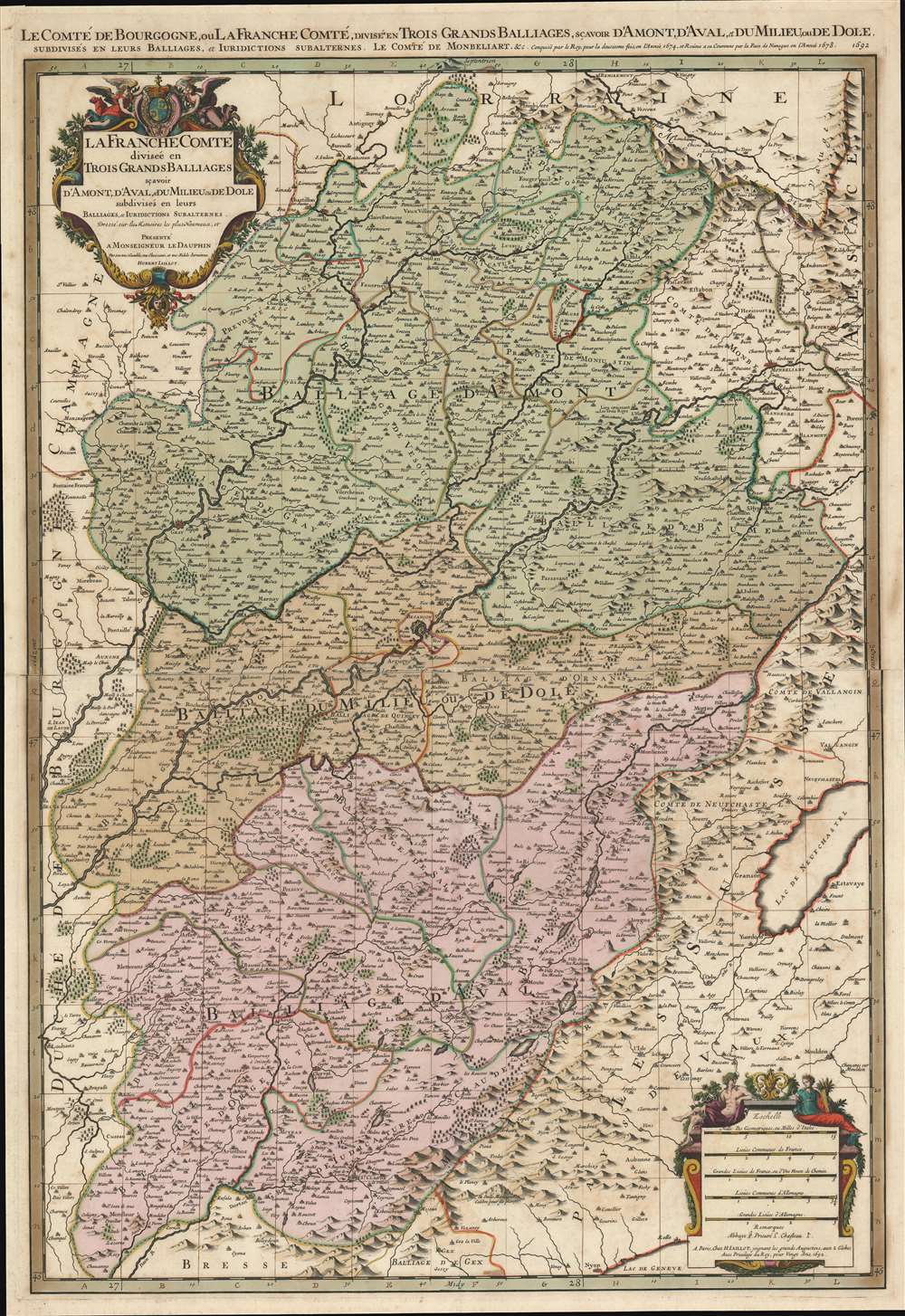
Le Comté de Bourgogne, ou La Franche Comté, Divisée en Trois Grands Balliages, Scavoir d'Amont, d'Aval, et du Milieu, ou de Dole, Subdivisés en Leurs Balliages, et Jurisdictions Subalternes.
1692 (dated) 32.5 x 22.25 in (82.55 x 56.515 cm) 1 : 320000
1692 (dated) 32.5 x 22.25 in (82.55 x 56.515 cm) 1 : 320000
Description
This is a 1692 Alexis-Hubert Jaillot map of Burgundy and Franche-Comté, France. Beautifully engraved and hand colored, myriad cities, towns, and villages are labeled throughout the region, including Besançon, Dole, Vesoul, and Belfort. The Doubs, Saone, and Lougnon Rivers are illustrated and labeled as well. A wonderful title cartouche adorns the upper left corner and a second cartouche on the lower right contains the map's scales.
Wine and Cheese
Two of Franche-Comté's most well-known products are yellow wine (vin jaune) and comté cheese. Vin jaune is a specialty of the Jura region and is a special type of white wine. It resembles a dry Sherry, and even has some similar characteristics, including its aroma, but vin jaune is not a fortified wine. A festival called La Percée du Vin Jaune takes place annually during the last week of January or the first week of February and celebrates the release of the most recent vintage (which would have been harvested seven years earlier). The festival is held in a different village every year, and in recent years it has attracted over 30,000 visitors. Comté is also a specialty of Franche-Comté and is made from unpasteurized cow's milk.Burgundy or Franche-Comté?
Historically, Franche-Comté was part of Burgundy, and over the centuries has either been part of Burgundy or has been its own independent province. Today, the region is known as Bourgogne-Franche-Comté after Burgundy and Franche-Comté were merged on January 1, 2016.Publication History and Census
This map was created by Alexis-Hubert Jaillot and published in 1692. Eleven examples are cataloged in OCLC and are almost exclusively part of European institutional collections, including at the Bibliothèque nationale de France, the Bayerische Staatsbibliothek in Munich, the Deutches Museum Bibliothek in Munich, the Universitätsbibliothek Bern, and the Landesbibliothek Coburg.Cartographer
Alexis-Hubert Jaillot (c. 1632 - 1712) followed Nicholas Sanson (1600 - 1667) and his descendants in ushering in the great age of French Cartography in the late 17th and 18th century. The publishing center of the cartographic world gradually transitioned from Amsterdam to Paris following the disastrous inferno that destroyed the preeminent Blaeu firm in 1672. Hubert Jaillot was born in Franche-Comte and trained as a sculptor. When he married the daughter of the Enlumineur de la Reine, Nicholas I Berey (1610 - 1665), he found himself positioned to inherit a lucrative map and print publishing firm. When Nicholas Sanson, the premier French cartographer of the day, died, Jaillot negotiated with his heirs, particularly Guillaume Sanson (1633 - 1703), to republish much of Sanson's work. Though not a cartographer himself, Jaillot's access to the Sanson plates enabled him to publish numerous maps and atlases with only slight modifications and updates to the plates. As a sculptor and an artist, Jaillot's maps were particularly admired for their elaborate and meaningful allegorical cartouches and other decorative elements. Jaillot used his allegorical cartouche work to extol the virtues of the Sun King Louis IV, and his military and political triumphs. These earned him the patronage of the French crown who used his maps in the tutoring of the young Dauphin. In 1686, he was awarded the title of Geographe du Roi, bearing with it significant prestige and the yearly stipend of 600 Livres. Jaillot was one of the last French map makers to acquire this title. Louis XV, after taking the throne, replaced the position with the more prestigious and singular title of Premier Geographe du Roi. Jaillot died in Paris in 1712. His most important work was his 1693 Le Neptune Francois. Jalliot was succeeded by his son, Bernard-Jean-Hyacinthe Jaillot (1673 - 1739), grandson, Bernard-Antoine Jaillot (???? – 1749), and the latter's brother-in-law, Jean Baptiste-Michel Renou de Chauvigné-Jaillot (1710 - 1780). More by this mapmaker...
Condition
Very good. Exhibits light wear along original centerfold. Centerfold reinforcement on verso. Two small areas of infill along original centerfold. Blank on verso.
References
OCLC 494782005.