This item has been sold, but you can get on the Waitlist to be notified if another example becomes available, or purchase a digital scan.
1819 Norie Nautical Chart or Map of Brazil
Brazil-norie-1811$1,250.00

Title
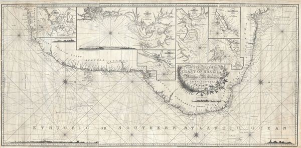
A New Chart of the Coast of Brazil from Maranham to Rio Janeiro.
1819 (dated) 26 x 52 in (66.04 x 132.08 cm)
1819 (dated) 26 x 52 in (66.04 x 132.08 cm)
Description
An extraordinary 1819 John Norie nautical chart or portolan map of the coast of Brazil. This fantastic map, a quintessential example of early 19th century British chart making, covers the eastern coastline of South America from the mouth of the Amazon River at Maranhao (Maranham) to Rio de Janeiro. The chart is beautifully detailed with countless depth soundings along the coastlines as well as an elaborate network of rhumb lines throughout. The chart features six inset sub-maps detailing, from left, the harbor of Rio de Janeiro, the Bay of All Saints (Baía de Todos os Santos, Bahia, Brazil), the road of Pernambuco, the Bay of St. Marcos (mouth of the Amazon), the exceptionally beautiful islands of Fernando de Noronha (one of Darwin's stopping places on the Beagle), and the entrance to St Louis of Maranham (Sao, Luis, Maranhao). The chart additionally offers five land profiles to aid navigators in identifying important landmarks. A large decorative agriculturally themed title cartouche appears at bottom center.
Shortly before this chart was issued Brazil rose to greater significance as the seat of the Portuguese court in exile. King Joao VI, fleeing Napoleon's invasion of Portugal during the Peninsular War, reestablished his monarchy in the colonial seat of Rio de Janeiro. The monarchy's presence in Brazil would have a lasting impact on the colony. In 1821, following the stabilization of europe after Napoleon's defeat, Joao VI returned to Portugal leaving his eldest son, Pedro, as regent of Brazil. Within one year Pedro declared Brazil independent, instituted a constitutional monarchy, and established himself at its head, emperor Pedro I of Brazil.
Noire first compiled this chart under William Heather, whose copyright appears below the bottom left border, in 1810. The present example has been updated to 'a new edition' in 1819 - shortly after Heather's death and Norie and Wilson's takeover of the firm. This map is extremely scarce with only one other example appearing in the OCLC. We suspect that this chart may have had a very small run, as Norie replaced it with a series of more specific charts of the Brazil coastline in the 1820s and 30s.
CartographerS
John William Norie (June 3, 1772 - December 24, 1843) was a British teacher of navigation, hydrographer, chart maker, and publisher of maritime manuals active in London, England in the late 18th and early 19th centuries. Norie was born in Wapping, London, an area long associated with the maritime sciences. Norie's career as a chart maker commenced under the tutelage of William Heather, a prominent purveyor and publisher of nautical charts, pilot books, and navigational tools who took over the firm of Mount and Page in 1765. Heather and Norie were likely acquainted through John Hamilton Moore, another important chart maker with whom both seem to have been associated early in their careers. Heather hired Norie to teach basic navigation at his shop at 157 Leadenhall Street. Under Heather Norie also distinguished himself as a draftsman, completing many of the early charts associated with the Heather firm. When Heather died in 1812 John Norie partnered with George Wilson, a moneyed 'man about town' with little experience in the maritime trades, to acquire the map and chart business at 9500 British Pounds. It proved a good deal for Norie, who retained all copyright privileges and drew 1/4 quarter share of business profits, as well an impressive quarterly salary and, for doing all of the work, 1/3rd of Wilson's share. The firm, referred to as the 'Naval Warehouse' quickly acquired a reputation for quality navigational materials and became a favorite of merchant seamen. It was even referenced in Charles Dickens' classic novel Dombey and Son. In 1819, Norie and Wilson acquired the failing chart business of David Steel, which significantly increased the size, though not quality, of their chart catalogue. With the rise of the British Admiralty and its own maritime chart productions, the business of "Chart Purveyor" in London dramatically changed. Admiralty charts and pilot books, designed for military use, were offered through established intermediaries, like Norie, at bargain prices. Most chart makers of the period found it profitable to use the highly technical Admiralty charts to update their own more decorative vernacular charts. For a brief time this practice proved exceptionally profitable but eventually began to draw criticism. Nonetheless, Norie retired to Edinburgh in 1840 and died a wealthy man in 1843. In 1840 the business passed to a nephew of George Wilson, Charles Wilson, who renamed the firm "Norie & Wilson". William Heather Norie, J. W. Norie's own son, produced few charts, instead pursuing a career in the legal field. Norie & Wilson merged with James Imray's prosperous chart business in 1899, becoming Imray, Laurie, Norie & Wilson, a profitable concern that remains active in the maritime charting industry. More by this mapmaker...
John Stephenson (fl. c. 1790 - 1836) was a British engraver active in the London nautical chart trade in the late 19th and early 19th century. There is some speculation by Lawrence Worms, Baynton-Williams, and other map scholars, that Stephenson apprenticed with the stationer Charles John Downes. Stephenson engraved for the nautical chart firm of John Hamilton Moore until 1793, when he moved on to the firm of William Heather. Heather's firm was subsequently inherited, along with Stephenson, by John William Noire. Stephenson's characteristic style, involving strong lines, elaborate typographic embellishment, and finely-engraved detail, it is commonly associated with John Noire. Learn More...
Condition
Very good. A working nautical chart, some pencil marks and soiling related to navigational use. Professionally cleaned and backed with fresh linen.