This item has been sold, but you can get on the Waitlist to be notified if another example becomes available, or purchase a digital scan.
1847 Blachford Blueback Nautical Chart of Map of South Brazil
BrazilSouth-balchford-1847$450.00

Title
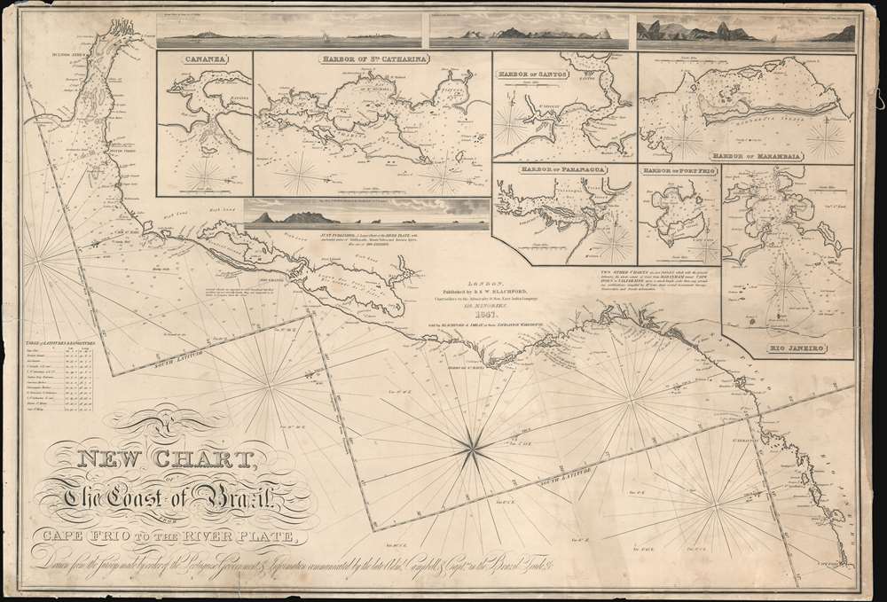
A New Chart, The Coast of Brazil, Cape Frio to the River Plate.
1847 (dated) 25.5 x 39 in (64.77 x 99.06 cm) 1 : 2040000
1847 (dated) 25.5 x 39 in (64.77 x 99.06 cm) 1 : 2040000
Description
A very rare 1847 Robert Blachford blueback nautical chart or maritime map of the Coast of Brazil from the Rio de la Plata (Buenos Aires) to Rio de Janeiro. The chart includes four profile recognition views and seven inset charts including: Rio Janeiro; Harbor of Marambaia; Harbor of Port Frio; Harbor of Paranagua; Harbor of Santos; Harbor of St. Catharina; and Cananea. The cartography is attributed to Rear-Admiral Donald Campbell (1752 - 1819), briefly commandant of the Brazilian squadron of the Portuguese navy during the early 19th century. Campbell, although Scottish, was in the employ of the Portuguese Navy, as the British had interest in defending the Brazil trade against possible French attack during the transition of the Portuguese monarchy to the New World.
Blueback Charts
Blueback nautical charts began appearing in London in the late 18th century. Bluebacks, as they came to be called, were privately published large format nautical charts known for their distinctive blue paper backing. The backing, a commonly available blue manila paper traditionally used by publishers to warp unbound pamphlets, was adopted as a practical way to reinforce the low-quality paper used by private chart publishers in an effort to cut costs. The earliest known blueback charts include a 1760 chart issued by Mount and Page, and a 1787 chart issued by Robert Sayer. The tradition took off in the early 19th century, when British publishers like John Hamilton Moore, Robert Blachford, James Imray, William Heather, John William Norie, Charles Wilson, David Steel, R. H. Laurie, and John Hobbs, among others, rose to dominate the chart trade. Bluebacks became so popular that the convention was embraced by chartmakers outside of England, including Americans Edmund March Blunt and George Eldridge, as well as Scandinavian, French, German, Russian, and Spanish chartmakers. Blueback charts remained popular until the late 19th century, when government subsidized organizations like the British Admiralty Hydrographic Office and the United States Coast Survey, began issuing their own superior charts on high quality paper that did not require reinforcement.Publication History and Census
This map was first issued in 1835. The present example is the 1847 reissue, distinguished by the 'Sold by Blachford and Imray, at their Navigation Warehouse' inscription under the R. and W. Blachford imprint. All examples are extremely rare with no examples cited in the OCLC and only one other known in private hands.Cartographer
Robert Blachford (1775 - c. 1852) was an Irish maker of blueback nautical charts active in the middle part of the 19th century. Compared with many major nautical chart publishers in London, little is known of Blachford. Around 1802 he married Elizabeth Moore, the daughter of the John Hamilton Moore (1738 - 1807), a prolific producer of navigational textbooks and nautical charts. Blachford must have been introduced to nautical chart making by Moore, but his partnership with the latter was short-lived and dissolved two years later in 1804. By 1805, Blachford had established his own firm located at 137 Minories, London. Initially, Blachford's business seems to have been poor and he produced charts only sporadically until about 1808, when he opened a new shop at 114 Minories. From this location he published about 20 - 30 known charts primarily focusing on the North Sea and the Baltic. Most of these were based on Moore's earlier work but fully re-engraved by Samuel Stockley (who also, incidentally, engraved for William Heather). With such a meager publication history, it is unsurprising that Blachford declared bankruptcy in May of 1819. Shortly thereafter Blachford was back in business and partnered with William Lane. This partnership was also short-lived, issuing about 15 charts before being dissolved in 1821. Around 1827 Blachford again reappeared, this time at his old stomping ground Minories (116), an office he would maintain for the next 25 years. Robert this time partnered with William Blachford, presumably a relative though the relationship is unclear. The firm issued numerous charts focused on the British coastal trade. The rough and damp conditions synonymous with this trade determined that few Blachford charts from this period would survived. Around 1835 Robert and William Blachford retired, passing the business on to Michael Blachford (1807 - 1889), who partnered with the stationer and draftsman James Imray. The Imray-Blachford partnership proved potent. Athough new to the field of chart making, Imray was hard working, intelligent, and ambitious. By 1846, Imray had bought out Michael Blachford and was on the rise to being the largest and most prominent maker of nautical charts in history. More by this mapmaker...
Condition
Good. Working nautical chart exhibits soiling and damage associated with use at sea. Blueblack. Some older repairs to large tear from right. More contemporary verso reinforcements to smaller tear from left and minor separation, bottom hear title.