This item has been sold, but you can get on the Waitlist to be notified if another example becomes available, or purchase a digital scan.
1940 Detroit News Pictorial Map of the Possible Nazi Attack on Britain
BritainsHope-detroitnews-1940$187.50

Title
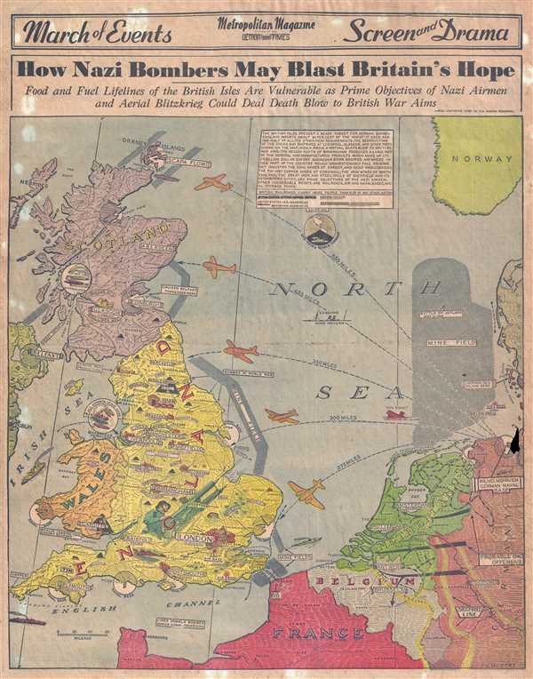
How Nazi Bombers May Blast Britain's Hope.
1940 (dated) 20 x 16 in (50.8 x 40.64 cm) 1 : 2550000
1940 (dated) 20 x 16 in (50.8 x 40.64 cm) 1 : 2550000
Description
This is a 1940 Detroit News Metropolitan Magazine pictorial map of England, Scotland, Wales, and the northern coast of Europe. The map depicts the region from Belfast, Ireland to Norway and from the Orkney Islands to France, Belgium, the Netherlands, and Germany. Printed in April 1940, this map predates the Nazi spring offensive of that year, which did not begin until May. Thus, everything illustrated here was a presumption of Hitler's next move. The distances provided clearly indicate that targets throughout England and Scotland fell well within the range of German bombers based in Germany, creating 'a ready target for German bombs.' Some of the presumed targets are labeled as having been bombed in the 'World War', meaning the Great War which ended less than two decades prior.
Highly detailed and extremely graphic, the focal point is an English civil defenseman manning an antiaircraft gun against the coming onslaught. Numerous cities in England, Scotland, and Wales are labeled, including London (with a nice profile illustration of St. Paul's Cathedral), Birmingham, Liverpool, Edinburgh, Glasgow, and Cardiff. Natural resources found on the British Isles, such are wheat, barley, iron, and coal are also labeled. Mine fields are illustrated along the eastern coast of England and between Dover and Calais, France.
Originally copyrighted by the Los Angeles Examiner, this map was printed by the Detroit News on Sunday, April 7, 1940. We have been unable to locate any other surviving examples.
Source
Detroit Times Sunday, April 7, 1945
Condition
Very good. Newsprint. Even overall toning. Loss along right margin along the northern coast of Germany. Text on verso.