1700 Wells Map of the British Possessions in North America
BritishColonies-wells-1700$1,200.00

Title
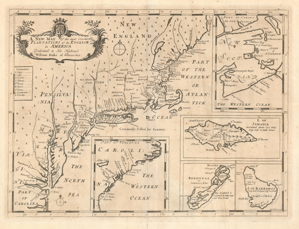
A New Map of the most considerable Plantations of the English in America.
1700 (undated) 14 x 18.75 in (35.56 x 47.625 cm) 1 : 3250000
1700 (undated) 14 x 18.75 in (35.56 x 47.625 cm) 1 : 3250000
Description
This is Edward Wells' 1700 map of the British colonies in North America, including insets of the islands of Bermuda, Barbados, and Jamaica.
A New Toponymy
It is one of only a few English maps of the colonies from this period. Of particular interest is the profusion of now-recognizable place names evident throughout. While Dutch and French maps of the 17th and early 18th centuries tended to give precedence to the names of the tribes with whom they intended to trade, the English in this region came with the intent to settle, and they brought their names along with them. New England, in particular, is rich in familiar names. By contrast, the colonies of New York and Pennsylvania show more trees than settlements and are evocative of the frontier.A Closer Look
Intended for academic use, the map is executed in a clear and simple style. The main map extends from North Carolina to the coast of Maine, showing 'Part of the Bay of Funda'. Additional inset maps focus on the Southeast (northern Florida to South Carolina), and 'New Scotland', which embraces Nova Scotia and New Brunswick up to the Saint Lawrence River. The inset of Jamaica illustrates the parishes and Port Royal. All three of the island insets include notes regarding the relative sizes of the islands, while the insets for Carolina and New Scotland employ latitude and longitude bars to differentiate scale from the main map.New Scotland, Halifax, and a Question of Date
This example is the rare third state as identified by Burden dating to c. 1743. This version of the map added a number of place names not present on earlier editions. Burden notes:Near New York, Perth is renamed Perth-Amboy. Kent (Island) is identified in Chesapeake Bay and the towns of Somerset, Guilford, Scarborough, Norfolk and nearby the Elizabeth R. are inserted. The Carolina inset now includes the town of London and the new colony of GEORGIA and its capital Savanna. The top right inset has added the GULPH of ST. LAURENCE and a nearby French Factory, Canso and Halifax(sic) are added and Port Royal renamed Annapolis Royal reflecting its English control. Port Royal, Jamaica, previously engraved rather tightly spaced on land is re-engraved offshore, and Cavendish F. and Harrington Sound are added to Bermuda.The appearance of 'Hallifax' on this third state does put Burden's dating in question, as that settlement was not founded and named until 1749. Institutional cataloging for the late editions of Wells' New Sett of Maps is inconsistent; we do see some dated as late as c. 1750. It is possible that the political backers for the Halifax colony had spread the idea around sufficiently for it to take hold in England prior to the colony's actual founding, but lacking concrete evidence, Occam's razor suggests a later date for the map as being more likely.
Publication History and Census
This map was prepared for inclusion in Wells' A new sett of maps both of ancient and present Geography in 1700; this student atlas was successful and stayed in publication for many years thereafter. This third state example is dated by Burden as c. 1743, although its content suggests a date after 1749.CartographerS
Edward Wells (1667 - 1727) was an English mathematician, geographer, and classical scholar based at Christ Church College, Oxford. Wells trained for the ministry but quickly found himself unsuited to religious life and instead applied for an academic position at Oxford, where he authored numerous well respected works on a wide range of mathematical and scientific topics. He tutored Prince William, the sickly son of Queen Anne, who was likely about 11 at the time this map was prepared. Wells dedicated nearly all of the maps in his atlas, A New Sett of Maps both of Ancient and Present Geography, to the young prince - quite possibly posthumously, as William died in July of 1700 shortly prior to the publication of the atlas. Nonetheless, Wells' geography proved popular and was published in number editions well into the 1730s. More by this mapmaker...
Sutton Nicholls (1668 - 1729) was an English draughtsman and engraver living in London in the end of ther 17th and the early 18th century. He is best known for having produced a large number of views of places and buildings in London for John Bowles' 1725 Prospects of the Most Considerable Buildings about London’ (1725), Nicholls was also published in Stow's ‘Survey.’ Nicholls drew and engraved some large general birdseye views of London, and a number of portraits. He engraved maps as well, his work appearing for example in Wells' geographical atlas. Learn More...
Source
Wells, E. A new sett of maps, 1700./ Dedicated to His Highness William Duke of Glocester.London, 1700.
Condition
Good. Mend to bottom centerfold just entering border.
References
OCLC 436110026. Burden, P., The Mapping of North America, #773, state 3.