This item has been sold, but you can get on the Waitlist to be notified if another example becomes available, or purchase a digital scan.
1740 Bowen Map of the British Empire in Europe and the Americas
BritishEmpire-bowen-1740$875.00

Title
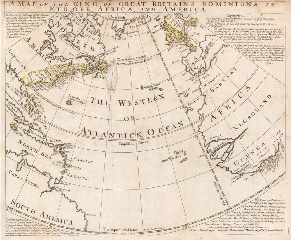
A Map of the King of Great Britain's Dominions in Europe, Africa, and America.
1740 (undated) 14.75 x 18 in (37.465 x 45.72 cm)
1740 (undated) 14.75 x 18 in (37.465 x 45.72 cm)
Description
This is a c. 1740 pre-French and Indian War Emmanuel Bowen map of the British Empire in Europe, Africa, and the Americas, or what historians refer to as the Atlantic World. Beautifully engraved and highly informative, the map centers on the Atlantic Ocean, with the Americas on the left and Europe and Africa on the right. Yellow outlining is used to identify which parts of the world 'are now possessed by the King of Great Britain', including the American colonies that became the United States, numerous islands in the Caribbean, and a pair of duchies in modern-day Germany. Areas outlined in green were formerly controlled by the British crown. Colonies, settlements, islands, or countries, are identified throughout, several which are underlined, identifying it as a possession of the Great Britain. These include Gibraltar, Charles Town (Charleston, South Carolina), and Acra (Accra, Ghana), etc. Information concerning the map and the Empire is situated in the corners, including an explanation of how to read the map and details related to British possessions in Asia.
Publication History
There is no definitive publication date. One source dates its publication at 1740, while another suggests 1752, and yet another puts forward a range from 1759-1763. One thing is certain, this map cannot postdate 1763 due to its depiction of Britain's American colonies. This depiction predates the 1763 Treaty of Paris which ended the French and Indian War. Under the terms of the treaty, France ceded the eastern portion of the Louisiana Territory (from the Mississippi River to the Appalachian Mountains) in this treaty, and here British possessions in North America end abruptly at the Appalachian Mountains.Cartographer
Emanuel Bowen (1694 - May 8, 1767) had the high distinction to be named Royal Mapmaker to both to King George II of England and Louis XV of France. Bowen was born in Talley, Carmarthen, Wales, to a distinguished but not noble family. He apprenticed to Charles Price, Merchant Taylor, from 1709. He was admitted to the Merchant Taylors Livery Company on October 3, 1716, but had been active in London from about 1714. A early as 1726 he was noted as one of the leading London engravers. Bowen is highly regarded for producing some of the largest, most detailed, most accurate and most attractive maps of his era. He is known to have worked with most British cartographic figures of the period including Herman Moll and John Owen. Among his multiple apprentices, the most notable were Thomas Kitchin, Thomas Jeffreys, and John Lodge. Another apprentice, John Oakman (1748 - 1793) who had an affair with and eventually married, Bowen's daughter. Other Bowen apprentices include Thomas Buss, John Pryer, Samuel Lyne, his son Thomas Bowen, and William Fowler. Despite achieving peer respect, renown, and royal patronage, Bowen, like many cartographers, died in poverty. Upon Emanuel Bowen's death, his cartographic work was taken over by his son, Thomas Bowen (1733 - 1790) who also died in poverty. More by this mapmaker...
Condition
Very good. Even overall toning. Light soiling. Some transference. Close top margin. Blank on verso.