This item has been sold, but you can get on the Waitlist to be notified if another example becomes available, or purchase a digital scan.
1762 Gentleman's Magzine Map of British North America
BritishEmpire-gentsmag-1762$375.00

Title
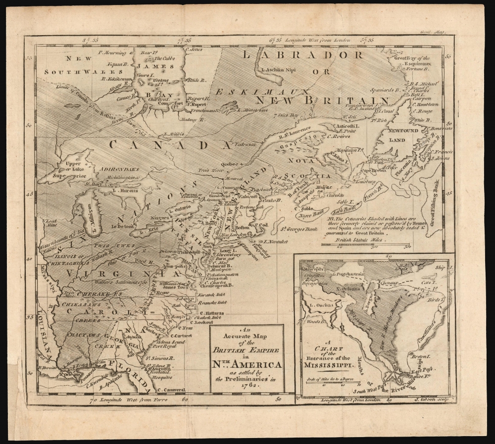
An Accurate Map of the British Empire in Nth. America as settled by the Preliminaries in 1762.
1762 (dated) 8.25 x 9.75 in (20.955 x 24.765 cm) 1 : 16000000
1762 (dated) 8.25 x 9.75 in (20.955 x 24.765 cm) 1 : 16000000
Description
This scarce, fascinating map of North America east of the Mississippi appeared in the 1762 end-of-year supplement of the Gentleman's Magazine. It revealed, to that magazine's readership, the vast prize of American land that Great Britain stood to gain at the expense of the French in the treaty negotiations then bringing the French and Indian War (1754 - 1763) to a close.
A Closer Look
It presents the region occupied by the British Colonies in North America, extending west to the Mississippi River but also northwards to include Labrador and James Bay. The shaded area highlights the massive territories which Britain would be awarded by the peace treaty then under discussion with France. An inset map to the lower right details the Mississippi delta region, then to be divided between the British (the shaded area to the east) and the Spanish (New Orleans and points west.)Debating the Gains: An Acceptable Peace?
Although the treaty was not ratified until 1763, the preliminary statements of the treaty were known, and were the subject of much discussion, not least in the pages of the Magazine. The conversation revolved around the question of whether the treaty should be accepted by the British people, or whether the war should be prosecuted further. The Magazine's editorial position, supported by the present map, was that the treaty represented a tremendous British gain which further war was unlikely to increase, and which could potentially be lost in the vicissitudes of further war:The Editors of the Gentleman's Magazine, think they cannot better close the year, than by adding a Map of North America, in which the territory now ceded and guaranteed to us, is ascertained, by a visible, indubitable, and unchangeable bound, the bank of a river, and so distinguished by transverse lines as to appear at one view. If the reader will take the trouble to refer to page 296 of our 25th volume, and compare the map there given with that which we have now exhibited, he will easily discern how much more we have gained by the present treaty than we claimed as our right at the commencement of the war, and were then in possession of.The map to which the editors alluded, John Lodge's 1755 A map of the British and French Settlements in North America, displayed a French advantage in territory over the British, particularly in the Great Lakes and Saint Lawrence River region. The present map, depicting specifically the lands 'formerly claimed or possessed by France and Spain… now absolutely ceded and guaranteed to Great Britain', dramatically presented a swath of land far larger than that which the 1755 map showed the French to even be claiming. It would be very difficult, having scrutinized the present map, for a Briton to claim that the treaty in progress amounted to anything less than a great British victory.
Publication History and Census
The map was engraved by John Gibson for inclusion in the end-of-year supplement to Volume 32 (1762) of the Gentleman's Magazine. We see only tree examples of the separate map listed in OCLC, in the Birmingham Public Library, in the Library of Congress, and in the Clements. In spite of its scarcity in institutional collections, it does appear at auction and in dealers' catalogs from time to time.CartographerS
The Gentleman's Magazine (fl. c. 1731 - 1922) was an English periodical founded by visionary Edward Cave. Considered the world's first monthly general interest magazine, GM was also known as Trader's Monthly Intelligencer. Cave's innovation was to create a monthly digest of news and commentary on any topic the educated public might be interested in, from commodity prices to Latin poetry. It carried original content from a stable of regular contributors, as well as extensive quotes and extracts from other periodicals and books. Cave, who edited The Gentleman's Magazine under the pen name "Sylvanus Urban", was the first to use the term "magazine" (meaning "storehouse") for a periodical. The iconic illustration of St John's Gate on the front of each issue (occasionally updated over the years) depicted Cave's home, in effect, the magazine's "office". Among the important firsts of the The Gentleman's Magazine are the first use of the term "magazine" for a periodical and the first regular employment of lexicographer Samuel Johnson. More by this mapmaker...
John Gibson (1724 – 1773) was an English map engraver active in London at the end of the 18th century. Gibson was the son of a locksmith. In 1739 he apprenticed to John Blundell as a stationer of Grub Street. Gibson proved a fine engraver and was much in demand by London map publishers. During his career he produced thousands of maps and was admired as a skilled engraver and sculptor. Among others, he engraved for Emanuel Bowen, Robert Sayer, Jean Palairet, John Rocque, Andrew Dury, and Benjamin Martin. His best known work was prepared in conjunction with Gentleman's Magazine. Gibson, sadly, was not as astute in his fiscal affairs as with the engravers pen and consequently spent much of his life consigned to debtor's prison. Learn More...
Source
Gentleman's Magazine, (London: D. Henry and R. Cave) December 1762.
Condition
Very good. Margin reinstated at insertion point; few mends with no loss.
References
OCLC 1250658676. Sellers, J. and van Ee, P. Maps and Charts of North America and the West Indies 1750-1789. #92. McCorkle, B. New England in Early Printed Maps 1513 to 1800 762.1. Jolly, David C. Maps of America in periodicals before 1800 #190.