This item has been sold, but you can get on the Waitlist to be notified if another example becomes available, or purchase a digital scan.
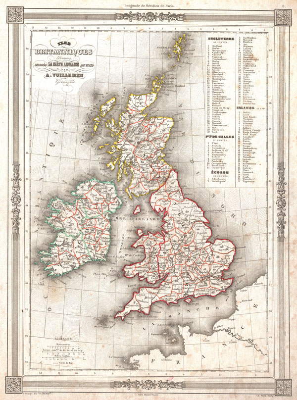
1852 Vuillemin Map of the British Isles (England, Ireland, Scotland)
BritishIsles-vuillemin-1852$68.50

Title
Iles Britanniques Dresees d'appres La Carte Anglaise de Wild.
1852 (undated) 12.5 x 9.5 in (31.75 x 24.13 cm)
1852 (undated) 12.5 x 9.5 in (31.75 x 24.13 cm)
Description
An uncommon and attractive 1852 map of the British Isles by A. Vuillemin. Details England, Scotland and Ireland as well as parts of neighboring France. Based on an earlier map by the English mapmaker Wild. Upper right corner features a list of counties which are numerically coded into the map. Features a beautiful frame style border. Prepared by A. Vuillemin for publication as plate no. 9 in Maison Basset's 1852 edition of the Atlas Illustre.
CartographerS
Alexandre Aimé Vuillemin (1812 - 1880) was an engraver, publisher, and editor based in Paris, France in the middle of the 19th century. Despite a prolific publishing career, much of Vuillemin's life is shrouded in mystery. In 1852, he married Josephine Caroline Goret and they had at least one child, Ernestine Adèle Vuillemin, later in the same year. What is known is that his studied under the prominent French Auguste Henri Dufour (1798 - 1865). Vuillemin's most important work his detailed, highly decorative large format Atlas Illustre de Geographie Commerciale et Industrielle. More by this mapmaker...
Maison Basset (1819 - 1865) was a French publishing concern active through the mid to late 19th century. The firm can trace their roots to André Basset (Bassett; fl. 1768 - 1784), who starting publishing maps, prints, and books around 1768. Maison Basset, also Chez Basset, is the imprint under which the heirs of Paul-André Bassett (1759 - 1829) operated after his death. From their offices at 64 Rue St. Jacques, then 33 Rue de Seine, Paris, France, Maison Basset published the works of such prominent French cartographers and engravers as Barbie du Bocage, A. Vuillemin, J. B. Charle, V. Levasseur, Tu. Duvotenay, H. Dufor, F. E. George, and others. Their library of publications is diverse and vast, but heavily focused on medical and scientific texts, including several important atlases. The firm is closely aligned with the Chéreau family of printers and engravers, with whom they were connected with multiple, often incestuous, marriages and remarriages. Learn More...
Source
Maison Basset, Atlas Illustre, (1852 issue).
Condition
Good condition. Exhibits some foxing mostly confined to margins. Else attractive and unusual.