1871 Bishop Pocket Map of Brooklyn, New York
Brooklyn-bishop-1871-2$1,250.00

Title
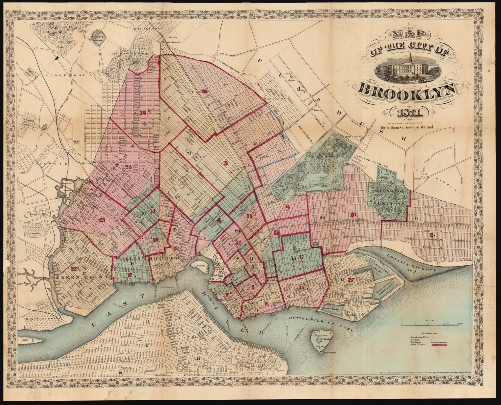
Map of the City of Brooklyn. 1871.
1871 (dated) 18.5 x 23.5 in (46.99 x 59.69 cm) 1 : 22500
1871 (dated) 18.5 x 23.5 in (46.99 x 59.69 cm) 1 : 22500
Description
This is a handsome example of William Bishop's 1871 pocket map of Brooklyn, New York. It captures Brooklyn as the third-largest city in the United States after a population boom in the wake of consolidation and the commercialization of the steam ferry.
A Closer Look
Surrounded with a decorative vine-and-leaf border, this attractive east-oriented map presents Brooklyn during the boom that characterized the second part of the 19th century. The street layout, mimicking the grid system of Manhattan, is shown in detail. The map notes important buildings, ferry crossings, bridges, train lines, and 'plank roads'. Also marked are public buildings and lands such as the Lunatic Asylum, the Hospital, the Alms House, the Military Parade Grounds, the Marine Hospital, and the Navy Yard. Manhattan appears in the lower left. Greenwood cemetery is depicted, as is Prospect Park, then under construction. (This is one of the first maps to show Olmstead's design.) An attractive cartouche includes a portrait of Brooklyn's City Hall. Cartographically this map references and expands upon the 1846 map of Brooklyn surveyed and prepared by Richard Butt.Exodus from Manhattan
In the mid-19th century, fueled by the advent of the steam ferry, which made crossing the East River practical, Kings County experienced an explosive population boom. Rich and poor alike abandoned the dirty and claustrophobic Manhattan for the suburban lands across the East River. In 1855, the communities of Brooklyn, Greenpoint, Bushwick, and Williamsburg consolidated into one large city, modern-day Brooklyn. It was around this time that the term 'Kings County' began to fall out of popular usage in favor of 'Brooklyn.' By 1865, Brooklyn had become the third largest city in America, behind New York and Philadelphia.Publication History and Census
This map was drawn by A. Brown of 47 Nassau Street, New York, for inclusion in William G. Bishop's 1871 Manual of the City and Corporation of Brooklyn. We see only four examples of this map in OCLC, appearing in Brooklyn, New York, and Queens Public Libraries, as well as the New York Historical Society.Cartographer
William Bishop (fl. c. 1855 - 1877) was the on-and-off city clerk of Brooklyn from about 1860 to the early 1870s. Bishop's primary opponent for the position was newspaperman Henry McCloskey. One of the duties of the city clerk was to publish an annual report detailing the government, progress, urban planning and development of the city. The resulting Manual of the Common Council of the City of Brooklyn was published each year of Bishop's tenure as city clerk. The first Brooklyn Manual was published in 1855 following the consolidation of the city. The Manual was published under various names and in various forms until 1888. More by this mapmaker...
Source
Bishop, William, Manual of the Common Council of the City of Brooklyn, 1871, (Brooklyn) 1871.
Condition
Fair. Mends at junctures of folds; two surface tears with minimal loss; margin chip reinstated with slight loss of border. Else very good.
References
OCLC 58758634. New York Public Library Map Div. 01-1836. Brooklyn Collection, Brooklyn Public Library, Document 51. Bulletin of the New York Public Library, Vol 4, 1902, Page 86.