1868 Dripps Map of Brooklyn, New York
Brooklyn-dripps-1868$900.00

Title
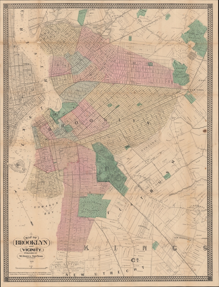
Map of Brooklyn and Vicinity.
1868 (dated) 26.75 x 20.25 in (67.945 x 51.435 cm) 1 : 22200
1868 (dated) 26.75 x 20.25 in (67.945 x 51.435 cm) 1 : 22200
Description
A rare 1868 map of Brooklyn, New York, by Matthew Dripps. This is also one of the first general maps of Brooklyn to include Prospect Park, which at the time was still under construction. When this map was issued Brooklyn was a bustling city but remained very much in the shadow of Manhattan. Today, Brooklyn is officially the 'Hippest place on earth!'
A Closer Look
Unlike most earlier maps of Brooklyn, which were oriented to the west, Dripps oriented his map to the northeast - and in doing so established a new convention followed by most subsequent Brooklyn maps. The map covers Brooklyn from Evergreen Cemetery and the Newtown Creek south to roughly 60th street and extends east to Clarkson Avenue and Fort Hamilton Avenue. It includes modern-day Brooklyn Heights, Williamsburg, Greenpoint, Fort Green, Bedford Stuyvesant, Bushwick, Park Slope, Flatbush, Clinton Hill, Boerum Hill, Prospect Heights, and Fort Green.Publication History and Census
This map published by Matthew Dripps in 1868. There is a roughly contemporaneous map of the same title, also by Dripps, at 200% scale. The map is held by approximately 5 institutional collections - often in poor condition.Cartographer
Matthew Dripps (1812 – April 9, 1896) was an Irish-born American mapmaker active in Philadelphia and New York during the second half of the 19th century. Dripps was born in Gracefield, Ireland. In Ireland, probably Belfast, he worked as a grocer. Dripps immigrated to American from Belfast on the Patrick Henry in 1849, arriving in Philadelphia, where he connected with the Reformed Presbyterian Church and worked briefly as a tax collector. His earliest recorded maps, depicting Philadelphia, appeared during this period. Dripps relocated to Brooklyn, New York in 1850, setting up shop as a map publisher. His two largest maps were published in the following years, 1850 and 1851, and combine to form an enormous map of Manhattan. These gained him the attention of the City Council, who used his maps for census and government work. Afterwards, he issued other large format New York City and Brooklyn maps as well as smaller maps for the New York City Clerk's office. He was married to Ameila Millar Dripps with whom he had six children, among them Amelia Dripps and the clergyman Joseph Frederick. Dripps is interred at Greewood Cemetery, Brooklyn. More by this mapmaker...
Condition
Good. Wear on old fold lines. Laid on archival tissue. Minor infill at some fold intersections.
References
OCLC 196498535.