This item has been sold, but you can get on the Waitlist to be notified if another example becomes available, or purchase a digital scan.
1911 Rand McNally Pocket Map of Brooklyn, New York
Brooklyn-randmcnally-1911$125.00

Title
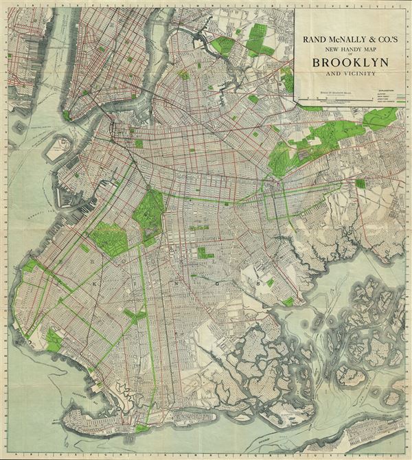
Rand McNally and Co.'s New Handy Map of Brooklyn and Vicinity.
1911 (dated) 31 x 27.5 in (78.74 x 69.85 cm) 1 : 26000
1911 (dated) 31 x 27.5 in (78.74 x 69.85 cm) 1 : 26000
Description
This is an excellent 1911 Rand McNally and Company map of Brooklyn, New York. It covers Brooklyn from Long Island City to the Rockaway Peninsula, including parts of Manhattan, Queens and Jersey City. This extremely detailed map identifies major and minor streets, individual buildings, parks, ferry lines, piers, cemeteries, street car lines, and several other topographical features. Prospect Park, Greenwood Cemetery, Governor's Island, City Hall, Navy yard, etc. are noted. The numerous marshy islands of Jamaica Bay are also included. This map was issued by Rand McNally and Company as the New Indexed Handy Map of Brooklyn and Vicinity in 1911.
Cartographer
Rand, McNally and Co. (fl. 1856 - present) is an American publisher of maps, atlases and globes. The company was founded in 1856 when William H. Rand, a native of Quincy, Massachusetts, opened a print shop in Chicago. Rand hired the recent Irish immigrant Andrew McNally to assist in the shop giving him a wage of 9 USD per week. The duo landed several important contracts, including the Tribune's (later renamed the Chicago Tribune) printing operation. In 1872, Rand McNally produced its first map, a railroad guide, using a new cost effective printing technique known as wax process engraving. As Chicago developed as a railway hub, the Rand firm, now incorporated as Rand McNally, began producing a wide array of railroad maps and guides. Over time, the firm expanded into atlases, globes, educational material, and general literature. By embracing the wax engraving process, Rand McNally was able to dominate the map and atlas market, pushing more traditional American lithographic publishers like Colton, Johnson, and Mitchell out of business. Eventually Rand McNally opened an annex office in New York City headed by Caleb S. Hammond, whose name is today synonymous with maps and atlases, and who later started his own map company, C. S. Hammond & Co. Both firms remain in business. More by this mapmaker...
Condition
Very good. Some wear and toning along original fold lines. Professionally flattened and backed with archival tissue. Accompanied by original paper binder.