
1939 Borough of Brooklyn City Map or Plan of Brooklyn w/ Manuscript Railroads

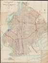
Office of the President of the Borough of Brooklyn Bureau of Highways and Sewers Division of Street Plan Records Map of the Borough of Brooklyn City of New York 1939.
Highlights railroad routes throughout Brooklyn just before World War II.
$750.00
Choose a Collection:
- Digital Map Information
- Suitable for large format printing
- File Size: 50.73 MB
- File Type: ZIP / TIFF
- ICC color profile embedded
- Delivered instantly via download link
This Item
Enquire
Highlights railroad routes throughout Brooklyn just before World War II.
This is a 1939 Bureau of Highways and Sewers city map or plan of Brooklyn, New York featuring manuscript notations highlighting railroad lines in the borough. The map depicts the region from The Narrows and Staten Island (labeled as Borough of Richmond) to Jamaica Bay and from Long Island City to the Atlantic Ocean. Myriad streets throughout Brooklyn are illustrated and labeled, along with the borough's many parks. Both Prospect Park and Greenwood Cemetery are illustrated in detail. Floyd Bennet Field, an airfield near Jamaica Bay, is also labeled. Some detail is present along the East River in Manhattan, including the Brooklyn Bridge, Manhattan Bridge, and Williamsburg Bridge spanning the river between Manhattan and Brooklyn.Manuscript Railroad Lines
Several rail lines throughout Brooklyn are highlighted here in manuscript with different colors used to differentiate between the lines and a key is situated in the lower left corner. The orange lines indicate routes and yards owned by the Long Island Railroad (L.I.R.R.), including the Montauk Branch (from Long Island City and Bushwick and originally known as the South Side Railroad of Long Island) and the Bay Ridge Branch (originally opened as the New York, Bay Ridge and Jamaica Railroad in 1876). Today, only freight trains operate along the Bay Ridge Branch. The South Brooklyn Railway, which was founded in 1887, is marked here in purple. This railway operated under several different names and owners until it was acquired by the Brooklyn-Manhattan Transit Corporation in in the mid-1920s. Operation was transferred to the city on June 1, 1940, but use continued to decline throughout the second half of the 20th century. Today, the South Brooklyn Railway runs freight operations from the 36th-38th Street Yard, but most of the traffic is subway connections to the L.I.R.R. Bay Ridge Branch. Two specific rail networks, those used at the Bush Terminal and at the New York Docks are marked as well.Publication History and Census
This map is most likely one of a kind. The base map was created and published by the Division of Street Plan Records of the Bureau of Highways and Sewers of the Office of the President of the Borough of Brooklyn in 1939, and we have been unable to locate any other known examples. That said, this example was repurposed by the Pennsylvania Railroad to illustrate railroad routes and ferries, making it a unique find.Condition
Very good. Dissected and mounted on linen in 35 panels.