This item has been sold, but you can get on the Waitlist to be notified if another example becomes available, or purchase a digital scan.
1945 U.S. Hydrographic Nautical Map of Buckner Bay, Okinawa
BucknerBay-hydrographicoffice-1945$150.00

Title
Nansei Shoto. Okinawa Shima. Buckner Bay. (Nakagusuku Wan).
1945 (dated) 16.5 x 21.5 in (41.91 x 54.61 cm) 1 : 50000
1945 (dated) 16.5 x 21.5 in (41.91 x 54.61 cm) 1 : 50000
Description
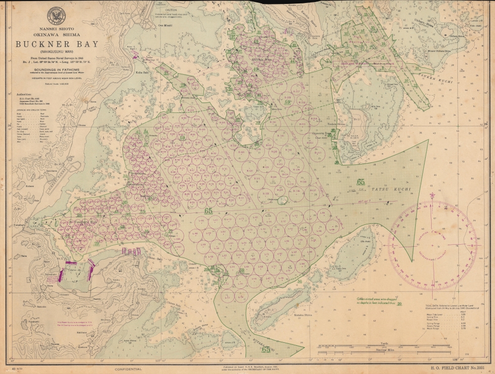
This is a 1945 U.S. Navy Hydrographic Office nautical chart or map of Buckner Bay or Nakagusuku Wan, Okinawa illustrating preparations for Operation Downfall, the planned invasion of Japan's Home Islands. Significantly, this is one of the few surviving charts published on board the U.S.S. Bowditch.
A Closer Look
Focusing on Nakagusuku Bay, or Buckner Bay as it was known by American servicemen (in memory of Lieutenant General Simon Bolivar Buckner, Jr. who was killed in action during the Battle of Okinawa), purple circles illustrate berths for ships. Each circle is labeled alphanumerically (L-163, for example). The size of circle represents the class of ship for which the berths are intended. The green shaded areas have been wire-dragged to given depths. Two seaplane runways are illustrated in purple in the upper right along with a plane mooring area. Roads, runways, and small towns are illustrated along Okinawa's coast.The U.S.S. Bowditch
The U.S.S. Bowditch began as the Santa Inez, a Danish passenger ship launched in 1929 by Burmeister and Wain. The U.S. Navy purchased the Santa Inez on March 4, 1940, after which she received a temporary commission. She was sent to the Norfolk Navy Yard, outfitted as a survey ship, and renamed the U.S.S. Bowditch. Bowditch undertook several geodetic survey missions in the Caribbean before leaving Norfolk in January 1942 for South America and the Pacific. After returning in Norfolk for repairs in November 1942, she returned to the Pacific in February 1943, where she remained until she was assigned to the Service Force, Pacific Fleet. Bowditch arrived in Pearl Harbor on January 6, 1944, and participated as a survey ship during the invasion of Kwajalein and Majuro Atolls (February 4 - April 2, 1944), the occupation of Saipan (July 22 - October 4, 1944) and the capture of Okinawa (April 18 - September 2, 1945). Bowditch helped rescue survivors of the U.S.S. Montgomery and the U.S.S. Force during her time off Okinawa. She left Okinawa on November 3, 1945, and returned to the United States. Bowditch took part in the preliminary surveys of Bikini Atoll for Operation Crossroads, leaving San Francisco on February 17, 1946. She remained in Bikini after the atomic bomb tests and finally returned to San Francisco on October 19, 1946. She was decommissioned at Norfolk on January 31, 1947, and transferred to the Maritime Commission on June 9, 1948.Publication History and Census
This map was compiled from U.S. Navy Hydrographic Chart No. 6132, Japanese Chart No. 282, and surveys conducted by the U.S.S. Bowditch in 1945 and published on board the U.S.S. Bowditch in August 1945 with corrections up to August 22 as Hydrographic Office Field Chart No. 2031. This is the only known surviving example of this edition of this chart and one of four known surviving cataloged charts that were printed on board the U.S.S.Bowditch during World War II. An example of this chart dated July 1945 is part of the collection at the National Library of New Zealand.Cartographer
United States Hydrographic Office (1866 - 1962) was a brach of he U.S. Navy that prepared and published maps, charts, and nautical books to aid in navigation. Before the establishment of the Hydrographic Office in 1866, U.S. navigators were almost entirely dependent on British charts. There had been a few private enterprises that had prepared and published charts, but none had been able to do so profitably. The Office was established 'for the improvement of the means of navigating safely the vessels of the Navy and of the mercantile marine, by providing, under the authority of the Secretary of the Navy, accurate and cheap nautical charts, sailing directions, navigators, and manuals of instructions for the use of all vessels of the United States, and for the benefit and use of navigators generally.' This way the Navy Department could furnish navy and merchant ships with charts illustrating the results of surveys and explorations undertaken by naval officers. The charts were priced to cover the cost of paper and printing alone, not preparation. Its main objective was to survey foreign coasts, as the Coast and Geodetic Surveys were responsible for surveying domestic waters. The Hydrographic Office was transferred from the Department of the Navy to the Department of Defense in 1949 and was replaced by the Naval Oceanographic Office in 1962. More by this mapmaker...
Condition
Average. Staple holes along top and bottom edges. Top truncated into printed image with loss of top border and some content. Priced accordingly.