This item has been sold, but you can get on the Waitlist to be notified if another example becomes available, or purchase a digital scan.
1838 Schmid Map of Budapest, Hungary (Great Flood)
Budapest-schmid-1838$1,000.00

Title
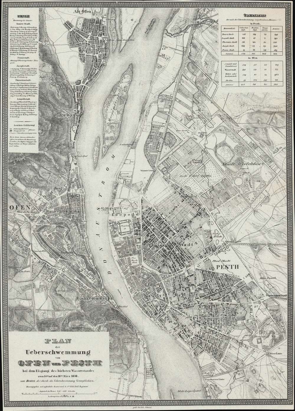
Plan der Ueberschwemmung von Ofen und Pesth bei dem Eisgang des höchsten Wasserstandes vom 15ten auf den 16ten März 1838.
1838 (dated) 23.25 x 16.75 in (59.055 x 42.545 cm) 1 : 30000
1838 (dated) 23.25 x 16.75 in (59.055 x 42.545 cm) 1 : 30000
Description
An extremely rare 1838/1839 infographic map of Budapest, Hungary, issued directly following the disastrous Great Danube Flood of 1838 - likely the greatest natural disaster in Budapest history. Coverage embraces Pest, Buda, and Óbuda. The map shows the high-water marks on both the Buda and Pest sides of the Danube - although the Buda side, being of higher elevation, was mostly unharmed, while the Pest side, a flood plain, was completely destroyed. It also illustrates areas of higher elevation within Pest where residents took refuge. The detail throughout is strikingly granular, with hachured buildings representing surviving structures, and black buildings those that fully collapsed.
The Devastation
The table in the upper right takes into account damages to buildings in both Pest and Buda by city district and in total (in Pest it gives the data of Downtown, Lipótváros, Terézváros, Józsefváros and Ferencváros, Budán Újlak and Országút, Víziváros, Tabán or Rácváros and Óbuda). According to the table, 2281 of the 4254 houses in Pest collapsed, 827 were damaged, 601 of the 3251 houses in Buda collapsed and 536 needed to be repaired. Interestingly, the 22 houses destroyed in the Óbuda Jewish quarter were not included in the original statistics.The Great Danube of 1838
The icy flood of March 1838 was one of the greatest disasters in Hungarian history, inundating most of the Pest part of Budapest under 2.6 meters of water. The flood resulted from the erratic melting and freezing patters of the Danube between Vienna and Budapest in late winter. As this map shows, Óbuda, much of Teréz, József and Ferencváros were almost completely submerged, as no intact houses remained in vast sections. The flood is described by GIS analysts, András Tenk and Dávid Lóránt,The story of the 1838 flood can be reconstructed as follows. The Kopaszi Bar used to lie in the section between today’s two bridges: the Szabadság Bridge and the Southern Railway Bridge [Déli összekötő vasúti híd]. Here the river widened to almost 1 km, and the reef ran from the right bank to the centre of the riverbed. Just south of the Kopaszi Bar, the Danube branched at the northern tip of the more than 50 km long island, the Csepel Island. The left Danube branch, the Soroksári Branch, has always been narrower and shallower than the main river branch. Therefore, the drifting ice could block the narrow watercourse. Further ice floes coming from the north piled up on the already present ice barrier in the Soroksári Branch at the tip of the large island, creating a 4-5 m high ice wall.
… The weather stayed very cold during February, with temperatures below -18 ºC. When finally milder days came at the end of February and at the beginning of March, the water level suddenly rose to 670 cm by 9th March (Lászlóffy, 1938). … In Pest, about 1,300 acres (748 ha) of the populated area was flooded, with only about37 acres (21 ha) remaining dry. (Tank, A., and Lóránt, D., 'Geographical and GIS Analysis of the Great Flood of 1838 in Pest-Buda', Geographia Technica, Vol. 10, Issue 1, 2015, page 77-89.)
The Solution
After the flood, Hungarians realized this kind of disaster could easily happen again and so contracted engineers to create a massive drainage canal and a network of poldars to contain potential future floods. The track of the canal is shown here from roughly, today's Boráros Tér. to roughly Hösök Tere. Despite the enormity of the work, it was completed by June 1838.Publication History and Census
This map was printed in 1838 or 1839, shortly following the Great Danube Flood of 1838. The map was engraved in Budapest by János Schmid. Some have suggested that the cartography is the work of Sámuel Blaschek, an important Hungarian cartographer of the period, but this is unverified. Outside of 3 institutional collections in Hungary, the map is extremely rare, with no market history.Cartographer
János Schmid (fl. c. 1807 - 1839) was a lithographer and engraver based in Budapest in the first half of the 19th century. He produced maps, sheets music, and other job ephemera. Schmid was born in Basel, Switzerland. He was active as a printer form at least 1807. Around 1820, he established press in Buda (Budapest). The press was relocated to the Pest side of the river in 1828. An unfortunate choice being that Pest was flooded and mostly destroyed in 1838. Nonetheless, Schmid survived and in 1839 issued the definitive post-flood plan of Budapest. More by this mapmaker...
Condition
Good. Minor border infill repairs upper right.
References
OCLC 1087845946. Univerzita Karlova, 001288039.