1888 Curtis Real Estate Map of Buena Vista, Hancock County, Maine
BuenaVista-curtis-1888$500.00

Title
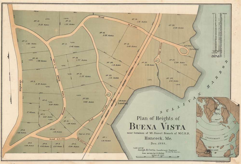
Plan of Heights of Buena Vista near terminus of Mt. Desert Branch of M.C.R.R. Hancock, Me. Dec. 1888.
1888 (dated) 18.75 x 27.75 in (47.625 x 70.485 cm) 1 : 1200
1888 (dated) 18.75 x 27.75 in (47.625 x 70.485 cm) 1 : 1200
Description
A curious 1888 real estate map promoting the planned summer community of Buena Vista on Hancock Point, on Frenchman's Bay, near Sullivan Harbor and Mount Desert Island. Although apparently never constructed, the development looks impressive, with expansive lots ranging from one to 5 acres, winding roadways, and easy access to the highway, railroad, and boat landings in Sullivan Harbor. The entire development covered some 60 acres, including roads.
Historical Context
In the 1880s, Mount Desert Island, particularly Bar Harbor, had a Newport-like reputation as a haven for the monied elite of New England. Various real estate speculation schemes popped in the immediate vicinity hoping to piggyback on Mount Desert's 'rusticator' popularity. Buena Vista was one such development, in this case following the 1884 completion of the Maine Central Railroad connecting Hancock with Portland and Boston. The assumption that surrounding communities would rise in the wake of the railroad was sound - from 1884 to 1886 tourism to Bar Harbor alone quadrupled.Publication History and Census
This map was printed by the Heliotype Printing Company of Boston based upon surveys by J. G Kelly. Buena Vista itself was laid out by Joseph H. Curtis of Boston. Rare. We note examples at Yale, the University of Maine, Boston Athenaeum, and (in another state) the Osher Map Library.Cartographer
The Heliotype Printing Company (1872 - c. 1900) was a printing company based in Boston. The company was promoted as 'artistic printers by the best photogelatine and photolithographic processes.' They were reorganized in 1885, adapting chromolithographic and photo reprographic techniques. They remained active until at least the 1930s. Their offices were located at 211 Tremont Street, Boston. More by this mapmaker...
Condition
Very good. Minor dampstaining to corners. Minor reinstatement lower left corner.
References
OCLC 181101161.