This item has been sold, but you can get on the Waitlist to be notified if another example becomes available, or purchase a digital scan.
1913 De Roos City Map or Plan of Buenos Aires, Argentina
BuenosAires-deroos-1913$112.50

Title
Plan of the Town of Buenos Aires.
1913 (dated) 18.75 x 27.5 in (47.625 x 69.85 cm) 1 : 38000
1913 (dated) 18.75 x 27.5 in (47.625 x 69.85 cm) 1 : 38000
Description
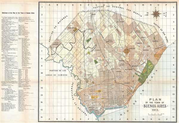
This is a 1913 Johan de Roos city map or plan of Buenos Aires, Argentina. Situated toward the west, the map depicts the city from the Partido de Matanza, the Partido de las Lomas de Zamora, and the Partido de Avellaneda to the Rio de la Plata and from the Partido de General San Martin to the Rio de la Plata and the Partido de Avellaneda. Numerous districts within the city are labeled, including Villa Santa Rita, Villa Devoto, Villa de la Catalinas, La Boca, Palermo, and Almagro. Streets are labeled in the historic city center, along with the Plaza de Armas, the cemetery, and the Plaza Constitucion. The Parque 3 Febrero is illustrated in detail along the Rio de la Plata, including the Hipodromo Argentino. A grid is superimposed on the city that corresponds with an index located along the left side. Government buildings, churches, temples, banks, theaters, bazaars, and railway stations are among the locations listed.
This map was produced by Johan de Roos and published in 1913.
This map was produced by Johan de Roos and published in 1913.
Condition
Very good. Even overall toning. Light wear along original fold lines. Light soiling. Verso repairs to fold separations. Blank on verso.
References
OCLC 902604267.