1943 Survey Headquarters Diazotype Manuscript Map of the Burma Campaign
BurmaBackground-surveyhq-1943$1,800.00

Title
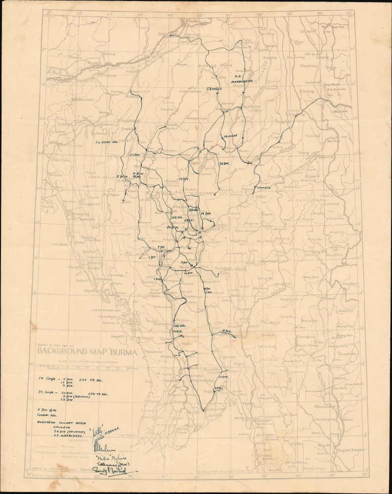
Background Map 'Burma'.
1943 (dated) 25.5 x 19.5 in (64.77 x 49.53 cm) 1 : 2534400
1943 (dated) 25.5 x 19.5 in (64.77 x 49.53 cm) 1 : 2534400
Description
This is a 1943 Survey Department diazo / whiteprint map of Burma (Myanmar) during World War II featuring one-of-a-kind manuscript annotations. These annotations follow the advance of the 1944 – 1945 Allied campaign to recapture Burma from the Japanese and present a more detailed look at this scarcely remembered campaign than any contemporaneous printed map.
A Closer Look
Depicting the from Shillong, India to the Mekong River, forming the border between Myanmar and Thailand, and from Sadiya to the Gulf of Martaban and the Indian Ocean, the map offers impressive detail throughout, covering transportation networks and hubs, specifically roads, railways, and river systems.Manuscript Map of the Burma Campaign, 1944 – 1945
Manuscript overwriting in black follows the course of the World War II (1939 - 1945) Burma Campaign in detail. Black lines illustrate the movements of various units. Some were part of the IV Corps or the 33rd Corps, which moved south toward Rangoon (Yangon) following the Japanese defeats at Imphal and Kohima in India. This mixed force of British, Commonwealth, and American units reached Rangoon after months of heavy fighting. In an effort to reopen the Burma Road, another army, consisting of Chinese regulars under American command, and the 5307th Composite Unit 'Merrill's Marauders', fought the Japanese south from Dibrugargh, India to Myitkyina and Bhamo. A key in the lower left details the units involved in the 1944 - 1945 Burma Campaign, noting the corps to which the various divisions were attached. Four undoubtedly important but undecipherable signatures appear in the lower left.The China Burma India Theater
The China Burma India Theater (CBI) was a second front for the Western Allies in the Pacific War. Burma, another British colony, was caught between British India and conquered/allied Japanese territory to the east. The Americans also viewed India as a base of operations to resupply Chiang Kai-shek's Chinese nationalists, an effort which bogged down hundreds of thousands of Japanese troops, making them unavailable to fight elsewhere. In the Spring of 1942, the Japanese launched an offensive aimed at conquering Burma and closing overland supply routes to China. This campaign proved successful, and the Japanese pushed the Allies out of Burma and back into India.The Burma Campaign of 1944 – 1945
The 1942 defeats and subsequent losses in 1943 forced the Allies to reevaluate. In August 1943, a commando unit led by Major General Frank Merrill, 'Merrill's Marauders,' infiltrated Burma where they utilized guerrilla tactics to harass the Japanese. In February 1944, the Marauders attacked the Japanese 18th Division, allowing other elements of the American army under General Stilwell to gain a foothold in Burma. Following the Japanese defeats at Imphal and Kohima later in 1944, which stalled the Japanese invasion of India, the Allies began moving south in pursuit. The Allies won victories at Meiktila and Mandalay before liberating Rangoon (Yangon) in May.Diazo Print or Whiteprint
The diazo print (whiteprint or diazo for short) is a photo reproductive technique best understood as a reverse cyanotype or blueprint. The process yields distinctive blue lines on white paper. Like cyanotypes, the diazo process gained popularity in architecture circles, where it was a simple and effective way to duplicate documents in the field. The earliest diazotypes appeared around 1880 and were adopted for military and field cartographic use from about 1895. The diazo process was commercialized in 1923, when the German firm Kalle and Company developed Ozalid, a patented diazo paper that made diazotyping even easier. By the 1950s, it supplemented cyanotypes as the reprographic technique of choice for technical drawings.Publication History and Census
This map was compiled by Survey Headquarters and printed in June 1943. The present diazo may date anywhere from the second half of 1943 to 1945, when the manuscript annotations were added. The manuscript notations date from late 1945, with one of the signatures dated as December 12, 1945. This is the only known example.Condition
Very good. Diazotype or whiteprint. Light wear along original fold lines. Manuscript notations in pen. Blank on verso.