1829 Crawfurd Map of Burma or Myanmar - first accurate map of Burma!
BurmanDominions-walker-1829$1,000.00

Title
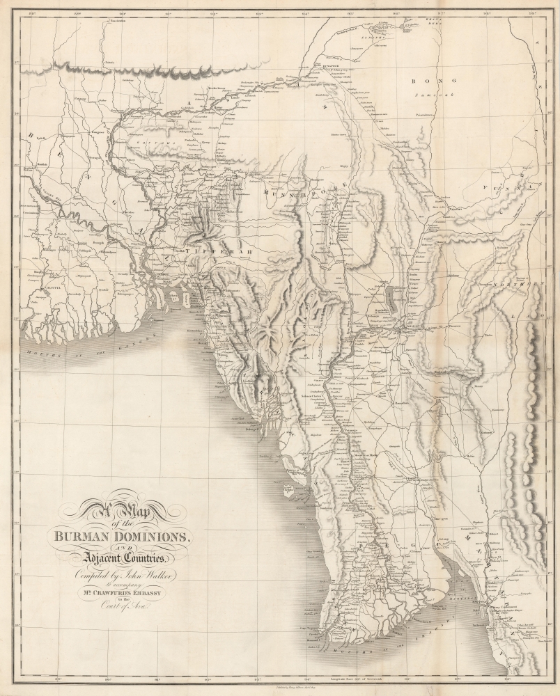
Map of the Burman Dominions, and Adjacent Countries.
1829 (dated) 30.5 x 24.5 in (77.47 x 62.23 cm) 1 : 1900000
1829 (dated) 30.5 x 24.5 in (77.47 x 62.23 cm) 1 : 1900000
Description
This is an 1829 John Crawfurd and John Walker map of Burma (Myanmar). The map, considered the first accurate map of this region, was prepared to illustrate John Crawfurd's Embassy to Ava to negotiate with Burmese King Bagyidaw following the First Anglo-Burmese War (1824 - 1826).
When Bagyidaw ordered his troops to peruse rebels into British territory, the war began. With an ill-defined border and rugged mountainous jungle territory, the First Anglo-Burmese War turned out to be one of the longest, most expensive, and bloodiest wars in the history of British India. Nonetheless, it ended decisively for the British, despite throwing British India into a severe economic crisis and ultimately contributing to the demise of the British East India Company's remaining privileges
For the Burmese Empire, it was the beginning of the end. The Third Burmese Empire, for a brief time the terror of British India, was crippled and no longer a threat to the eastern frontier. The Konbaung Dynasty itself went through a sharp decline until, ultimately, all of Burma was under British control.
A Closer Look
Centered on the Irrawaddy Valley, the map depicts from Calcutta to Yunnan Province in China and northern Laos and from Tassisudon to the mouths of the Irrawaddy River and the Gulf of Martaban. Dozens of villages, towns, and cities are labeled all along the Irrawaddy River from Rangoon to Mandalay, in the Irrawaddy Delta, and on the roads from Rungpoor to Bhamo and from Bhamo to Amarapura, but otherwise much is left blank, illustrating how little this region was known to European powers of the early 19th century.First Anglo-Burmese War
Bagyidaw, aka Sagaing Min, the seventh king of the Konbaung Dynasty of Burma (1784 - 1846), inherited an empire near its height in terms of both territory and military power. He was unfortunate enough to share a border with British India, which had an interest in expanding its holdings into Burma. The British fostered rebellions in Bagyidaw's border provinces, including Arakan, Manipur, and Assam, all of which had been brought into the fold of Burmese dominion by Bagyidaw's grandfather.When Bagyidaw ordered his troops to peruse rebels into British territory, the war began. With an ill-defined border and rugged mountainous jungle territory, the First Anglo-Burmese War turned out to be one of the longest, most expensive, and bloodiest wars in the history of British India. Nonetheless, it ended decisively for the British, despite throwing British India into a severe economic crisis and ultimately contributing to the demise of the British East India Company's remaining privileges
Crawfurd Mission to Ava, 1826
In the aftermath of war, Lord Amherst sent John Crawfurd on an envoy mission to Burma to negotiate terms with the chastised King Bagyidaw. Crawfurd and his party traveled up the Irrawaddy from Rangoon to Ava on the paddle steamer Diana with four support boats. Arriving at the Court of Ava, Crawfurd negotiated a complete surrender of Assam, Manipur, Cachar, Jaintia, Arakan Province, and Tenasserim to British India. The king also conceded to a trade agreement in return for a delay in indemnity payments and later sent his own mission to Calcutta.For the Burmese Empire, it was the beginning of the end. The Third Burmese Empire, for a brief time the terror of British India, was crippled and no longer a threat to the eastern frontier. The Konbaung Dynasty itself went through a sharp decline until, ultimately, all of Burma was under British control.
Scientific and Reconnaissance Tour de Force
The Crawfurd expedition was forced to delay its return to India so that the shallow-draft riverboats cold be repaired. They used the time to gather intelligence on the region, contributing to this map, as well as collect seven chests of fossils from the riverbank near Magwe, and nearly 18,000 botanical specimens for the Calcutta Botanical Garden. The work led to the discovery of a new species of mastodon, the Stegolophodon. It also provided the first accurate data regarding the interior of Burma, laying the groundwork for further British dominance in the region.Publication History
This map was published in 1829 to accompany Journal of an Embassy from the Governor General of India to the Court of Ava by John Crawfurd. It was engraved by John Walker and published in London. It does not appear in all editions of Crawfurd's narrative and there appears to be only one edition.CartographerS
John Walker (1787 - April 19, 1873) was a British map seller, engraver, lithographer, hydrographer, geographer, draughtsman, and publisher active in London during the 19th century. Walker published both nautical charts and geographical maps. His nautical work is particularly distinguished as he was an official hydrographer for the British East India Company, a position, incidentally, also held by his father of the same name. Walker's maps, mostly published after 1827, were primarily produced with his brothers Charles Walker and Alexander Walker under the imprint J. and C. Walker. Among their joint projects are more than 200 maps for the influential Society for the Diffusion of Useful Knowledge Atlas (SDUK). In addition they published numerous charts for James Horsburgh and the British Admiralty Hydrographic Office, including Belcher's important map of Hong Kong and Carless' exploratory map of Karachi. The J. and C. Walker firm continued to publish after both Walkers died in the 1870s. More by this mapmaker...
Henry Colburn (1784 - August 16, 1855) was a British publisher. Colburn started off in the publishing profession in the Albemarle Street shop of William Earle, a bookseller in London. His next move was to become an assistant at a circulating library on Conduit Street called Morgan's Library, which he took over in 1816. Eventually he signed this business over to Messrs. Saunders and Otley and opened his own publishing firm. He gained initial success with the roman à clef novel Glenavron by Lady Caroline Lamb and which was published in 1816. It went through four editions and sold well. Colburn later expanded on the success of Glenavron and published a series of so-called 'Silver Fork Novels', a series of books that afforded readers the thrill of peering into the lives of rich and aristocratic families. Colburn also started several periodicals, including the New Monthly Magazine, the Literary Gazette, the earliest weekly newspaper dedicated to literature, science, and the arts. Colburn married twice. His second marriage was to Eliza Anne, who survived him. Learn More...
Condition
Very good. Light wear and toning along original fold lines. Closed 6.5 inch tear alongthe right border professionally repaired on verso. Verso repairs to fold separations. Close right margin. Blank on verso.