This item has been sold, but you can get on the Waitlist to be notified if another example becomes available, or purchase a digital scan.
1879 Wyld Map of Southeast Asia: Burma, Thailand, Malaya, Singapore, Vietnam
BurmanEmpire-wyld-1879$500.00

Title
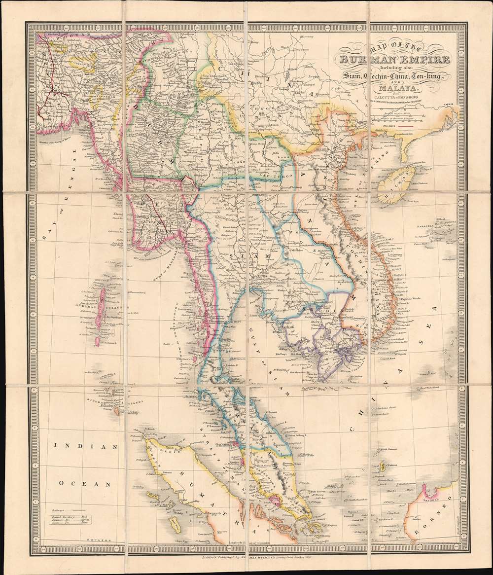
Map of the Burman Empire Including also Siam, Cochin-China, Ton-king and Malaya from Calcutta to Hong Kong.
1879 (dated) 18 x 16 in (45.72 x 40.64 cm) 1 : 7900000
1879 (dated) 18 x 16 in (45.72 x 40.64 cm) 1 : 7900000
Description
This 1879 James Wyld map of Southeast Asia highlights a vital section of the British Empire's 19th-century global trade network known as the 'Maritime Silk Road'. Depicting from Calcutta to Hong Kong and from Darjeeling to Singapore, Sumatra, and Borneo, this trade network operated for most of the 19th century, but, after the British moved the capital of British India to New Delhi in the early 20th century, Calcutta's importance gradually faded.
Singapore and Hong Kong
During the 19th century, Singapore and Hong Kong experienced similar evolutions. Both cities flourished under British dominion, growing from small, relatively sparsely populated islands, into bustling international trade hubs. Singapore acted as a link between the Far East and India and the recently opened Chinese market. Hong Kong provided a gateway to Chinese markets and supplied a natural transfer point for products moving in and out of China. Neither Singapore nor Hong Kong produced their own products. However, both created environments conducive to internationalism and the blending of cultures.Calcutta
Calcutta, named the capital of British India in 1772, evolved differently than Singapore and Hong Kong. One of the apparent differences that played a critical role is that Calcutta, unlike the other two cities, is not situated on an island. This allowed the city to develop into a large international market city, transforming the countryside around the city into areas devoted to trading. Also, as it was a vital port, Calcutta exported nearly half the tea, cotton, sugar, coal, and saltpeter produced in India by the late 18th century. Since Calcutta was the capital, it also benefitted from access to an extensive road and railway network, which allowed goods and workers to arrive in the city easily. Calcutta's large navigable river, the Hooghly, also played a crucial role in its growth.Publication History and Census
This map was created and published by James Wyld in 1879. One example is cataloged in OCLC and is part of the collection at the National Library of Australia. The OCLC also records four earlier editions, and we have also encountered at least two other earlier editions that are not present in OCLC.Cartographer
Wyld (1823 - 1893) was a British publishing firm active throughout the 19th century. It was operated by James Wyld I (1790 - 1836) and his son James Wyld II (November 20, 1812 - 1887) were the principles of an English mapmaking dynasty active in London during much of the 19th century. The elder Wyld was a map publisher under William Faden (1749 - 1836) and did considerable work on the Ordinance Survey. On Faden's retirement in 1823, Wyld took over Faden's workshop, acquiring many of his plates. Wyld's work can often be distinguished from his son's maps through his imprint, which he signed as 'Successor to Faden'. Following in his father's footsteps, the younger Wyld joined the Royal Geographical Society in 1830 at the tender age of 18. When his father died in 1836, James Wyld II was prepared to fully take over and expand his father's considerable cartographic enterprise. Like his father and Faden, Wyld II held the title of official Geographer to the Crown, in this case, Queen Victoria. In 1852, he moved operations from William Faden's old office at Charing Cross East (1837 - 1852) to a new, larger space at 475 Strand. Wyld II also chose to remove Faden's name from all of his updated map plates. Wyld II continued to update and republish both his father's work and the work of William Faden well into the late 1880s. One of Wyld's most eccentric and notable achievements is his 1851 construction of a globe 19 meters (60 feet) in diameter in the heart of Leicester Square, London. In the 1840s, Wyld also embarked upon a political career, being elected to parliament in 1847 and again in 1857. He died in 1887 following a prolific and distinguished career. After Wyld II's death, the family business was briefly taken over by James John Cooper Wyld (1844 - 1907), his son, who ran it from 1887 to 1893 before selling the business to Edward Stanford. All three Wylds are notable for producing, in addition to their atlas maps, short-run maps expounding upon important historical events - illustrating history as it was happening - among them are maps related to the California Gold Rush, the New South Wales Gold Rush, the Scramble for Africa, the Oregon Question, and more. More by this mapmaker...
Condition
Very good. Dissected and mounted on original linen. Original linen backing stable.
References
OCLC 277142537.