This item has been sold, but you can get on the Waitlist to be notified if another example becomes available, or purchase a digital scan.
1831 Norie Map of the Andaman Islands, South Burma, and Thailand West Coast
BurmaThailandAndamanNicobar-norie-1831$600.00

Title
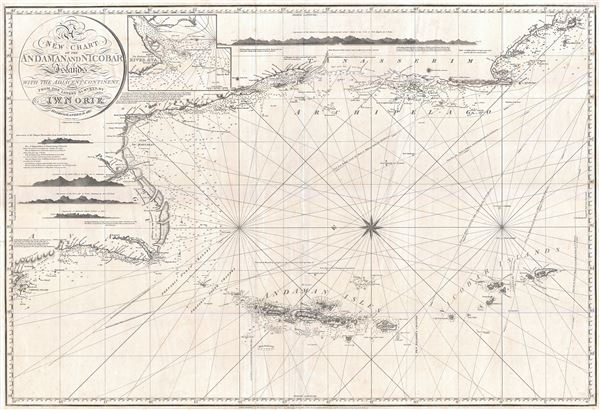
A New Chart of the Andaman and Nicobar Islands with the Adjacent Continent, Drawn from the latest Surveys, by J. W. Norie, Hydrographer.
1831 (dated) 25.5 x 37.5 in (64.77 x 95.25 cm) 1: 1627000
1831 (dated) 25.5 x 37.5 in (64.77 x 95.25 cm) 1: 1627000
Description
An extremely scarce 1831 nautical chart or maritime map by J. W. Noire depicting the Andaman Islands and Nicobar Islands as well as parts of modern-day Burma (Pegu) and Thailand (Tanasserim). Oriented to the East, Norie's map covers from Ramree Island and Sandoway (today a popular resort known as Nagapali Beach, Myanmar), then south east around Pegu and past Rangoon (Yangon), then along the Myanmar and Thai coastline as far south as Ko Tarutao (Trotto), in modern day south Thailand. The map includes the large Thai coastal city of and island of Phuket, then known as Junkseylon Island.
Andaman and Nicobar
The foci of this map, as the title suggests, are the Andaman and Nicobar Islands. The Andaman Islands were well known even in antiquity. Though Ptolemy may have mentioned them under a different name, they were definitely referred to by 9th century Arab geographers. In the 10 century the Persian navigator Buzurg ibn Shahriyar of Ramhormuz refers to them in his narrative Ajaib al-Hind (The wonders of India). Shahriyar describes the inhabitants of Great Andaman as fierce cannibals - a reputation they would maintain will into the late 19th century. Marco Polo also refers to the Andamans where, in one of his more whimsical and memorable passages, he describes the inhabitants as having heads like dogs.Mapping the Aandamans
Alhtough first mapped in some detail in the late 1780s by British naval commanders, the Andaman Islands remained in relatively obscurity well into the early 19th century. The British founded several minor colonies on the island including the penal colonies of Port Chatham and Port Cornwallis. These initial forays into settling the islands were general failures due to high instances of disease and an exceptionally fierce indigenous population. In 1824, shortly after Norie issued the 1817 first edition of this map, the Andaman Islands attained greater significance. Port Cornwallis, on the northwestern coast of Great Andaman, was chosen as a staging point for British fleets transporting troops to Pegu to fight in the First Burmese War. During this period the British reconnoitered the coastline, an effort that yielded a wealth of new information which no doubt found its way on to this 1831 updated version of the chart. Even so, the archipelago was hazardous to navigate and throughout the 1830s and 1840s was the site of countless shipwrecks. The survivors of these shipwrecks were rarely seen again - victims of vicious indigenous anthropophagi.Blueback Charts
Blueback nautical charts began appearing in London in the late 18th century. Bluebacks, as they came to be called, were privately published large format nautical charts known for their distinctive blue paper backing. The backing, a commonly available blue manila paper traditionally used by publishers to warp unbound pamphlets, was adopted as a practical way to reinforce the low-quality paper used by private chart publishers in an effort to cut costs. The earliest known blueback charts include a 1760 chart issued by Mount and Page, and a 1787 chart issued by Robert Sayer. The tradition took off in the early 19th century, when British publishers like John Hamilton Moore, Robert Blachford, James Imray, William Heather, John William Norie, Charles Wilson, David Steel, R. H. Laurie, and John Hobbs, among others, rose to dominate the chart trade. Bluebacks became so popular that the convention was embraced by chartmakers outside of England, including Americans Edmund March Blunt and George Eldridge, as well as Scandinavian, French, German, Russian, and Spanish chartmakers. Blueback charts remained popular until the late 19th century, when government subsidized organizations like the British Admiralty Hydrographic Office and the United States Coast Survey, began issuing their own superior charts on high quality paper that did not require reinforcement.Cartographer
John William Norie (June 3, 1772 - December 24, 1843) was a British teacher of navigation, hydrographer, chart maker, and publisher of maritime manuals active in London, England in the late 18th and early 19th centuries. Norie was born in Wapping, London, an area long associated with the maritime sciences. Norie's career as a chart maker commenced under the tutelage of William Heather, a prominent purveyor and publisher of nautical charts, pilot books, and navigational tools who took over the firm of Mount and Page in 1765. Heather and Norie were likely acquainted through John Hamilton Moore, another important chart maker with whom both seem to have been associated early in their careers. Heather hired Norie to teach basic navigation at his shop at 157 Leadenhall Street. Under Heather Norie also distinguished himself as a draftsman, completing many of the early charts associated with the Heather firm. When Heather died in 1812 John Norie partnered with George Wilson, a moneyed 'man about town' with little experience in the maritime trades, to acquire the map and chart business at 9500 British Pounds. It proved a good deal for Norie, who retained all copyright privileges and drew 1/4 quarter share of business profits, as well an impressive quarterly salary and, for doing all of the work, 1/3rd of Wilson's share. The firm, referred to as the 'Naval Warehouse' quickly acquired a reputation for quality navigational materials and became a favorite of merchant seamen. It was even referenced in Charles Dickens' classic novel Dombey and Son. In 1819, Norie and Wilson acquired the failing chart business of David Steel, which significantly increased the size, though not quality, of their chart catalogue. With the rise of the British Admiralty and its own maritime chart productions, the business of "Chart Purveyor" in London dramatically changed. Admiralty charts and pilot books, designed for military use, were offered through established intermediaries, like Norie, at bargain prices. Most chart makers of the period found it profitable to use the highly technical Admiralty charts to update their own more decorative vernacular charts. For a brief time this practice proved exceptionally profitable but eventually began to draw criticism. Nonetheless, Norie retired to Edinburgh in 1840 and died a wealthy man in 1843. In 1840 the business passed to a nephew of George Wilson, Charles Wilson, who renamed the firm "Norie & Wilson". William Heather Norie, J. W. Norie's own son, produced few charts, instead pursuing a career in the legal field. Norie & Wilson merged with James Imray's prosperous chart business in 1899, becoming Imray, Laurie, Norie & Wilson, a profitable concern that remains active in the maritime charting industry. More by this mapmaker...
Condition
Very good. Some wear on original folds. Else very clean.