This item has been sold, but you can get on the Waitlist to be notified if another example becomes available, or purchase a digital scan.
1872 Mitchell Map of California w/ San Francisco Inset
CA-mitchell-1872$100.00

Title
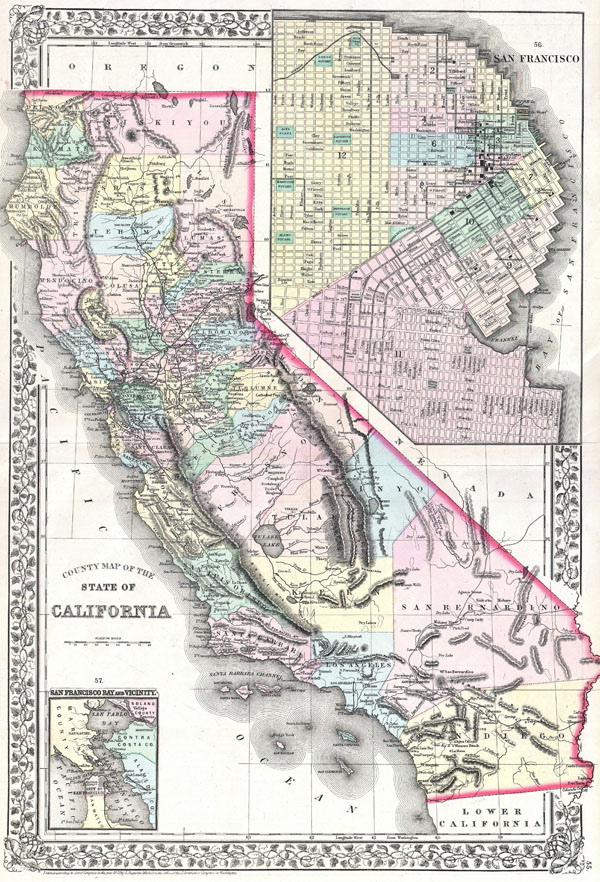
County Map of the State of California.
1772 (dated) 21.5 x 15 in (54.61 x 38.1 cm)
1772 (dated) 21.5 x 15 in (54.61 x 38.1 cm)
Description
A beautiful example of S. A. Mitchell Jr.'s 1872 map of California and San Francisco. Detailed to the county level with attention towns, geographical features, proposed railroads, and cities. Upper right hand quadrant features a large and detailed inset map of San Francisco, labeling individual streets, buildings and railways. Lwoer left features a smaller inset of San Francisco Bay and vicinity. One of the most attractive atlas maps of this region to appear in the mid 19th century. Features the vine motif border typical of Mitchell maps from the 1866-1881. Prepared by S. A. Mitchell for inclusion as plates no. 55 and 56 in the 1872 issue of Mitchell's New General Atlas. Dated and copyrighted, 'Entered according to Act of Congress in the Year 1872 by S. Augustus Mitchell Jr. in the Clerk's Office of the Librarian of Congress at Washington.'
Cartographer
Samuel Augustus Mitchell (March 20, 1792 - December 20, 1868) began his map publishing career in the early 1830s. Mitchell was born in Bristol, Connecticut. He relocated to Philadelphia in 1821. Having worked as a school teacher and a geographical writer, Mitchell was frustrated with the low quality and inaccuracy of school texts of the period. His first maps were an attempt to rectify this problem. In the next 20 years Mitchell would become the most prominent American map publisher of the mid-19th century. Mitchell worked with prominent engravers J. H. Young, H. S. Tanner, and H. N. Burroughs before attaining the full copyright on his maps in 1847. In 1849 Mitchell either partnered with or sold his plates to Thomas, Cowperthwait and Company who continued to publish the Mitchell's Universal Atlas. By about 1856 most of the Mitchell plates and copyrights were acquired by Charles Desilver who continued to publish the maps, many with modified borders and color schemes, until Mitchell's son, Samuel Augustus Mitchell Junior, entered the picture. In 1859, S.A. Mitchell Jr. purchased most of the plates back from Desilver and introduced his own floral motif border. From 1860 on, he published his own editions of the New General Atlas. The younger Mitchell became as prominent as his father, publishing maps and atlases until 1887, when most of the copyrights were again sold and the Mitchell firm closed its doors for the final time. More by this mapmaker...
Source
Mitchell's new general atlas, containing maps of the various countries of the World, plans of cities, etc., (1872 edition).
Condition
Very good condition. Original centerfold.
References
Rumsey 0586.050 (1880 edition), 2483.040 (1870 edition). Bancroft Library: G4360 1879 .M5 / G4360 1870 .M5.