This item has been sold, but you can get on the Waitlist to be notified if another example becomes available, or purchase a digital scan.
1825 Spanish Dirección Hidrográfico Nautical Chart / Map of Baja California
California-cardanobauza-1825$2,500.00

Title
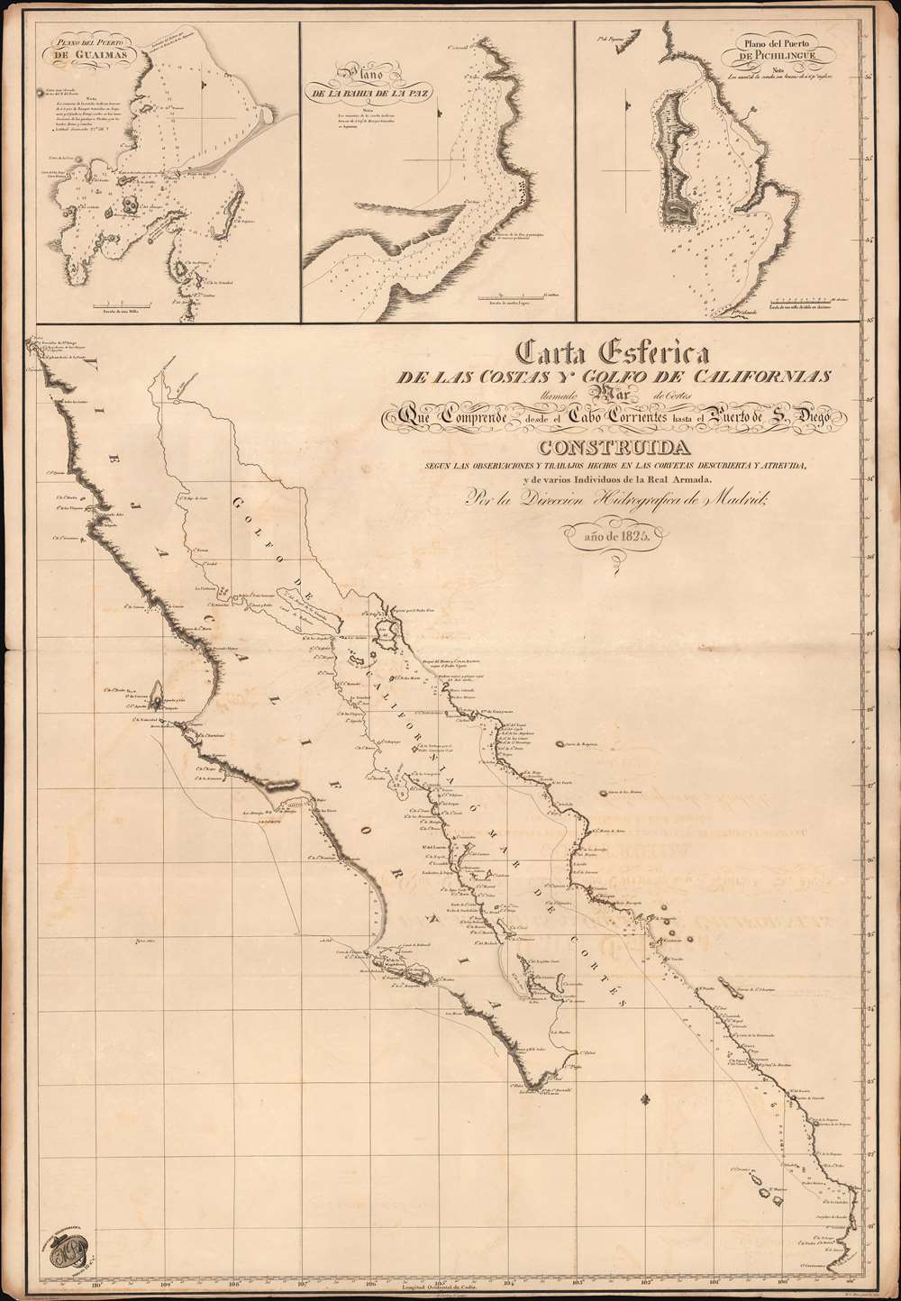
Carta Esferica de las Costas y Golfo de Californias llamado Mar de Cortes Que Comprende desde el Cabo Corrientes hasta el Puerto de S. Diego.
1825 (dated) 34.25 x 23.5 in (86.995 x 59.69 cm) 1 : 2250000
1825 (dated) 34.25 x 23.5 in (86.995 x 59.69 cm) 1 : 2250000
Description
A spectacular 1825 1st edition of the Felipe Cardano y Bauzá / Dirección Hidrográfico foundational nautical chart or maritime map of Baja California and the Gulf of California. This important chart is the basis for much of the subsequent mapping of this region and is reflected in subsequent French and English charts. Coverage extends along the west coast of Mexico from San Diego, California, to Cabo Corrientes, Jalisco, Mexico, including all of modern-day Baja, the Gulf of California, and the Sonora and Sinaloa coasts.
Sources
The cartography here represents Spanish navy hydrography compiled during the Alejandro Malaspina Expedition (1780 - 1794) by the corvettes Descubierta and Atrevida. The cartography dates to about March 1790, when Malaspina reached Mexico and mapped its coasts. As evident here, while the Malaspina Expedition produced new groundbreaking cartography, they did not explore the full extent of the Gulf of California, stopping near Isla Tiburón, with lands to the north only tentatively mapped from older sources. Even in those areas actively mapped by Malaspina, large sections of the coast are ghosted in or only tentatively mapped, underscoring just how little was known of this region even in the early 19th century.The Insets
Three inset maps are featured at top, these include Plano del Puerto de Guimas [1: 50,000], Plano de la Bahia de la Paz [1: 65,000], and Plano del Puerto de Pichilingue [1: 46,000]. Guaymas, Sonora was an important Mexican fort during the Pima Wars, but by the time this map was made, there was but a single inhabitant, 'Tio Pepe' (Uncle Pepe), reportedly a drunk and a thief. Nonetheless, Malaspina must have visited, as Tio Pepe's house is noted in the inset - and in fact, all references to 'Tio Pepe' are likely from Malaspina's records. Both La Paz and Pichilingue are today resort communities in eastern Baja California Sud, not far from Cabo San Lucas. The then newly established town of La Paz is noted.Publication History and Census
This map is the rare first edition of this chart - identifiable by the imprints below the bottom border of the mapmaker Clemente Noguera, the engraver Felipe Cardano y Bauzá, and the letter engraver Máximo Cipriano Maré. The present example was engraved and printed in Madrid, 1825. An entirely new plate for the map was engraved in London by Aaron Arrowsmith as a gift to Guadalupe Victoria (1786 - 1843), first President of the Republic of Mexico, sometime after 1825, but before 1829. The Arrowsmith reissue is rare, but near all known examples in institutional collections seem to correlate to that edition. We have, nonetheless, identified at least two examples of the present edition, both at the National Library of Spain. Unique to the market.CartographerS
Clemente Noguera (fl. c. 1809 – 1860) was a Spanish draftsman, naval pilot, and engraver based in Madrid during the middle part of the 19th century. Little is known of Noguera, but he was active as an engraver as early as 1809, when he engraved a plan of Zaragoza, Spain. He was a second lieutenant of the Spanish Navy in 1830. By, 1850, Noguera was a senior draftsman for the Direccion de Hidrografia. Clemente Noguera should not be confused with Juan Noguera, who was also a senior line-engraver at the Direccion de Hidrografia. The two engravers may or may not be related. Clemente was significantly older than Juan, and may have been an older relative. More by this mapmaker...
Felipe Cardano y Bauzá (1778 - April 15, 1824) was a Spanish engraver, draughtsman, cartographer, engraver, and naval officer active in Madrid. Felipe was born in Cartagena, the son of Marine musician Antonio Cardano and Antonia Bauzá. He studied at the Real Escuela de Navegación de Cartagena, becoming a navy pilot in 1800. In the same year, he relocated to Madrid and began working with the newly created Dirección Hidrográfico. He also enrolled in the Madrid Real Academia de San Fernando. In 1802, he was sent to Paris to study cartographical engraving under the painter and engraver Sébastien-François Bouclet. In 1803, he was promoted to segundo piloto. In 1808, Napoleon Bonaparte (1769 - 1821) invaded Spain, establishing Joseph-Napoléon Bonaparte (1768 - 1844) as King José I of Spain (1808 - 1813). Cardano refused to cooperate with the regime and was imprisoned in Paris. He escaped in April 1814, returning to Spain, where he resumed his work with the Dirección Hidrográfico. His name appears on numerous nautical charts of the period. His personal passion was landscape engraving, and in 1816 he proposed the establishment of a school to that end in Madrid. In 1819 he was appointed custodian of the Real Museo de Pintura established in El Paseo del Prado. He became ill in 1823, and retired to Málaga, where he died one year later. He was a cousin to the illustrious sailor and swashbuckler Felipe Bauzá y Cañas (1764 - 1834). He is the older brother of José María Cardano y Bauzá (1781 - 18??), considered by many to be the father of Spanish lithographic printing. Learn More...
Máximo Cipriano Maré (1775 - 1815) was a Spanish engraver specializing in lettering. Maré was born in Madrid. He worked for the Dirección Hidrográfico / Depósito Hidrográfico until about 1802. From 1802 to 1808 he was with the Imprenta Real, Madrid. Learn More...
The Direccion Hidrografía (1787 - 1927), also known as the Deposito Hydrografico and the Direction de Hidrografía, was the Spanish equivalent of the British Admiralty or the U.S. Coast Survey. This organization, founded in 1787, was commissioned to collect and produce accurate nautical charts of all waters frequented by Spanish vessels. In essence, it replaced the Casa de la Contratación de las Indias (House of Trade of the Indies), which closed its doors in 1790. Like most such organizations, the Direccion Hidrografía marked a new age in cartography. Rather than simply collect charts created by navigators, explorers, and merchants, the Direccion Hidrografía worked closely with naval and military personnel to mount cartographic and hydrographic expeditions in pursuit of the most accurate hydrographical, astronomical, and geodetic measurements. The Direccion Hidrografía created a massive library of nautical charts that, though not nearly as common as similar nautical charts by the U.S. Coast Survey and British Admiralty, are highly desirable for the beauty of their manufacture as well as their accuracy and detail. The office was originally located on Calle Ballesta, but relocated to 36 Alcala, both in Madrid. After 1908 the Dirección was subsumed into other governmental agencies. In 1927 the Direccion was absorbed into the Institute and Observatory of San Fernando, located in Cadiz. The library of original maps, charts, and journals was transferred to the Naval Museum of Madrid - where it resides to this day. Learn More...
Condition
Very good. Some offsetting.