This item has been sold, but you can get on the Waitlist to be notified if another example becomes available, or purchase a digital scan.
1866 Mitchell Map of California
California2-mitchell-1866$100.00

Title
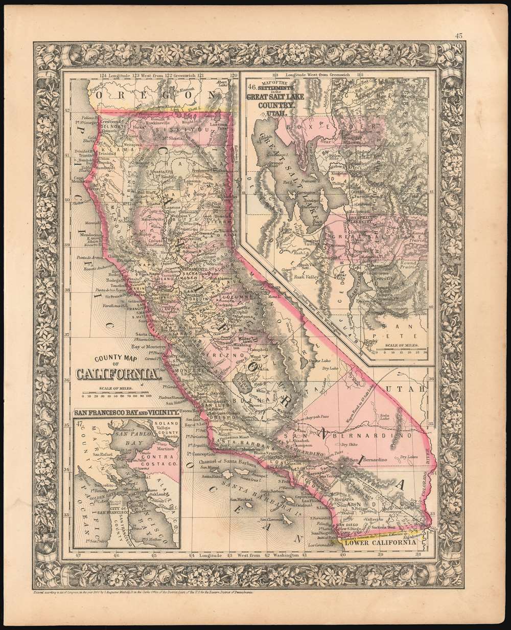
County Map of California.
1866 (dated 1860) 13.5 x 10.75 in (34.29 x 27.305 cm) 1 : 3801600
1866 (dated 1860) 13.5 x 10.75 in (34.29 x 27.305 cm) 1 : 3801600
Description
A scarce 1866 S. A. Mitchell map of California covering not only that state, but also including a detailed inset map of the region surrounding the Great Salt Lake in Utah, showing the settlements there. Another inset, in the lower left quadrant, details San Francisco Bay. Each region is rendered in considerable detail. The map shows the proposed routes for the Southern Pacific and Central Pacific Rail Roads, and includes some of California’s first completed rail lines, connecting Sacramento with Placerville and Marysville. The San Francisco and San Jose Railroad can be seen connecting those two cities, both on the general map and on the detail of the Bay area. The Salt Lake City regional map does not, of course, show railways, but wagon routes between settlements are clearly marked. Topography is indicated with hachures. The map is hand colored, highlighting the map according to county.
Publication History
This plate was created by Mitchell in 1860, and stayed in publication with amendments until 1867, after which point it was replaced by a completely different map. This example features the vine motif border typical of Mitchell maps from the 1865-80 period, and was included as plate 45 in the 1866 edition of Mitchell's New General Atlas. Dated and copyrighted, 'Entered according to Act of Congress in the Year 1860 by S. Augustus Mitchell Jr. in the Clerk's Office of the District Court of the U.S. for the Eastern District of Pennsylvania.'Cartographer
Samuel Augustus Mitchell (March 20, 1792 - December 20, 1868) began his map publishing career in the early 1830s. Mitchell was born in Bristol, Connecticut. He relocated to Philadelphia in 1821. Having worked as a school teacher and a geographical writer, Mitchell was frustrated with the low quality and inaccuracy of school texts of the period. His first maps were an attempt to rectify this problem. In the next 20 years Mitchell would become the most prominent American map publisher of the mid-19th century. Mitchell worked with prominent engravers J. H. Young, H. S. Tanner, and H. N. Burroughs before attaining the full copyright on his maps in 1847. In 1849 Mitchell either partnered with or sold his plates to Thomas, Cowperthwait and Company who continued to publish the Mitchell's Universal Atlas. By about 1856 most of the Mitchell plates and copyrights were acquired by Charles Desilver who continued to publish the maps, many with modified borders and color schemes, until Mitchell's son, Samuel Augustus Mitchell Junior, entered the picture. In 1859, S.A. Mitchell Jr. purchased most of the plates back from Desilver and introduced his own floral motif border. From 1860 on, he published his own editions of the New General Atlas. The younger Mitchell became as prominent as his father, publishing maps and atlases until 1887, when most of the copyrights were again sold and the Mitchell firm closed its doors for the final time. More by this mapmaker...
Source
Mitchell's New General Atlas, containing maps of the various countries of the World, plans of cities, etc., (1867 edition).
Condition
Very good. Very lightly toned.
References
cfRumsey 0565.027 (1860 edition).