This item has been sold, but you can get on the Waitlist to be notified if another example becomes available, or purchase a digital scan.
1849 Mitchell Map of California and Oregon, with Gold Region
CaliforniaGoldOregon2-mitchell-1849$825.00

Title
Oregon, Upper California, and New Mexico.
1849 (dated 1845) 17 x 12.5 in (43.18 x 31.75 cm) 1 : 6705600
1849 (dated 1845) 17 x 12.5 in (43.18 x 31.75 cm) 1 : 6705600
Description
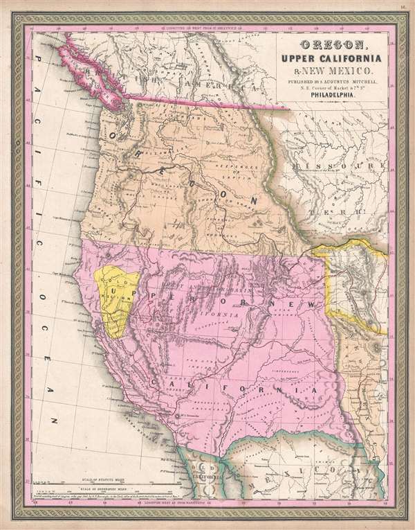
One of the most important mid-19th century American Atlas maps ever published, this is Samuel Augustus Mitchell's 1849 map of Upper California and Oregon, with a highlighted gold region. The map covers from Vancouver to the Mexico border and from the Pacific to Texas. It follows the borders established by the 1848 Treaty of Guadeloupe Hidalgo which formally ended the Mexican American War and ceded Upper California to the United States. It was first issued in 1846 and went through several states, this being the 2nd, and because of the addition of the California Gold Region, and Fremont's cartography, the most desirable.
The California Gold region is highlighted in bright yellow and here appears as such for the first time. Mitchell reworked the plate for this map late in 1849, the first major reworking since the original H.N. Burroughs engraving of 1845. The highlighted California Gold Region exists in only one plate, but appears in two editions of the atlas, late-1849 and early-1850. Late in 1850 the plate was reworked once again, under Cowperthwait, with a more sophisticated mapping of Nevada region, Utah and New Mexico deliniated, and outline and coloring around the gold region removed. The highlighting of Fremont's route was also removed in this late-1850 edition.
Also of significance is the highlighting of routes explored by the Fremont Expedition and the Great Spanish Trail. Although these exploratory routes appear on later editions of the map, it is only in this edition, issued just after Preuss' official map of the expedition, that they are so intensely highlighted. The map adds a wealth of detail from the Fremont Expeditions, particularly in the Great Basin, between Great Salt Lake and the Sierra Nevada Range, where Lake Carson and Walkers Lake appear for the first time. The cartographer has also added hills along Fremont River, and sketched in the course of the Humboldt River.
This map was issued in the 1849 edition of the New Universal Atlas. It was the last edition of that atlas to be published by Mitchell prior to selling the plates and rights to the atlas to Thomas Cowperthwait in 1850.
CartographerS
Samuel Augustus Mitchell (March 20, 1792 - December 20, 1868) began his map publishing career in the early 1830s. Mitchell was born in Bristol, Connecticut. He relocated to Philadelphia in 1821. Having worked as a school teacher and a geographical writer, Mitchell was frustrated with the low quality and inaccuracy of school texts of the period. His first maps were an attempt to rectify this problem. In the next 20 years Mitchell would become the most prominent American map publisher of the mid-19th century. Mitchell worked with prominent engravers J. H. Young, H. S. Tanner, and H. N. Burroughs before attaining the full copyright on his maps in 1847. In 1849 Mitchell either partnered with or sold his plates to Thomas, Cowperthwait and Company who continued to publish the Mitchell's Universal Atlas. By about 1856 most of the Mitchell plates and copyrights were acquired by Charles Desilver who continued to publish the maps, many with modified borders and color schemes, until Mitchell's son, Samuel Augustus Mitchell Junior, entered the picture. In 1859, S.A. Mitchell Jr. purchased most of the plates back from Desilver and introduced his own floral motif border. From 1860 on, he published his own editions of the New General Atlas. The younger Mitchell became as prominent as his father, publishing maps and atlases until 1887, when most of the copyrights were again sold and the Mitchell firm closed its doors for the final time. More by this mapmaker...
Horatio Nelson Burroughs (June 28, 1812 - August 23, 1896) was an engraver and later a banker based in Pennsylvania and active in the early 19th century. He was born in Washington Crossing, New Jersey. Burroughs' work first appears in conjunction with Henry Schenk Tanner and Samuel Augustus Mitchell (the elder). His name appears on the 1846 copyrights of many of Mitchell's earliest and most important atlas and pocket maps. Following 1846, Burroughs retired from engraving to become a banker, eventually becoming president of Commonwealth Bank. He married first Eleanor Douglas Mitchell (18?? - 1853), then, after her untimely death, her sister Caroline Mitchell (1818 - 1892), both daughters of map and atlas publisher Samuel Augustus Mitchell Sr. (1792 - 1868). Learn More...
Source
Mitchell, S. A., A New Universal Atlas, (S. A. Mitchell; Philadelphia) 1849.
The New Universal Atlas is one of the great American atlases of the mid-19th century. Samuel Augustus Mitchell first issued the atlas in 1846 when he acquired the map plates and copyright for Tanner's New Universal Atlas from its publisher, Carey and Hart. The first transitional 1846 edition was published jointly with Carey and Hart, but a second edition was published in the same year with the Tanner imprint erased. This edition of the atlas also introduced the signature S. A. Mitchell green and pink color scheme. Most of the maps from the early editions of the atlas were engraved by H. N. Burroughs or C. S. Williams, often bearing their copyright. Burroughs maps also tended to have what map collector David Rumsey refers to as the 'Cary and Hart' borders, which featured a narrow vine motif. These borders were replaced, along with the Burroughs imprint, with the more traditional Mitchell strap work border used in the atlases until 1856. Mitchell published editions until late in 1850, when he sold the rights to Thomas, Cowperthwait and Company of Philadelphia. Under Cowperthwait, the atlases continued to be published and bear the Mitchell name until 1856, when the plates were again sold, this time to Charles Desilver. Desilver reworked the plates with new border art and a revised color scheme in the style of J. H. Colton. Desilver issued editions from 1857 to 1860, when the atlas was phased out in favor of Samuel Augustus Mitchell Jr.'s New General Atlas.
Condition
Very good condition. Blank on verso. Bright and clean.
References
Rumsey 4835.048. Wheat, C. I., Mapping of the Transmississippi West, 1540 – 1861, 683. Wheat, C. I., The Maps of the California Gold Region, 1848-1857, a Biblio-Cartography of an Important Decade, 168. Moffat, R. M., Printed maps of Utah to 1900, 22. Phillips (Atlases) 797.