1852 Meyer Map of the Western United States
CaliforniaOregonUtah-meyer-1852$500.00

Title
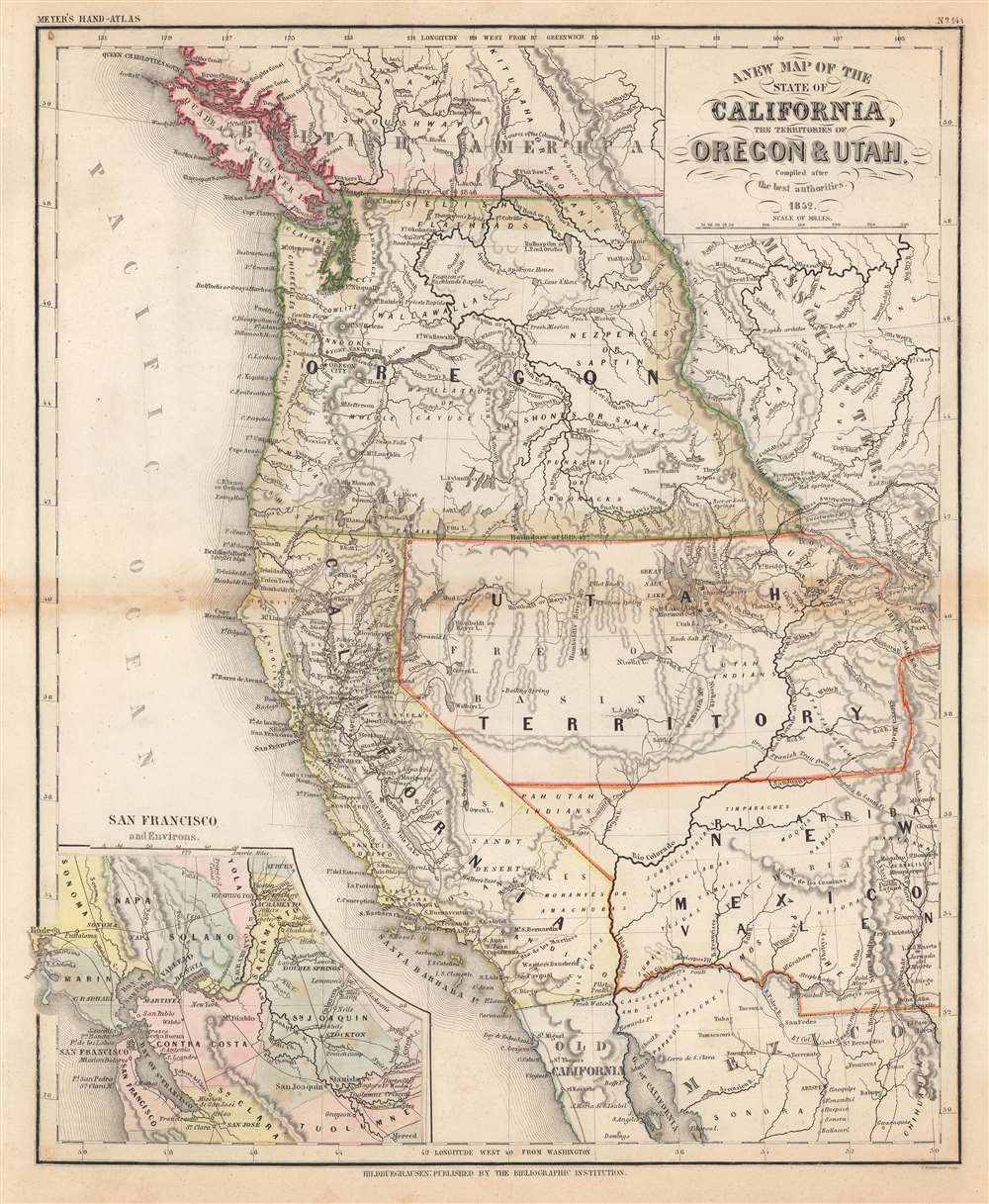
A New Map of the State of California, the Territories of Oregon and Utah.
1852 (dated) 15.75 x 13 in (40.005 x 33.02 cm) 1 : 6700000
1852 (dated) 15.75 x 13 in (40.005 x 33.02 cm) 1 : 6700000
Description
This is an 1852 Joseph Meyer map of California and the territories of Utah and Oregon two years after California became a state. California's borders are recognizable being roughly the same as today. The Oregon Territory stretches from the Pacific Ocean to the Rocky Mountains, and the Utah Territory reaches from the modern-day California-Nevada border to Long's Peak, Colorado. The lower portion of Nevada and Utah were then part of the New Mexico Territory. Settlements are labeled throughout, including those of First Peoples nations.
The 'German Mitchell' and One Key Difference
Often referred to as the 'German Mitchell', Meyer's includes an inset of the California Gold Region in the lower-left, a detail not included in Mitchell's maps. This inset details the San Francisco Bay Area as far east as Sacramento and labels Sutter's Fort, not far from Sutter's Mill, where gold was discovered in 1849.California Gold Rush
The discovery of gold at John Sutter's mill by James Wilson Marshall in January of 1848 was one of the most definitive moments in American history. Coming at the end of the Mexican-American War, the timing of the discovery could not have been more propitious. The combination of new seemly unlimited territory and the lure of gold lead to a literal stampede of adventurers, prospectors, merchants, and homesteaders ready to take their chance for a new prosperous life on the frontier. Moreover, the Gold Rush was not limited to Americans crossing the Great Plains. European, Australian, and even Chinese immigrants rushed into California hungry for their part of the great strike. This Great Migration of peoples transformed the United States in the span of just a few years from a former colony into an expansive transcontinental nation on the cusp of becoming a world power.Publication History and Census
This map was created by E. Biedermann and published by the Bibliographic Institution in Hildburghausen in Meyer's Hand-Atlas as page 144 in 1852. This map is well represented in institutional collections, including (among others) the David Rumsey Map Collection.Cartographer
Joseph Meyer (May 9, 1796 - June 27, 1856) was a German industrialist, merchant, and publisher, active in Germany in the early to mid 19th century. He is best known for publishing the encyclopedia Meyers Conversation-Lexicon. Born in Gotha, Germany, Meyer was educated as a merchant in Frankfurt am Main. He moved to London in 1816, but returned to Germany in 1820 after his stock speculations and business adventures fell through. Once back in Germany, he began by investing in the textile trade (1820 - 24). Meyer began creating business plans concerning how to start railways soon after the first steam-hauled railway began operation in December 1835. He founded the Deutsche Eisenbahnschienen-Compangie auf Actien (German Railway Rail joint stock company) in 1845. Meyer also found great success as a publisher, utilizing the system of serial subscriptions to publications, a new idea for the time. He founded a company, Bibliographisches Institut in Gotha in 1825, which published several versions of the Bible, works of classical literature, atlases, the world in pictures on steel engravings, and an encyclopedia. He moved the Institut from Gotha to Hildburghausen in 1828. He published several atlases, including Meyer's Groẞer Hand-Atlas (1843 - 1860). In 1848, he supported the Springtime of the Peoples Revolutions that took place throughout Germany and much of Europe. When the revolutions failed in 1849, Meyer was briefly imprisoned for his support of revolutionary activities. The revolutions also began to take a toll on Meyer's business interests, and when he died, in 1856, the Bibliographisches Institut was struggling financially. His son, Herrmann Julius Meyer, took over the firm, spearheading a rapid recovery. This, and other businesses prospered under Herrmann Julius (April 4, 1826 - March 12, 1909) and when he died in 1909, he led the richest family in Saxony, with more total wealth than the King of Saxony More by this mapmaker...
Condition
Very good. Light toning along original centerfold.
References
Rumsey 4807.166. OCLC 1005671439, 632925160. Not in Wheat.