This item has been sold, but you can get on the Waitlist to be notified if another example becomes available, or purchase a digital scan.
1880 Depot de la Marine Map of Cambodia - Bankgok to Saigon
Cambodia-depotdelamarine-1880$475.00

Title
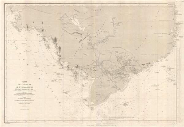
Carte de la Presqu'ile de l'Indo-Chine, depuis le port de Qui- Nhon dans le mer de Chine jusqu'à l'entrée de la Rivière de Bang-Kok dans le Golfe de Siam.
1880 (dated) 26 x 37 in (66.04 x 93.98 cm) 1 : 1000000
1880 (dated) 26 x 37 in (66.04 x 93.98 cm) 1 : 1000000
Description
An extremely uncommon 1880 nautical chart or maritime map of Cambodia by the French hydrographic service, the Dépot des Cartes et Plans de la Marine. First issued in 1865, with updates to 1880, this map is roughly centered on the Cambodian capital of Phnom Penh. The map covers from Bangkok and the Bay of Siam, eastward as far as the South China Sea and the Vietnamese port of Qui Nhơn. Unlike many nautical charts, the present chart offers excellent inland detail, most likely because of the vast array of navigable inland rivers that spider web through the region. Numerous communities and cities are identified, as are the ruins of Angkor Wat, navigable canals, and overland caravan routes from Bangkok (Thailand) and Saigon (Ho Chi Min City, Vietnam).
This map was made at the request of the French Emperor Napoleon III, whose government was increasingly active in this region. In 1863, just 2 years before the first edition of this map was prepared, the Cambodian king Norodom had requested the establishment of a French protectorate over his country. In 1867, Siam (modern Thailand) renounced suzerainty over Cambodia and officially recognized the French protectorate on Cambodia, in exchange for the control of Battambang and Siem Reap, provinces which officially became part of Thailand. (These provinces would be ceded back to Cambodia by a border treaty between France and Siam in 1906). The established border appears on this map. The formation of French Indochina in the subsequent decades had a lasting effect on the region.
This map was issued by the Dépot des Cartes et Plans de la Marine based upon French surveys completed by M. Manen and British Surveys, for the Gulf of Siam, completed by the British Captain Richards. It was engraved by H. Lansraux and printed by Charles Dyonnet in Paris. While we have been able to identify a few institutional examples, this map is rare by any measure and has no market history.
CartographerS
Dépôt des Cartes et Plans de la Marine (fl. 1720 - present), often called the Dépôt de Marine, was a French hydrographic mapping organization founded in 1720 under Charles-Hercule of Albert de Luynes (1674 - 1734). Much like the U.S. Coast Survey, the British Admiralty, and the Spanish Deposito Hydrografico, the Dépôt was initiated as a storehouse and distribution center of existing nautical and marine charts. Eventually the Dépôt initiated its own mapping activities in an attempt to improve and expand upon existing material. Some of the more prominent cartographers and hydrographers associated with the of Dépôt des Cartes were, Philippe Buache, Jacques-Nicholas Bellin, Giovanni Rizzi-Zannoni, Rigobert Bonne, and Jean Nicolas Buache. More by this mapmaker...
Charles Dyonnet (fl. c. 1822 - c. 1880) was an extremely active Paris based engraver working in the mid to late 19th century. From his offices at 220 Rue St. Jacques, Paris, Dyonnet engraved numerous maps for many of the most prominent 19th French cartographic publishers including Vuillemin, Dufour, Fremin and Duvotenay. From 1850-1861, he held the coveted position of "Graveur du Dépot de la Marine," and in this position engraved numerous French naval and military maps. Dyonnet had a detail oriented and aesthetically minded hand and is responsible from some of the most beautiful French maps to emerge during the 19th century. Learn More...
Condition
Very good. Slight overall toning.
References
National Library of Australia, MAP RM 4651. OCLC 897474393.