This item has been sold, but you can get on the Waitlist to be notified if another example becomes available, or purchase a digital scan.
1878 Mason Plan or Map of Cambridge, Massachusetts
Cambridge-mason-1878$425.00

Title
Plan of Cambridge.
1878 (dated) 18 x 26.5 in (45.72 x 67.31 cm) 1 : 10560
1878 (dated) 18 x 26.5 in (45.72 x 67.31 cm) 1 : 10560
Description
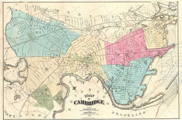
This is a scarce and beautiful 1878 map of the city of Cambridge Massachusetts by W. A. Mason and Sons. Centered on Harvard College, cover Cambridge north of the Charles River extending from Fresh Pond to what is today Gilmore Bridge (Prison Point Bridge at the time). The map is color-coded according to wards and notes radical distances from City Hall. Incredibly detailed, parks, streets, important buildings, ponds, and railroads are also noted. Shows the proposed extensions in the east.
This map was prepared by W. A. Mason and Sons. Copyrighted by W. A. Greenough in 1877, this is the 1878 edition published by Greenough and Company. We only know of two editions of this map ever issued – the first in 1878 and the second in 1881. Furthermore, only two known examples of this particular 1878 edition are known, one with Harvard College Library and the other with the University of Massachusetts, Amherst, making this a scarce find.
This map was prepared by W. A. Mason and Sons. Copyrighted by W. A. Greenough in 1877, this is the 1878 edition published by Greenough and Company. We only know of two editions of this map ever issued – the first in 1878 and the second in 1881. Furthermore, only two known examples of this particular 1878 edition are known, one with Harvard College Library and the other with the University of Massachusetts, Amherst, making this a scarce find.
Cartographer
Rand, McNally and Co. (fl. 1856 - present) is an American publisher of maps, atlases and globes. The company was founded in 1856 when William H. Rand, a native of Quincy, Massachusetts, opened a print shop in Chicago. Rand hired the recent Irish immigrant Andrew McNally to assist in the shop giving him a wage of 9 USD per week. The duo landed several important contracts, including the Tribune's (later renamed the Chicago Tribune) printing operation. In 1872, Rand McNally produced its first map, a railroad guide, using a new cost effective printing technique known as wax process engraving. As Chicago developed as a railway hub, the Rand firm, now incorporated as Rand McNally, began producing a wide array of railroad maps and guides. Over time, the firm expanded into atlases, globes, educational material, and general literature. By embracing the wax engraving process, Rand McNally was able to dominate the map and atlas market, pushing more traditional American lithographic publishers like Colton, Johnson, and Mitchell out of business. Eventually Rand McNally opened an annex office in New York City headed by Caleb S. Hammond, whose name is today synonymous with maps and atlases, and who later started his own map company, C. S. Hammond & Co. Both firms remain in business. More by this mapmaker...
Condition
Very good. Minor wear along original fold lines. Minor spotting, especially near left margin. Professionally flattened and backed with archival tissue.
References
OCLC: 46567898.