1885 Poole Bird's-Eye View of Camp Framingham, Massachusetts
CampFramingham-poole-1885$750.00

Title
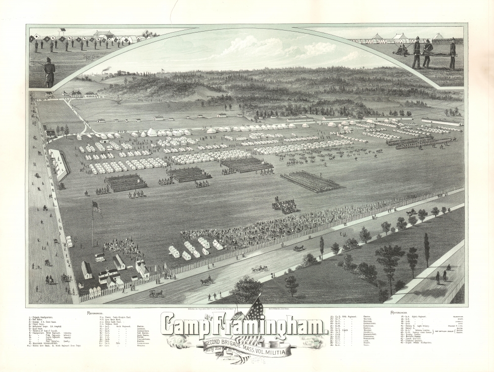
Camp at Framingham. Second Brigade. Mass. Vol. Militia. July 21st to 25th 1885.
1885 (dated) 19.5 x 25 in (49.53 x 63.5 cm)
1885 (dated) 19.5 x 25 in (49.53 x 63.5 cm)
Description
This is an 1885 Albert F. Poole bird's-eye view of Camp Framingham, Massachusetts, a former Massachusetts National Guard camp in Framingham.
A Closer Look
The view depicts training exercises undertaken by the Second Brigade of the Massachusetts Volunteer Militia. Individual tents are illustrated and numbered to correspond with an index along the bottom border - readers could identify their own tents! The hospital, ambulance corps, signal corps, headquarters, and individual tents for the regiments involved are named. Several units are actively engaged in organized drills, possibly for the entertainment and education of the spectators along the fence. Passers-by, either on foot or in carriages, appear along the roads that encircle the camp. Views of the Signal Corps and the Ambulance Corps doing their assigned tasks are situated in the upper left and right corners, respectively.Camp Framingham
Camp Framingham was a Massachusetts National Guard Camp in Framingham, Massachusetts, in use from 1873 until 1944. It was also known Camp or Fort Dalton. The camp served as a mobilization station during the Spanish-American War, the build-up along the U.S.-Mexico border in 1916, and during the summer of 1917 to send soldiers overseas to fight during World War I (1914 - 1918). It gained new monikers during the Spanish-American War when it was known as both Camp McGuinness and Camp Dewey. The base served as Headquarters for the 181st Infantry Regiment from May 1942 until December 1943, then the regiment and its companies served on coast patrol duty. The base was transferred to the Massachusetts State Police in 1948, and parts of it are still used by the Massachusetts State Police and the Massachusetts Emergency Management Agency.Chromolithography
Chromolithography is a color lithographic technique developed in the mid-19th century. The process involved using multiple lithographic stones, one for each color, to yield a rich composite effect. Oftentimes, the process would start with a black basecoat upon which subsequent colors were layered. Some chromolithographs used 30 or more separate lithographic stones to achieve the desired effect. Chromolithograph color could also be effectively blended for even more dramatic results. The process became extremely popular in the late 19th and early 20th centuries, when it emerged as the dominate method of color printing. The vivid color chromolithography produced made it exceptionally effective for advertising and propaganda imagery.Publication History and Census
This view was published by Albert F. Poole in 1885 and lithographed by George H. Walker and Company of Boston. One example is cataloged in OCLC and is part of the collection at the State Library of Massachusetts. We located a second example in the Leventhal Map Collection at the Boston Public Library.CartographerS
Albert 'Bert' Poole (1853 - November, 1934) was an American painter, cartoonist, and viewmaker active in New England during the late 19th and early 20th centuries. Pool was born in Brockton (North Bridgewater), Mass. and was responsible for at least 46 town views published between 1880 and 1905. Early in his career he worked as a clerk and school principle. He turned his attention to the visual arts in 1880, when is fist city view, Bar Harbor Maine, was published by J. J. Stoner. He partnered with another view maker George E. Norris (1855 - 1926), in 1993, published as 'Poole and Norris.' Around the turn of the century, he began publishing under the imprint of 'Bert Poole Co. Boston.' He is known for having a distinctive style employing decorative borders, attractive titles, and vignette imagery. He frequently used a gravure technique, imparting on his images a graduated tonal effect. This is some confusion regarding his death date. Some references (Reps) identify it as 1834, others, 1839. His obituary in the Boston Globe confirm a November 1934 death. More by this mapmaker...
George Hiram Walker (January 4, 1852 - November 14, 1927) was a Boston based publisher of books, views, and maps active in the late 19th and early 20th centuries. Born in Springfield, Vermont, Walker started his life as a dry goods merchant but developed an active interest in publishing during the early 1870s. Walker began publishing in 1878 when he partnered with an unknown New York Firm. Two years later, Walker brought the operation in house by partnering with his brother, Oscar W. Walker, in the opening of a lithography studio at 81 Milk Street, Boston. Shortly thereafter the firm expanded to new offices at 160 Tremont Street, Boston. The Walker brothers produced a large corpus of works, most of which focused on travel and tourism in New England. Walker also established the Walker-Gordon Milk Laboratory with Dr. Thomas Morgan Rotch and Gustave Gordon. This interesting investment was based on the premise that infant deaths could be avoided by providing higher quality milk. The company eventually became a great success, producing a high-quality cow milk that closely resembled human breast milk. In the process the Walker-Gordon laboratory developed many of the dairy health standards that are still with us today. Walker married Irene L. Loud on March 25, 1885. Learn More...
Condition
Very good. Closed tear extending one and one half inches (1.5) from top margin professionally repaired on verso. Does not effect printed area. Exhibits soiling from previous framing on verso that does not effect the printed image on front. Blank on verso.
References
Boston Public Library, Leventhal Collection, G3764.F7A3 1882 .P6. OCLC 843945832.