This item has been sold, but you can get on the Waitlist to be notified if another example becomes available, or purchase a digital scan.
1844 Black Map of Canada : Ontario and Quebec
Canada-black-1844$75.00

Title
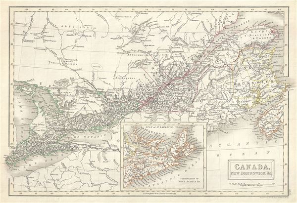
Canada, New Brunswick etc.
1844 (undated) 11 x 16 in (27.94 x 40.64 cm) 1 : 4100000
1844 (undated) 11 x 16 in (27.94 x 40.64 cm) 1 : 4100000
Description
This is a fine example of Adam and Charles Black's 1844 map of Quebec (Canada East or Lower Canada) and New Brunswick. The map covers from Essex to Cape Breton Island in Nova Scotia (shown via inset at bottom center). It includes Upper and Lower Canada (Ontario and Quebec), New Brunswick and Nova Scotia. Also shows the Great Lakes Ontario, Erie and Huron. An inset map near the bottom margin of the map details Nova Scotia, Cape Breton Island and Prince Edward Island. Throughout, the map identifies various cities, towns, rivers and an assortment of additional topographical details.
Canadian provinces and territories were under British and French control from the 16th century, until France gave up its claims in the Treaty of Paris in 1763. Canada would remain a collection of British colonies until its confederation in 1867, when the British Province of Canada was divided into Quebec and Ontario and the British colonies of New Brunswick and Nova Scotia incorporated as Canadian provinces. This map was drawn during the time following the Canadian Rebellions of 1837 against the British Empire, which led to a single colony of the United Province of Canada and the adoption of representative government by 1848. The map was engraved by S. Hall and issued as plate no. XLVI in the 1844 edition of Black's General Atlas.
Canadian provinces and territories were under British and French control from the 16th century, until France gave up its claims in the Treaty of Paris in 1763. Canada would remain a collection of British colonies until its confederation in 1867, when the British Province of Canada was divided into Quebec and Ontario and the British colonies of New Brunswick and Nova Scotia incorporated as Canadian provinces. This map was drawn during the time following the Canadian Rebellions of 1837 against the British Empire, which led to a single colony of the United Province of Canada and the adoption of representative government by 1848. The map was engraved by S. Hall and issued as plate no. XLVI in the 1844 edition of Black's General Atlas.
CartographerS
Charles and Adam Black (fl. 1807 - present) were map and book publishers based in Edinburgh. Charles and his uncle, Adam, both of Edinburgh, Scotland, founded their publishing firm in 1807. They published a series of maps and atlases throughout the 19th century. In addition to an array of atlases, the Black firm is known for their editions of the Encyclopedia Britannica (1817 - 1826) and the first publishing of Sir Walter Scott's novels in 1854. In 1889 the A. & C. Black publishing house moved to London where it remains in operation to this day. More by this mapmaker...
Sidney Hall (1788 - 1831) was an English engraver and map publisher active in London during the late 18th and early 19th centuries. His earliest imprints, dating to about 1814, suggest a partnership with Michael Thomson, another prominent English map engraver. Hall engraved for most of the prominent London map publishers of his day, including Aaron Arrowsmith, William Faden, William Harwood, and John Thomson, among others. Hall is credited as being one of the earliest adopters of steel plate engraving, a technique that allowed for finer detail and larger print runs due to the exceptional hardness of the medium. Upon his early death - he was only in his 40s - Hall's business was inherited by his wife, Selina Hall, who continued to publish under the imprint, "S. Hall", presumably for continuity. The business eventually passed to Sidney and Selina's nephew Edward Weller, who became extremely prominent in his own right. Learn More...
Source
Black, A. and C., Black's General Atlas (Edinburgh), 1844.
Black's General Atlas was a popular Scottish atlas of the world issued by the Edinburgh firm of Adam and Charles Black. This atlas was first issued in 1840 with subsequent editions being printed well into the 1890s. While most editions were printed in Edinburgh, an American edition was issued in 1857. Most early editions of his atlas were engraved by S. Hall. Typically this refers to Sidney Hall, who died in 1831, but in this case, since the engraving was initiated well after his death, it was most likely his widow, Selina Hall, who did the engraving. Later editions feature additional maps updated and engraved by William Hughes. Early editions featured outline color only, but later editions embraced a full color approach with pale green, yellow, and blue pastels. All editions are known for their meticulous presentation of the most up-to-date cartographic information. Moreover, this exceptionally long publication run provides a fine cartographic record of the middle to late 19th century - particularly as regards the complex cartographic evolution of the Americas through this period.
Condition
Very good. Original platemark visible. Blank on verso.
References
Rumsey 2305.054 (1854 edition). Philips (atlases) 4334.