This item has been sold, but you can get on the Waitlist to be notified if another example becomes available, or purchase a digital scan.
1893 Rand McNally Map of Canada or British America
Canada-randmcnally-1893$50.00

Title
Map of British America.
1893 (undated) 13.5 x 20.5 in (34.29 x 52.07 cm) 1 : 14000000
1893 (undated) 13.5 x 20.5 in (34.29 x 52.07 cm) 1 : 14000000
Description
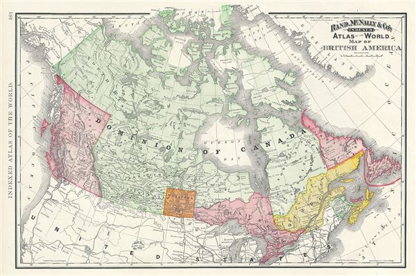
A beautiful example of Rand McNally and Company's 1893 map of British America or Canada. The map covers the entire region from Victoria Island to Lake Erie and from the Pacific Ocean and Queen Charlotte Islands (Haida Gwaii) to Newfoundland. Manitoba at the time was much smaller that its current size and was known as the 'postage stamp province.'
Canadian provinces and territories were under British and French control from the 16th century, until France gave up its claims in the Treaty of Paris in 1763. Canada would remain a collection of British colonies until its confederation in 1867, when the British colonies of New Brunswick and Nova Scotia would become Canadian provinces along with Ontario and Quebec. Although known as the 'Birthplace of Confederation,' Prince Edward Island would only join the confederation in 1873. Although the region suffered economically during the recession of 1893, Ontario continued to flourish in mineral exploitation and industry.
Color coded according to regions and territories, the map notes several towns, cities, rivers, mountains, and various other topographical details with relief shown by hachure. This map was issued as plate no. 361 in the 1893 issue of Rand McNally and Company's Indexed Atlas of the World - possibly the finest atlas Rand McNally ever issued.
Cartographer
Rand, McNally and Co. (fl. 1856 - present) is an American publisher of maps, atlases and globes. The company was founded in 1856 when William H. Rand, a native of Quincy, Massachusetts, opened a print shop in Chicago. Rand hired the recent Irish immigrant Andrew McNally to assist in the shop giving him a wage of 9 USD per week. The duo landed several important contracts, including the Tribune's (later renamed the Chicago Tribune) printing operation. In 1872, Rand McNally produced its first map, a railroad guide, using a new cost effective printing technique known as wax process engraving. As Chicago developed as a railway hub, the Rand firm, now incorporated as Rand McNally, began producing a wide array of railroad maps and guides. Over time, the firm expanded into atlases, globes, educational material, and general literature. By embracing the wax engraving process, Rand McNally was able to dominate the map and atlas market, pushing more traditional American lithographic publishers like Colton, Johnson, and Mitchell out of business. Eventually Rand McNally opened an annex office in New York City headed by Caleb S. Hammond, whose name is today synonymous with maps and atlases, and who later started his own map company, C. S. Hammond & Co. Both firms remain in business. More by this mapmaker...
Source
Rand McNally & Co., Rand, McNally & Co's Indexed Atlas of the World, (Chicago) 1893.
Condition
Very good. Map of British Columbia on verso.
References
Rumsey 2094.008 (1889 edition). Philip (atlases) 952.