This item has been sold, but you can get on the Waitlist to be notified if another example becomes available, or purchase a digital scan.
1807 Cary Map of Canada and the Great Lakes
CanadaGreatLakes-cary-1807$225.00

Title
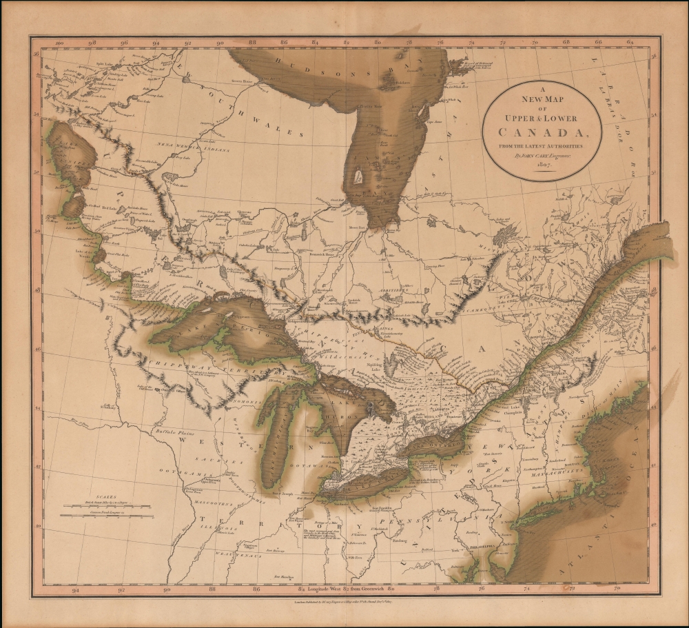
A New Map of Upper and Lower Canada, from the latest authorities.
1807 (dated) 20 x 21.5 in (50.8 x 54.61 cm) 1 : 2300000
1807 (dated) 20 x 21.5 in (50.8 x 54.61 cm) 1 : 2300000
Description
This the first edition of John Cary's 1807 map of Canada and the Great Lakes. The map reflects the post-Revolutionary War period when Britain refocused its attention on developing its Canadian colonies. Meanwhile, the United States, following the expedition of Lewis and Clark, was about to begin its first major phase of westward expansion. Within Canada, the rivalry between the well-established fur-trading Hudson Bay Company and the upstart Northwest Company was heating up as both competed for valuable trade routes.
A Closer Look
Coverage focuses on Ontario and Quebec, including the St. Lawrence valley, the Great Lakes, and river connections to Lake of the Woods and Like Winnipeg. Hudson Bay looms to the north. The attention here is on the Winnipeg-Great Lakes-St. Lawrence corridor, a vital and well traveled artery of the Fur Trade, the driving force of the Canadian interior. There are few roads, but river courses are noted, in some cases with milage. Several 'houses,' essentially frontier way stations for trappers and explorers are identified: Fredrick, Brunswick, Osnaburgh, and Chatham, among othersGreat Lakes
The Great Lakes are bisected between the United States and Canada along lines defined at the end of the American Revolutionary War (1775 - 1783). Curiously, Cary retains the phantom islands in Lake Superior ('Philippeaux' and 'Maruepas') proposed in 1744 by Charlevoix and Bellin and which maintained such cartographic integrity that they were used as boundary demarcations in the 1783 Treaty of Paris. Eventually, Isle Philippeaux disappeared from maps entirely and nearby (factual) Isle Royal became part of the United Sates. Curiously, the coloration also suggests some ambiguity over the US-Canada border east of the Great Lakes, with one border following the St. Lawrence and another border located well to the south.Publication History and Census
This map was engraved 1807 and published by John Cary for his Cary's New Universal Atlas. It is the first edition. Subsequent editions followed in updated versions of the atlas in 1811 and 1819.Cartographer
John Cary (1754 - 1835) was a London based cartographer active in the early part of the 19th century. Ronald Vere Tooley, the prominent English map historian, writes of Cary, "As an engraver he was elegant and exact with fine clear lettering and great delicacy of touch." Cary began his work as an engraver, cartographer, and globe maker in 1776 with his New and Correct English Atlas. This important atlas represented a new phase in cartography where accuracy and detail rose in prominence over the decorative embellishments of the 18th century. This change was indicative of the times when travel and commerce were expanding globally as never before. Cary's mastery of both engraving and cartography resulted in a series of seminal works that redefined mapmaking in the early 19th century. His stupendous Cary's New Universal Atlas, published in 1808, set the standard for all cartographers who followed. Cary reissued this seminal atlas in 1811, 1819, 1824, 1828, 1833, 1836 and 1844. Cary also did considerable work on the English Ordinance Survey prior to 1805. His cartographic work particularly inspired the Edinburgh school of cartography as represented by John Pinkerton and John Thomson. In America, Cary's work was used as the basis for Tanner's important New American Atlas. Cary's last published atlas appeared posthumously in 1844, however, by 1850 Cary's work was being carried on by his sons and other well-known cartographers including James Wyld, John Tallis & Company, and Crutchley. More by this mapmaker...
Source
Cary, J., Cary's New Universal Atlas, (London) 1808.
Condition
Good. Even overall toning. Slight wear on centerfold. Color attractively oxidized.
References
Winearls, J., Mapping Upper Canada 1780-1867, #35. Phillips (America), page 194. OCLC 28923599. Rumsey 1657.055.