This item has been sold, but you can get on the Waitlist to be notified if another example becomes available, or purchase a digital scan.
1834 S.D.U.K. Map of the United States and Canada
CanadaUnitedStates-sduk-1834$62.50

Title
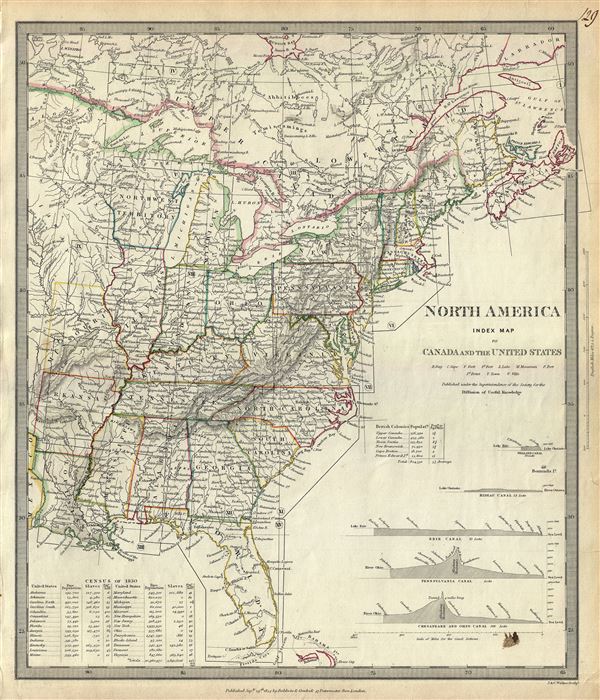
North America Index Map to Canada and the United States.
1834 (dated) 16 x 13.5 in (40.64 x 34.29 cm) 1 : 8700000
1834 (dated) 16 x 13.5 in (40.64 x 34.29 cm) 1 : 8700000
Description
An uncommon 1834 map of the United States issued by the S.D.U.K. Parts of Canada are also included. The map covers the United States east of the Mississippi as well as the Trans-Mississippi territories of Louisiana, Arkansas and Missouri. Several Indian tribes are identified, including the Chippeways, Sioux, Foxes, and others. Wisconsin and Iowa are shown with amorphous boundaries. Most of what is today Wisconsin is identified as 'Northwest Territory.' The northern boundary of Maine is depicted according to British claims prior to the Treaty of 1842. The map also includes profiles of 5 canals in the lower right quadrant and the United States census of 1830 listing the free and slave population according to states.
The early part of the 19th century witnessed the westward expansion of European-American toward and eventually beyond the Mississippi. Throughout the 1840s emigration and settlement to the west of the Mississippi led to a transformation of the national map.
Published in 1834 by Baldwin and Cradock of Paternoster Row for the Society for the Diffusion of Useful Knowledge, or S.D.U.K. Although the Society formally closed its doors in 1848, subsequent reissues of the S.D.U.K. atlas were printed well into the 1870s by Chapman and Hall, who acquired the original plates.
Cartographer
The "Society for the Diffusion of Useful Knowledge" (1826 - 1848) was a Whiggish organization founded in 1828 at the instigation of idealistic British lord Henry Peter Brougham. The admirable goal of the Society was to distribute useful information via a series of publications to the English working and middle classes. It promoted self-education and the egalitarian sharing of all knowledge. While closely tied to the London University and publishing houses on the order of Baldwin and Cradock, Chapman and Hall, and Charles Knight, the Society failed to achieve its many lofty goals in finally closed its doors in 1848. Most likely the failure of the Society resulted from its publications being too expensive for its intended lower to middle class markets and yet not large and fine enough to appeal to the aristocratic market. Nonetheless, it did manage to publish several extraordinary atlases of impressive detail and sophistication. Their most prominent atlas consisted of some 200 separately issued maps initially published by Baldwin and Cradock and sold by subscription from 1829 to 1844. Afterwards, the Society combined the maps into a single world atlas published under the Chapman and Hall imprint. In its day, this atlas was unprecedented in its quality, scope, and cost effectiveness. Today Society, or S.D.U.K. as it is commonly known, maps are among the most impressive examples of mid-19th century English mass market cartographic publishing available. The S.D.U.K. is especially known for its beautiful and accurately detailed city plans. More by this mapmaker...
Source
Maps of the Society for the Diffusion of Useful Knowledge, (London: Baldwin & Cradock), 1834.
Condition
Very good. Blank on verso. Minor ink stain in bottom right quadrant.
References
Rumsey 0890.127. Phillips (Atlases) 794.