1928 Canadian Pacific Pictorial Map of the Canadian Rocky Mountains
CanadianRockies-canadianpacific-1928$500.00


Title
The Canadian Rockies: Rocky Mountain Park - Yoho Park - Kootenay Park.
1928 (dated) 17.5 x 31.25 in (44.45 x 79.375 cm) 1 : 300000
1928 (dated) 17.5 x 31.25 in (44.45 x 79.375 cm) 1 : 300000
Description
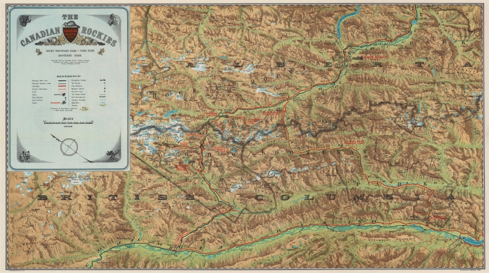
This is a 1928 Canadian Pacific Railway pictorial map of the Canadian Rocky Mountains in Alberta and British Columbia created to cultivate outdoor adventure tourism.
A Closer Look
Oriented toward the east, the Canadian Pacific Railway cuts the mountains. Roads and highways shadow the railroad's route, hinting at the imminent decline of passenger rail travel. An adventurer's playground, the map highlights miles of hiking trails, unobtrusively reinforcing the opportunity available to the outdoor enthusiast. Hotels and campsites are also noted.Canadian Pacific Railway Network Map
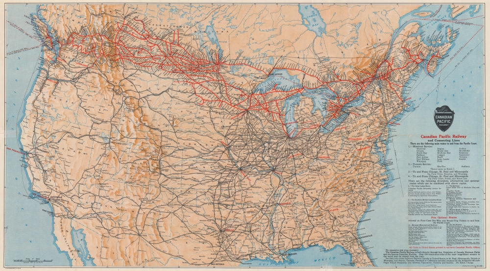
A Canadian Pacific Railway network map occupies the verso. Canadian Pacific's extensive network is highlighted in red, with all stops labeled. Cities within the United States printed in red have Canadian Pacific offices. Major railroads within the United States are traced and labeled, with only major stops identified.Publication History and Census
This map was compiled and drawn under the supervision of Arthur O. Wheeler and published by the Canadian Pacific Railway Company in 1927 and corrected to October 1928. We note five examples cataloged in OCLC: Harvard University, the University of Illinois at Urbana Champaign, the University of California, Santa Barbara, the Library and Archives Canada, and the University of Lethbridge. Scarce on the private market.Cartographer
Arthur Oliver Wheeler (May 1, 1860 - March 20, 1945) was an Irish Canadian surveyor and mountaineer. Born in Lyrath, Ireland, Wheeler attended schools Ballinasloe College in County Galway, Ireland, and Dulwich College in London before moving to Canada in 1876. For the next nine years he worked in midwestern Canada as a surveyor, when, in 1885, he was appointed to the Surveys branch of the Department of the Interior under Dr. Deville. Deville, the originator of Canadian photo-topographical methods, taught Wheeler these methods and how to be a mountain topographer while mapping parts of the Canadian Rocky Mountains. Wheeler then elected to start his own surveying firm in 1890, but by 1893 he had returned to the Department of the Interior. Then, starting in 1895, he began working on surveying projects that lasted almost continuously until 1925 and the completion of the Alb3erta-British Columbia provincial boundary survey. During these thirty years, Wheeler worked on projects for the Canadian Pacific Railway, and he took part in surveying the International Boundary between Alaska and the Yukon Territory, then being arbitrated in London. He returned to private practice in 1910, but remained out of government service only until 1913, when he was named Commissioner for British Columbia on the Interprovincial Boundary Survey, mapping and surveying over 600 miles of the main range Rocky Mountains along the Continental Divide. Wheeler helped found the Alpine Clube of Canada (ACC) and the Canadian Alpine Journal. Wheeler served as President of the ACC from 1906 through 1910, and as Managing Director from 1907 until 1930. Wheeler served as Editor of the Journal until 1926. He was Honorary President of the ACC from 1926 until his death. He married Clara Macoun in 1887, who passed away in 1923. He married Emmeline Savatard in 1924. He had one son. More by this mapmaker...
Condition
Very good. Verso repairs to fold separations. Railroad map of Canada and the United States on verso.
References
OCLC 1007209872.