
This item below is out of stock, but another example (left) is available. To view the available item, click "Details."
Details
1962 Rude Pictorial Map of California and Nevada
$1,000.00
1962 Rude Pictorial Map of California and Nevada
CANV-rude-1962$500.00


Title
California and Nevada : Pano-view Map.
1962 (dated) 31.75 x 23.75 in (80.645 x 60.325 cm) 1 : 1900000
1962 (dated) 31.75 x 23.75 in (80.645 x 60.325 cm) 1 : 1900000
Description
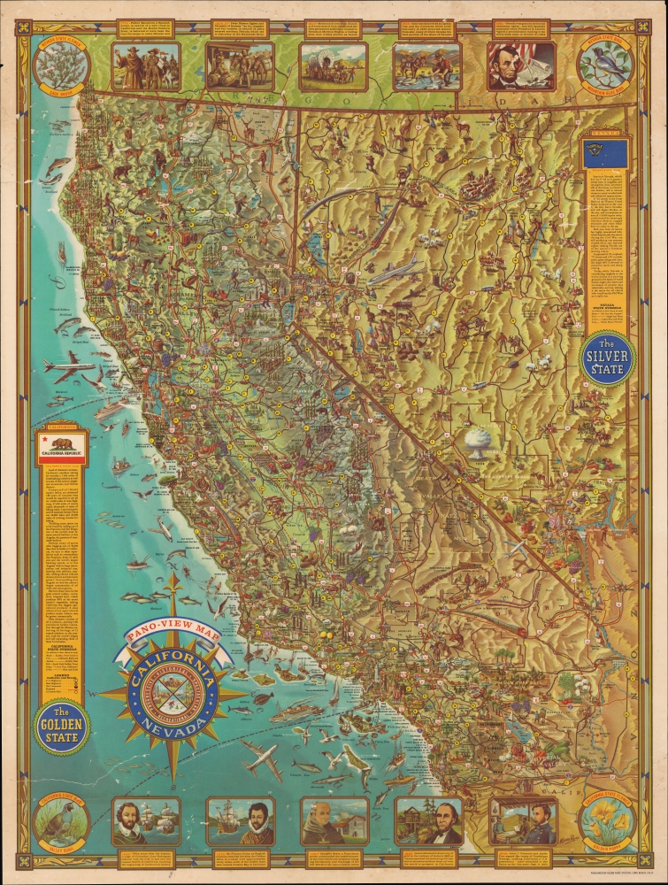
An striking mid-century 1962 pictorial map of California and Nevada, produced by Kleng Rude. It provides a snapshot of the post-World War II (1939 - 1945) regional population boom and its consequent cultural impact.
Highways are labeled throughout, including the recently-designated Interstate-10, running through Arizona to the greater Los Angeles region, and Interstate-80, passing through Reno and Lake Tahoe towards the San Francisco Bay Area. The planned route of Interstate-5, which had only recently begun construction through the Central Valley, is marked with a dotted line.
A banner at top discusses important events in Nevada's history while a box at top-right provides information on its geography, terrain, and economy. A similar banner and box for California appear at bottom and bottom-left, respectively.
A Closer Look
California and Nevada are depicted in vivid color and considerable detail, complete with mountains, waterways, deserts, and forests, including State and National Parks. Many illustrations portray the states' history, economy, wildlife, transportation, leisure activities, and more; these extend from the desert to the mountains and coast and even out into the Pacific Ocean. Especially noticeable is the demarcation of the Las Vegas Bombing and Gunnery Range, complete with a mushroom cloud, referring to the nuclear weapons testing there.Highways are labeled throughout, including the recently-designated Interstate-10, running through Arizona to the greater Los Angeles region, and Interstate-80, passing through Reno and Lake Tahoe towards the San Francisco Bay Area. The planned route of Interstate-5, which had only recently begun construction through the Central Valley, is marked with a dotted line.
A banner at top discusses important events in Nevada's history while a box at top-right provides information on its geography, terrain, and economy. A similar banner and box for California appear at bottom and bottom-left, respectively.
Cadillac Desert
The feverish highway construction of the 1950s and 1960s reflected here was the result of an intersection between two major developments: booming population growth in the Western U.S. and the passage of the Federal Aid Highway Act of 1956. The populations of both California and Nevada nearly tripled between 1940 and 1960, in large part because of the influence of the U.S. military. Conscripts from throughout the country travelled through California during World War II and liked what they saw. After the war, programs to help veterans gain an education and buy a house coincided well with the abundance of land and a degree of preexisting infrastructure in the region. The remote deserts of Nevada became home to military sites that were important in the latter stages of World War II and the early Cold War, including nuclear weapons testing sites. The rise of Las Vegas as America's 'Sin City,' along with easier access to the Lake Tahoe - Reno region, also boosted the state's economy and national profile.Publication History and Census
This pictorial map was published by Kleng Rude Studios in Long Beach, California in 1962. It is only noted among the holdings of the David Rumsey Historical Map Collection, California State University, Northridge, and the University of Arizona, and is scarce to the market.Cartographer
R. Klegston Rude (1910 - c. 1973) was an illustrator and photographer who worked primarily out of southern California. Born in Oregon, he was living in Monterey, California by 1944 and working as a photographer. He had opened a studio by 1959 located in Studio City, California, which provided illustrations and graphics for film industry clients. Rude made at least two pictorial maps, one of Alaska and one of California and Nevada. He always signed his work Kleng Rude. More by this mapmaker...
Condition
Average. Multiple tears extending into map, closed and repaired on verso. Small areas of loss throughout, from both the back and front, infilled in top third of map.
References
Rumsey 8547.000. OCLC 953572671, 137364033.