This item has been sold, but you can get on the Waitlist to be notified if another example becomes available, or purchase a digital scan.
1853 Mitchell Map of California, Oregon, Washington, Utah & New Mexico
CAORWAUTNM-mitchell-1853$375.00

Title
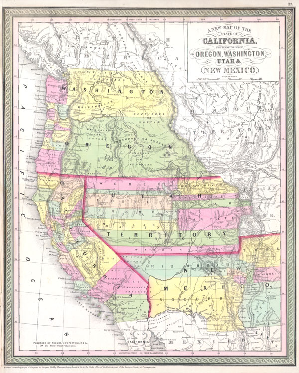
A New Map of the State of California, the Territories of Oregon, Washington, Utah & New Mexico.
1853 13 x 16 in (33.02 x 40.64 cm)
1853 13 x 16 in (33.02 x 40.64 cm)
Description
An extremely important 1853 map of the western United States by S. A. Mitchell Sr. Based upon Mitchell's own seminal 1846 Map of Texas and California. Depicts the United States west of the Rocky Mountains and predates the Gadsden Purchase. Tucson (Tueson) is located firmly in Mexico. 'Vegas' appears in an embryonic form. Lake Tahoe is not present, and Tule Lake is mistakenly enlarged. Also notes many of the important routes of the western Migration including, the Spanish Trail from Los Angeles to Santa Fe., Lt. Col. Cooke's Wagon Trail, Kearney's Route along the Rio Gila. Provides accurate and semi-accurate references to forts and Indian Tribes, especially in the southwest and in the Washington / Oregon Territories. Much of the cartography of the Great Basin is conjectural at best, but there are references to Fremont's Explorations. Indicates several alternative Mexico – US borders including those suggested by Bartlett and by Graham. Dated and copyrighted: 'Entered according to act of Congress in the Year of 1853 by Thomas Copwerthwait & Co. in the Clerk's Office of the District Court of the Eastern District of Pennsylvania.
Cartographer
Samuel Augustus Mitchell (March 20, 1792 - December 20, 1868) began his map publishing career in the early 1830s. Mitchell was born in Bristol, Connecticut. He relocated to Philadelphia in 1821. Having worked as a school teacher and a geographical writer, Mitchell was frustrated with the low quality and inaccuracy of school texts of the period. His first maps were an attempt to rectify this problem. In the next 20 years Mitchell would become the most prominent American map publisher of the mid-19th century. Mitchell worked with prominent engravers J. H. Young, H. S. Tanner, and H. N. Burroughs before attaining the full copyright on his maps in 1847. In 1849 Mitchell either partnered with or sold his plates to Thomas, Cowperthwait and Company who continued to publish the Mitchell's Universal Atlas. By about 1856 most of the Mitchell plates and copyrights were acquired by Charles Desilver who continued to publish the maps, many with modified borders and color schemes, until Mitchell's son, Samuel Augustus Mitchell Junior, entered the picture. In 1859, S.A. Mitchell Jr. purchased most of the plates back from Desilver and introduced his own floral motif border. From 1860 on, he published his own editions of the New General Atlas. The younger Mitchell became as prominent as his father, publishing maps and atlases until 1887, when most of the copyrights were again sold and the Mitchell firm closed its doors for the final time. More by this mapmaker...
Condition
Fine or perfect condition. Minor staining in right margin. Left margin narrow, as issued. Blank on verso.
References
Cf Moffat, R.M. Printed maps of Utah to 1900, 42. ; Phillips, 823.; Rumsey, 2832.001, 3802.001. Wheat, C.I. Maps of the Calif. gold region, 168; Wheat, C.I. Mapping the transmississippi West, 684.