This item has been sold, but you can get on the Waitlist to be notified if another example becomes available, or purchase a digital scan.
1892 Artero Map of the Caribbean, Four Voyages of Columbus
Caribbean-artero-1892$750.00

Title
Descubrimiento de América.
1892 (undated) 21 x 27 in (53.34 x 68.58 cm) 1 : 8115000
1892 (undated) 21 x 27 in (53.34 x 68.58 cm) 1 : 8115000
Description
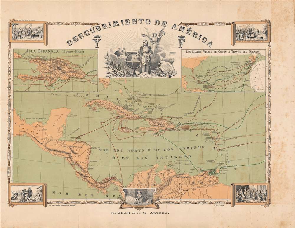
This is a rare and symbolically complex c. 1892 map of the Caribbean, produced by the Spanish geographer Juan de la Gloria Artero González to commemorate the quatercentenary (400-year anniversary) of Christopher Columbus' landing in the New World. Though broadly celebratory, Artero also highlights some of the more controversial aspects of Columbus' actions in the Americas, while maintaining the importance of the voyages as a hallmark event in the history of the Spanish nation.
A series of illustrations depict key events from the voyages, including (in roughly chronological order): at top-left, Columbus at La Rábida Friary, where he stayed after initially having his appeal to finance a voyage rejected by Ferdinand and Isabella; at top-center, Columbus in a heroic pose, pointing to Spain on a globe; at top-right, the departure of Columbus' first voyage from Palos (de la Frontera); at bottom-left, the first landing of Columbus in the New World, most likely at Guanahani (which he called San Salvador) in the Bahamas; at bottom-right, the reception of Columbus by Ferdinand and Isabella in Barcelona following his first voyage; and at bottom-center, the return of Columbus to Spain under arrest following his third voyage.
Two inset maps appear at top, one of the island of Hispaniola, and another of the Atlantic, including Spain. The names of important figures in the early history of Spanish America are written in the border. Most of these are Spanish explorers and conquistadors, including those who were crucial to Columbus' voyages but far less famous, such as 'Los Pinzones,' the Pinzón Brothers, as well as those who feuded with Columbus, such as Francisco de Bobadilla, who was sent to Hispaniola to investigate reports of Columbus' tyranny and mismanagement, and who had Columbus and his brothers arrested and dragged back to Spain. The names of important Taino chiefs (cacique) also appear, including Guatiguaná, the first such chief to organize a rebellion against the Spanish, and 'Queen' Anacaona, who had peaceful but tense relations with the Spanish but was apparently betrayed by them and murdered.
Aside from Columbus, other Spanish explorers and conquistadors are referred to, such as Ponce de Leon and Rodrigo de Bastidas, as well as the location and dates of the establishment of Spanish colonies. Longitude is measured unconventionally, using Madrid as the Prime Meridian, and noted at intervals of four degrees. The printing itself is also complex, combining engraving with lithography.
In Artero's case, the commemoration of Columbus and the discovery of the New World was a mark of Spanish national pride, which compensated for the decline of the once mighty empire. Obliquely referring to some of Columbus' misdeeds by including the Taino chiefs who he murdered, focusing on his imprisonment for misconduct (but not his later release and rehabilitation), and mentioning so many other figures in the early history of Spanish America may have been an attempt by Artero to somewhat lower the stature of the Genoese Columbus and rehabilitate the defunct empire.
A Closer Look
This is, at first glance, a relatively straightforward map of the West Indies tracking the four voyages of Columbus. However, a close examination reveals subtle and complex symbolism reflecting factual and moral ambiguities around the voyages. Artero inserts question marks around certain locations and does not show a continuous route for all the voyages, signifying uncertainty over their actual route, the result of only a small number of primary sources written by Columbus and his officers surviving.A series of illustrations depict key events from the voyages, including (in roughly chronological order): at top-left, Columbus at La Rábida Friary, where he stayed after initially having his appeal to finance a voyage rejected by Ferdinand and Isabella; at top-center, Columbus in a heroic pose, pointing to Spain on a globe; at top-right, the departure of Columbus' first voyage from Palos (de la Frontera); at bottom-left, the first landing of Columbus in the New World, most likely at Guanahani (which he called San Salvador) in the Bahamas; at bottom-right, the reception of Columbus by Ferdinand and Isabella in Barcelona following his first voyage; and at bottom-center, the return of Columbus to Spain under arrest following his third voyage.
Two inset maps appear at top, one of the island of Hispaniola, and another of the Atlantic, including Spain. The names of important figures in the early history of Spanish America are written in the border. Most of these are Spanish explorers and conquistadors, including those who were crucial to Columbus' voyages but far less famous, such as 'Los Pinzones,' the Pinzón Brothers, as well as those who feuded with Columbus, such as Francisco de Bobadilla, who was sent to Hispaniola to investigate reports of Columbus' tyranny and mismanagement, and who had Columbus and his brothers arrested and dragged back to Spain. The names of important Taino chiefs (cacique) also appear, including Guatiguaná, the first such chief to organize a rebellion against the Spanish, and 'Queen' Anacaona, who had peaceful but tense relations with the Spanish but was apparently betrayed by them and murdered.
Aside from Columbus, other Spanish explorers and conquistadors are referred to, such as Ponce de Leon and Rodrigo de Bastidas, as well as the location and dates of the establishment of Spanish colonies. Longitude is measured unconventionally, using Madrid as the Prime Meridian, and noted at intervals of four degrees. The printing itself is also complex, combining engraving with lithography.
Commemorating Columbus
This map was part a wider celebration of Columbus around the time of the quatercentenary of his landing in the New World. In the United States of America, this was evident in the 1893 Chicago World's Fair (the 'Columbian Exposition') and the first celebration of Columbus Day as a national holiday, meant to mollify Italian-Americans after the lynching of 11 Italians in New Orleans in 1891.In Artero's case, the commemoration of Columbus and the discovery of the New World was a mark of Spanish national pride, which compensated for the decline of the once mighty empire. Obliquely referring to some of Columbus' misdeeds by including the Taino chiefs who he murdered, focusing on his imprisonment for misconduct (but not his later release and rehabilitation), and mentioning so many other figures in the early history of Spanish America may have been an attempt by Artero to somewhat lower the stature of the Genoese Columbus and rehabilitate the defunct empire.
Publication History and Census
This map was prepared by Juan de la Gloria Artero, engraved by Juan Soler, and lithographed by Martí Campañá in Barcelona in or around 1892. In 1892, Artero also published Breve reseña de los cuatro viajes de Cristobal Colon: para servir a la inteligencia de los mapas (OCLC 1025674916), but the present map looks to have been a separate issue publication. It is only cataloged among the holdings of the Biblioteca Nacional de España and is scarce to the market.Cartographer
Juan de la Gloria Artero González (September 30, 1834 - January 19, 1903) was a Spanish geographer and historian. Born in Bullas, near Murcia, in southeastern Spain, he excelled in his studies and went to Madrid, where he earned a bachelor's and then a doctorate. He then became a professor and chair of the department of historical geography at the Universidad de Granada. While there he published a range of both introductory and comprehensive works on history and geography. Late in his career, he became the Dean of Philosophy and Letters at the Universitat de Barcelona before encountering health problems and retiring. More by this mapmaker...
Condition
Good. Moderate foxing, especially in right-hand margin. Some wear along fold lines.
References
OCLC 431791786.