1743 / 1771 Catesby Map of the American Southeast: Florida, Georgia and the Bahamas
CarolinaFlorida-catesby-1743-2$21,000.00

Title
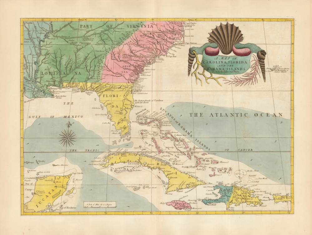
A Map of Carolina, Florida and the Bahama Islands with the Adjacent Parts.
1743 (undated) 17 x 23.75 in (43.18 x 60.325 cm) 1 : 5385600
1743 (undated) 17 x 23.75 in (43.18 x 60.325 cm) 1 : 5385600
Description
A beautiful 18th-century example of Mark Catesby’s 1743 map of the southeastern parts of North America. This map is considered one of the finest colonial-era maps of the American southeast. The present example is a 1771 third edition of the map.
On The Map
The map covers from the Mississippi River and from Cape Charles and Cape Henry to Jamaica, including all of North Carolina, South Carolina, Georgia, Florida, Louisiana, Cuba, Hispaniola, the Bahamas, Puerto Rico, and parts of the Yucatan. Among other features, it is notable for its remarkable cartouche, which includes shells, corals, and seaweeds indigenous to the Americas. Catesby was a naturalist, and the map was intended to provide context for his Natural History of Carolina, Florida and the Bahama Islands. The Natural History was the first illustrated work to focus on American flora and fauna, hailed by the secretary of the Royal Society, Cromwell Mortimer, as 'the most magnificent work I know since the art of printing has been discovered'.A Lens on the Colonial Southeast
Catesby's map represents an important reference for early forts, Indian tribes, English factories, and more in the southeast. The river systems of Georgia and Carolina are particularly impressive in their detail. These details were derived primarily from Henry Popple's 1733 wall map. Along with the Popple, this is the only map to present the Carolina details of John Barnwell’s manuscript map of 1722 - particularly in its delineation of Craven, Berkeley, and Coleton counties. The map's treatment of the Bahamas - also derived from Popple - is the earliest accurate depiction of the islands on so narrowly focused a map.Publication History
This map was most likely first engraved, either by William Henry Toms or by Catesby himself, after 1733 for inclusion in the 1743 second volume of Catesby's Natural History of Carolina, Florida and the Bahama Islands. (Examples have been found tipped into the 1731 first volume, to the confusion of later cataloguers no less illustrious than historian William R. Cummings.) The Natural History was published in three editions: the 1743 first edition of volume 2 (printed by William Innes), the 1754 edition by Charles Marsh, and the 1771 Benjamin White edition. Matters are complicated by the White edition's having continued in print well into the 19th-century, without the publisher having made any title page alteration. As early as 1800, the plates and the map began to appear printed on wove paper, and examples of these dated 1815 and even later have been identified.States and Editions
Catesby's map appeared in a single state: the printed image was unaltered throughout its publishing history. The map typically appears with original hand color with examples prior to 1771 exhibiting green color on both sides of the Mississippi, and with examples afterward colored blue to the west of the river (an alteration reflecting the 1763 Treaty of Paris, with lands to the west colored blue to reflect Spanish control). The present example is printed on laid paper, with an undated 'J. Whatman' watermark; this is consistent with examples assigned to the 1771 edition printed prior to 1795. We have identified the undated J. Whatman watermark appearing on works beginning as early as 1755, but Whatman added a date to their watermark as early as 1795. Early editions of the Catesby have been recorded with 'I. Taylor' watermarks, and paper watermarked 'I. Villedary' appears to be particularly associated with the 1743 first edition. This example being on Whatman paper tends to eliminate the early editions from our considerations. Since this example is on laid paper, older than 1795, we are satisfied that it is an 18th-century printing. Editions of Catesby's Natural History are well represented in institutional collections, but there are no separate examples listed in OCLC, and we see few in institutional online catalogs. The map is rare on the market.Cartographer
Mark Catesby (March 24, 1683 - December 23, 1749) was a British artist, scientist, and explorer active in the early to middle parts of the 18th century. He was born at Castle Hedingham, Essex, England, the son of a gentleman farmer and a prominent local politician. John Ray, a famed English naturalist and family, friend inspired Catesby to study natural history. When his father died, in 1712, he accompanied his sister, Elizabeth and her husband William Cooke, a member of the Virginia colony governor’s council, to Virginia. This was his first voyage to the Americas, where he remained for the subsequent 7 years, traveling through Appalachia and to some of the West India Islands, including Jamaica. During his travels he produced meticulous illustrations of the flora and fauna he encountered. On his return to London, the Royal Academy, then headed by Sir Isaac Newton, were so impressed with his work that they raised funds for a second voyage. Catesby returned to the America’s in 1722, arriving in Charleston. In the subsequent 4 years, he traveled throughout the Carolina, Florida, and the Bahamas, observing animal and plant life, and laying the groundwork for his seminal work, The Natural History of Carolina, Florida and the Bahama Islands, considered to be the first fully-illustrated natural history of North America. His work was highly influential, inspiring a new generation of natural historians, including Carl Linnaeus (1707 - 1778) and John James Audubon (1785 - 1851). Catesby died at his home in London where he was buried in the St. Luke Old Street churchyard, aged 66. More by this mapmaker...
Source
Catesby, M., Natural History of Carolina, Florida and the Bahama Islands, (London: White) 1771.
Condition
Excellent. On thick paper with a strong strike and generous margins. Original color consistent with 1771 edition, refreshed.
References
OCLC 20309168. Cumming, W., The Southeast in Early Maps, #210, page 25. Schwartz, S. and Ehrenberg, R., The Mapping of America, p.151-2.