This item has been sold, but you can get on the Waitlist to be notified if another example becomes available, or purchase a digital scan.
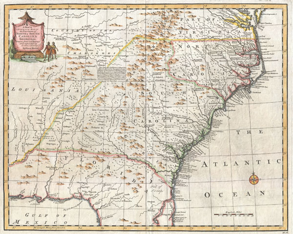
1747 Bowen Map of the Southeastern United States (Carolina, Georgia, Florida)
CarolinaGeorgia-bowen-1747$825.00

Title
A New and Accurate Map of the Provinces of North and South Carolina etc.
1747 (undated) 14 x 17.5 in (35.56 x 44.45 cm)
1747 (undated) 14 x 17.5 in (35.56 x 44.45 cm)
Description
This is Emmanuel Bowen's remarkable 1747 chart of the southeastern parts of North America. Covers from the mouth of the Chesapeake Bay to St. Augustine, FL, and from Louisiana to the Atlantic. Introduced in the second edition of Bowen's important Complete System of Geography, this map is loosely based on the cartographic conventions established by Popple's seminal 1733 map of the British Empire in America. Though Popple's map covered most of the continent, Bowen narrows his focus to the interesting area is today the American Southeast. The colonial boundaries of North Carolina, Virginia, South Carolina and Florida are clearly demarcated but, upon close examination, somewhat ambiguous in form. The coast lands, particularly in the Carolinas are well settled and exhibit considerable European development, however, only a short distance inland European settlements quickly give way to unexplored lands and the territories claimed by powerful American Indian nations. It is no mistake that Bowen chooses to include significant portions of both Spanish controlled Florida and French controlled Louisiana in the extreme southern and western parts of his maps. The French and Spanish had long been considered a serious threat to British hegemony in this region. In response to French incursions out of Louisiana the British forged a number of alliances with various indigenous groups, most specifically a 1745 treaty with the Cherokee and Catawaa tribes in what is today Kentucky and Tennessee. This alliance, of which Bowen makes a large notation in the center of his map, created a critical buffer zone between the French and British Empires in America. At the same time it opened Cherokee lands to British merchants and traders, as is evidenced by several English factories and forts appearing in the Cherokee dominated portion of what is ostensibly French Louisiana. Even so, it was from the south and the great Spanish bastion of St. Augustine that the British in America felt the greatest threat. It was partially in response to this and the need to develop the southern portions of Britian's American holdings, that lead to the founding of the Georgia colony in 1733. Just thirteen years after its founding in Savannah, we see the Georgia colony well defended through a series of fortifications and towns both along the coast and dotting the inland river ways. South of the border, in Florida, the Okefenokee Swamp separates Spanish and British dominions. Here two we can read a clear differentiation in colonizing philosophy. Where the British rely on treaties, settlement, and commercial development to further their interest in American Indian held lands, the Spanish dot the countryside with missions. In the northern part of Florida alone seven missions are identified: St. Francisco, St. Peter, St Mathew, St. John, St. Paul and St. Mark. All and all, this is an extraordinarily interesting and essential map for any serious collection focusing on the American Southwest. Published as plate no. 76 in the 1747 second edition of Bowen's Complete System of Geography.
Cartographer
Emanuel Bowen (1694 - May 8, 1767) had the high distinction to be named Royal Mapmaker to both to King George II of England and Louis XV of France. Bowen was born in Talley, Carmarthen, Wales, to a distinguished but not noble family. He apprenticed to Charles Price, Merchant Taylor, from 1709. He was admitted to the Merchant Taylors Livery Company on October 3, 1716, but had been active in London from about 1714. A early as 1726 he was noted as one of the leading London engravers. Bowen is highly regarded for producing some of the largest, most detailed, most accurate and most attractive maps of his era. He is known to have worked with most British cartographic figures of the period including Herman Moll and John Owen. Among his multiple apprentices, the most notable were Thomas Kitchin, Thomas Jeffreys, and John Lodge. Another apprentice, John Oakman (1748 - 1793) who had an affair with and eventually married, Bowen's daughter. Other Bowen apprentices include Thomas Buss, John Pryer, Samuel Lyne, his son Thomas Bowen, and William Fowler. Despite achieving peer respect, renown, and royal patronage, Bowen, like many cartographers, died in poverty. Upon Emanuel Bowen's death, his cartographic work was taken over by his son, Thomas Bowen (1733 - 1790) who also died in poverty. More by this mapmaker...
Source
Bowen, E., A complete system of geography. Being a description of all the countries, islands, cities, chief towns, harbours, lakes, and rivers, mountains, mines, &c. of the known world …, 1747 edition.
Condition
Very good condition. Wide clean margins. Original centerfold. Platemark visible. Blank on verso.
References
Cumming, W. P., The Southeast in Early Maps, 263. Williams, Gregory W. and Johnson, Allen S., Tar Heel Maps: Colony and State, 1590 - 1995, #9. Sellers, John R. and Van Ee, P., Maps and Charts of North America and the West Indies 1750 - 1789, #1380.