This item has been sold, but you can get on the Waitlist to be notified if another example becomes available, or purchase a digital scan.
1747 Bowen Map of the Southeastern United States (Carolina, Georgia, Florida)
CarolinaGeorgia-bowen-1747-2$1,875.00

Title
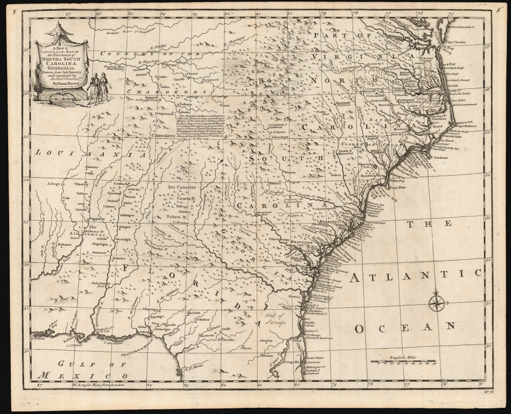
A New and Accurate Map of the Provinces of North and South Carolina etc.
1747 (undated) 14 x 17.5 in (35.56 x 44.45 cm) 1 : 2900000
1747 (undated) 14 x 17.5 in (35.56 x 44.45 cm) 1 : 2900000
Description
This is a strong example of Emmanuel Bowen's 1747 map of the Carolinas and Georgia. The map reveals the region against the rising hostilities that would soon culminate in the French and Indian War (1754 - 1763). Among its highlights are the defenses of the Georgia colony - then just 13 years old. It also notes the American Indian treaties and alliances that were the cornerstone of British colonial governance and commerce.
A Closer Look
The map spans from the mouth of the Chesapeake Bay to St. Augustine, Florida, and from Louisiana to the Atlantic. Introduced in the second edition of Bowen's important Complete System of Geography, this map delineates the colonial boundaries of North Carolina, Virginia, South Carolina, and Florida. The border with Florida, in particular, is ambiguous. Florida, after all, was Spanish territory at the time this map was produced. Indeed, Spain and Great Britain were at war (the War of Jenkins' Ear, which ran from 1739 to 1748). Several Spanish forts and 'lookouts' are noted on the north Florida coast, including the Spanish strongpoint at St. Augustine. One of the overriding reasons for the foundation of the Georgia colony was to establish a strong border with Spanish Florida. Just thirteen years after its founding in Savannah, the Georgia colony was well-defended through a series of fortifications and towns along the coast and dotting the inland riverways.The Interior
The map's clearest information can be found in the British coastal settlements, but the interior is also rich with interesting detail, particularly with respect to the powerful Native American nations found there. In particular, Bowen highlights the Cherokee and Catawba, and describes a 1745 treaty between them and Britain to create a buffer against the French to the west, and to protect the British colonies' flank against Spain. Britain's policy of creating alliances with Indigenous tribes on the frontiers was practical. This tactic also opened Cherokee lands to British merchants and traders, as is evidenced by several English factories and forts appearing in the Cherokee-dominated portion of what is ostensibly French Louisiana. In Florida, the Okefenokee Swamp separates Spanish and British dominions. Here we can read a clear differentiation in colonizing philosophy. Where the British relied on treaties, settlement, and commercial development to further their interest in American Indian-held lands, the Spanish converted the populace through Catholic missions. In the northern part of Florida alone, seven missions are identified: St. Francisco, St. Peter, St Mathew, St. John, St. Paul, and St. Mark.Sources
Cumming describes this map as a copy of the Carolina sheet of Popple's 1733 map of the British Empire in America, but while much of its content is sourced from the Popple, Bowen's map is not a rote copy and adds information not present on that map. Scanning the coastal areas of North Carolina, the present map bears more similarity to Edward Moseley's 1733 map than to the comparatively crude Popple. (For example, the lakes in the 'Dismal Swamp' north of Pamlico Sound resemble those on the Moseley and are not on the Popple. Cape Fear also more closely matches Moseley than Popple.)Publication History and Census
This map was introduced as plate no. 76 in the 1747 second edition of Bowen's Complete System of Geography. A further state was printed in 1752 for inclusion in Bowen's A Complete Atlas, unchanged except for the plate number. (This 1747 exhibits 'No. 76' at the lower right; the 1752 second state has the plate number 60 appearing at the lower left.) We see nine examples of the first 1747 issue listed in OCLC.Cartographer
Emanuel Bowen (1694 - May 8, 1767) had the high distinction to be named Royal Mapmaker to both to King George II of England and Louis XV of France. Bowen was born in Talley, Carmarthen, Wales, to a distinguished but not noble family. He apprenticed to Charles Price, Merchant Taylor, from 1709. He was admitted to the Merchant Taylors Livery Company on October 3, 1716, but had been active in London from about 1714. A early as 1726 he was noted as one of the leading London engravers. Bowen is highly regarded for producing some of the largest, most detailed, most accurate and most attractive maps of his era. He is known to have worked with most British cartographic figures of the period including Herman Moll and John Owen. Among his multiple apprentices, the most notable were Thomas Kitchin, Thomas Jeffreys, and John Lodge. Another apprentice, John Oakman (1748 - 1793) who had an affair with and eventually married, Bowen's daughter. Other Bowen apprentices include Thomas Buss, John Pryer, Samuel Lyne, his son Thomas Bowen, and William Fowler. Despite achieving peer respect, renown, and royal patronage, Bowen, like many cartographers, died in poverty. Upon Emanuel Bowen's death, his cartographic work was taken over by his son, Thomas Bowen (1733 - 1790) who also died in poverty. More by this mapmaker...
Source
Bowen, E., A Complete System of Geography. Being a description of all the countries, islands, cities, chief towns, harbours, lakes, and rivers, mountains, mines, etc. of the known world …, (London: Innys) 1747.
Condition
Very good. Invisible mend with no loss at upper left; else excellent with a sharp strike and generous margins.
References
OCLC 20309110. Rumsey 3733.059. Cumming, W. P., The Southeast in Early Maps, 263. Williams, Gregory W. and Johnson, Allen S., Tar Heel Maps: Colony and State, 1590 - 1995, #9. Sellers, John R. and Van Ee, P., Maps and Charts of North America and the West Indies 1750 - 1789, #1380.