This item has been sold, but you can get on the Waitlist to be notified if another example becomes available, or purchase a digital scan.
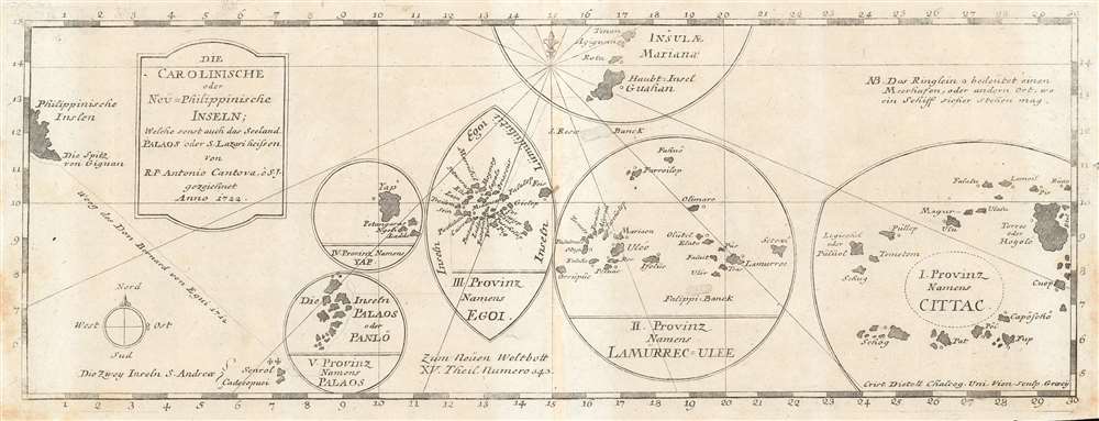
1728 Jesuit Map of the Caroline Islands
CarolineIslands-stocklein-1728$175.00

Title
Die Carolinische oder Neu=Philippinische Inseln; Welche sonst auch das Seeland Palaos oder S. Lazari heissen von R. P. Antonio Cantova, e S. J. gezeichnet Anno 1722.
1728 (dated 1722) 5.5 x 15 in (13.97 x 38.1 cm) 1 : 754105
1728 (dated 1722) 5.5 x 15 in (13.97 x 38.1 cm) 1 : 754105
Description
The earliest printed map of the Caroline Islands, produced by Joseph Stöcklein in 1728 for inclusion in Welt-Bott, his monumental collection of Jesuit missionary letters. The map was based on the reports of the Jesuit Juan Antonio Cantova (1686-1731), the first to establish a Christian mission in the Caroline Islands in 1722. The publication of this map pre-dates Cantova's 1731 establishment of his mission in Ulithi and subsequent death at the hands of the natives of the island Mogmog (among the island group marked III. Proving Names Egoi on the map.) Cantova's information, as reported in his 1722 letter to the confessor to the King of Spain, was derived from interviews with two separate groups of natives who were blown off course and shipwrecked at Guam, where Cantova was based. From these, Cantova learned their language and received the account of the islands which informs this map. The map's division of the archipelago into five distinct groups was derived from these interviews, as were the locations of safe anchorages was shown. The map also shows 1712 track of Bernard de Egui from the Philippines to the islands of S. Andrea, the first European contact with the Caroline Islands.
Publication History and Census
This map was printed by the Jesuit Joseph Stöcklein for inclusion in his 1728 Neuer Welt-Bott, a work chronicling the works of the Society of Jesus around the world. No examples of the separate map appear in OCLC. We are aware of occasional appearances of this map on the market.Cartographer
Joseph Stöcklein [Stoecklein] (July 30, 1676 – December 28, 1733) was a Jesuit priest, missionary, and scholar active in the late 17th and early 18th centuries. He was born in Oettingen, Germany and joined the Jesuit order in Vienna around 1700. He served as a priest in military encampments where he became popular as a preacher. Afterwards he became the head of the Jesuit library in Graz, Switzerland, a position he maintained for six years. During this tenure he began work on his opus, the Welt-Bott, a vast compilation of Jesuit missionary letters and narratives translated into vernacular German intended both to glorify the priesthood and share valuable information about the world. Today this work is exceedingly rare. More by this mapmaker...
Source
Stocklein, J. Neuer Weltbott. (Augsburg: Grätz) 1728.
Condition
Very good. Light toning in margins and at centerfold.