This item has been sold, but you can get on the Waitlist to be notified if another example becomes available, or purchase a digital scan.
1942 Visceglia World War II Italian Fascist Propaganda Map of the Pacific
CartaPacifico-visceglia-1942$237.50

Title
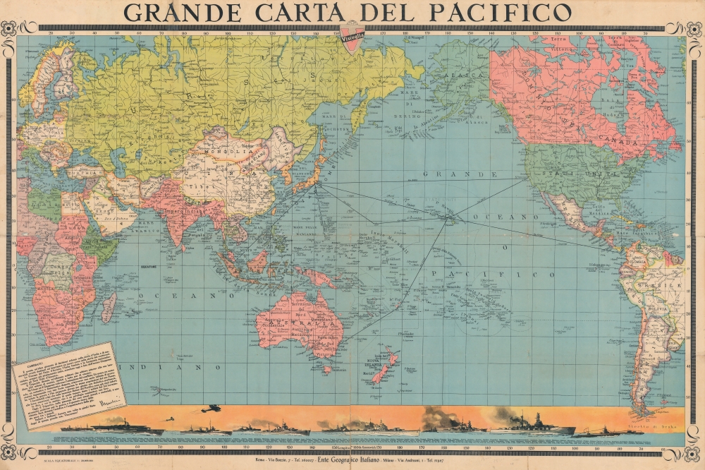
Grande Carta del Pacifico.
1942 (dated) 30.75 x 46.5 in (78.105 x 118.11 cm) 1 : 30000000
1942 (dated) 30.75 x 46.5 in (78.105 x 118.11 cm) 1 : 30000000
Description
Celebrating the Japanese attack on Pearl Harbor and centered over the vast expanse of the Pacific, this is a 1942 Visceglia World War II Fascist Italian map of the Pacific. Originating only days after the Japanese attack, the map is an exhortation from Mussolini to celebrate the achievements of their 'friends in the east'.
Subtle Propaganda
At first glance, it is unclear that this piece is unabashedly Fascist Italian propaganda. Geographically, only Germany's conquests and expansion in Eastern Europe (Austria, Czechoslovakia, and Poland) reflect the current state of war. Not even Manchukuo, the Japanese puppet state in Manchuria, is labeled. An illustration along the bottom border depicts Japan's navy and lists, by type of ship and by name, Japan's battleships (curiously first in the list considering this piece is celebrating the Japanese victory at Pearl Harbor), aircraft carriers, cruisers, destroyers, torpedo boats, and submarines. However, once one reads the textbox in the lower left, it this piece's goal becomes clear. A text from Mussolini dated December 11, 1941 (four days after the Japanese attack on Pearl Harbor) reads (in rough translation)Comrades!
This is another day of solemn decisions in the history of Italy and memorable events destined to give a new course in the history of the continents.
The Powers of the Pastto d'Acciaio, Fascist Italy and National Socialist Germany, more and more closely united, descend today to the side of heroic Japan against the United States of America. The Tripartite becomes a military alliance that deploys 250 million men around its flags, determined to do anything to win
Neither the Axis nor Japan wanted the extension of the conflict. A man, a single man, an authentic and democratic despot, through an endless series of provocations, deceiving with a supreme fraud the populations of his country, wanted the war and prepared it day by day with diabolical pertinacity.
The formidable blows that have already been inflicted on the American forces in the immense expanses of the Pacific show what kind of temper the soldiers of the Rising Sun are.
I say, and you appreciate, that it is a privilege to fight alongside them.
Today, the Tripartite alliance, in its moral and material superiority, is a powerful instrument for war and the sure garantor of victory. Tomorrow, it will be the architect and organizer of a just peace among peoples.
Italian men and women! Stand up once again! Be worthy of this great hour. We will win.
Mussolini 11-12-1941
A Closer Look
Depicting almost the entire world, Japan appears just to the left of center. Bold lines highlight the incredible distances between Tokyo and it’s the other powers in the region: 6,150 kilometers to Honolulu, 8,600 kilometers to San Francisco, and 2,600 kilometers to Guam. No direct line is drawn to Sydney, those distances are calculated via Honolulu and Fiji. Archipelagos and individual islands are labeled throughout the Pacific. Nations (and colonies) are identified worldwide, including Italian West Africa (Africa Orientale Italiana).Publication History and Census
This map was created and published by Visceglia and the Ente Geografico Italiano c. 1941 and was published as a supplement to the Guida Toponomastica Visceglia in January 1942. We note a single example cataloged in OCLC, at the University of Illinois at Urbana Champaign.Cartographer
Vincenzo Visceglia (January 30, 1903 - October 5, 1971) was an Italian cartographer and publisher. Born in Salandra, Visceglia began his university studies in engineering at the University of Naples, before moving to Rome and earning degrees in physics and mathematics from the University of Rome in 1928. He taught at a high school for a while before changing directions toward and founding the Visceglia Geographical Institute in 1929. The institute's first publication, The Toponymy Guide to Rome appeared in 1930. Visceglia continued to publish maps throughout the 1930s and 1940s (many supporting the fascist regime) and survived the war years. In the 1960s the Institute began publishing the Urban Atlas of Italy. Visceglia died at home in Rome after a long illness. The Visceglia Geographical Institute still publishes maps to this day. More by this mapmaker...
Condition
Average. Wear along original fold lines. Old repairs along original fold lines mostly on verso but a few recto repairs are evident. Slight loss at some fold intersections. Pinholing.
References
OCLC 1131699067.