This item has been sold, but you can get on the Waitlist to be notified if another example becomes available, or purchase a digital scan.
1771 Bonne Map of Mexico (Texas), Louisiana and Florida
CarteDuMexique2-bonne-1771$225.00

Title
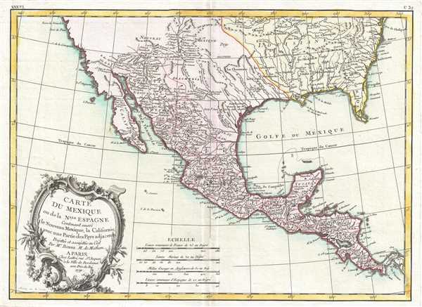
Carte du Mexique ou de la Nlle. Espagne Contenant aussi le Nouveau Mexique, la Californie, avec une Partie des Pays adjacents.
1771 (dated) 12.25 x 16.75 in (31.115 x 42.545 cm) 1 : 13300000
1771 (dated) 12.25 x 16.75 in (31.115 x 42.545 cm) 1 : 13300000
Description
This is a 1771 Rigobert Bonne map of Mexico and Florida. The map depicts the region from Baja California eastward to Florida and Carolina, and from the northwards mouth of the Chesapeake Bay to Panama. Bonne, being a very cautious cartographer, abandons many of the fictitious elements common to many period maps of this region, thus most unexplored areas are left blank. Being primarily a map of Mexico and the Spanish holdings in North America, this excellent map details the various Mexican states naming countless towns, villages, and haciendas. North of Spanish Mexico lies the vast and largely unknown American West, where numerous missionary stations along the Rio Bravo or Rivera du Nord (Rio Grande) are identified, extending well north into New Mexico towards Santa Fe. Several American Indian groups who traded with the French in Louisiana are also included. Another oddity is the rendering of southern Florida as an archipelago, a primitive attempt at describing the Everglades.
This map was drawn by Rigobert Bonne in 1771 for issue as plate no. C 32 in Jean Lattre's Atlas Moderne.
This map was drawn by Rigobert Bonne in 1771 for issue as plate no. C 32 in Jean Lattre's Atlas Moderne.
CartographerS
Rigobert Bonne (October 6, 1727 - September 2, 1794) was one of the most important French cartographers of the late 18th century. Bonne was born in Ardennes à Raucourt, France. He taught himself mathematics and by eighteen was a working engineer. During the War of the Austrian Succession (1740 - 1748) he served as a military engineer at Berg-op-Zoom. It the subsequent years Bonne became one of the most respected masters of mathematics, physics, and geography in Paris. In 1773, Bonne succeeded Jacques-Nicolas Bellin as Royal Cartographer to France in the office of the Hydrographer at the Depôt de la Marine. Working in his official capacity, Bonne compiled some of the most detailed and accurate maps of the period - most on an equal-area projection known erroneously as the 'Bonne Projection.' Bonne's work represents an important step in the evolution of the cartographic ideology away from the decorative work of the 17th and early 18th century towards a more scientific and practical aesthetic. While mostly focusing on coastal regions, the work of Bonne is highly regarded for its detail, historical importance, and overall aesthetic appeal. Bonne died of edema in 1794, but his son Charles-Marie Rigobert Bonne continued to publish his work well after his death. More by this mapmaker...
Jean Lattré (170x - 178x) was a Paris based bookseller, engraver, globe maker, calligrapher, and map publisher active in the mid to late 18th century. Lattré published a large corpus of maps, globes, and atlases in conjunction with a number of other important French cartographic figures, including Janvier, Zannoni, Bonne and Delamarche. He is also known to have worked with other European cartographers such as William Faden of London and the Italian cartographer Santini. Map piracy and copyright violations were common in 18th century France. Paris court records indicate that Lattré brought charges against several other period map publishers, including fellow Frenchman Desnos and the Italian map engraver Zannoni, both of whom he accused of copying his work. Lattré likes trained his wife Madame Lattré (né Vérard), as an engraver, as a late 18th century trade card promotes the world of 'Lattré et son Epouse.' Lattré's offices and bookshop were located at 20 rue St. Jaques, Paris, France. Later in life he relocated to Bordeaux. Learn More...
Source
Lattre, Jean, Atlas Moderne ou Collection de Cartes sur Toutes les Parties du Globe Terrestre, c.1778.
Condition
Very good. Even overall toning. Light wear along original centerfold. Original platemark visible. Blank on verso.
References
Rumsey 2612.074. Phillips (Atlases) 664. National Maritime Museum, 215.