
This item below is out of stock, but another example (left) is available. To view the available item, click "Details."
Details
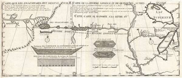
1703 Lahontan Map of the Great Lakes, Mississippi River, and Riviere Longue (first edition)
1703 (undated) $5,500.00
1703 Lahontan Map of the Great Lakes, Mississippi River, and Riviere Longue (first edition)
CarteQueLesGnacsitares2-lahonton-1703$2,750.00

Title
Carte que les Gnacsitares ont Dessine sur / Carte de la Riviere Longue et de quelques Autres qui se Dechargent dans le Grand Fleuve Missisipi.
1703 (undated) 11.5 x 26.5 in (29.21 x 67.31 cm) 1 : 6500000
1703 (undated) 11.5 x 26.5 in (29.21 x 67.31 cm) 1 : 6500000
Description
A foundational map of extreme importance and influence, this is the rare 1703 first edition of Baron Louis-Armand de Lom d'Arce de Lahontan's, seminal map of the westernmost Great Lakes, the Mississippi River, and an enigmatic tributary river, the Riviere Longue or Long River, extending westwards towards the Rocky Mountains. Although the Baron de Lahontan's map has been severely criticized and considered by some apocryphal, it exerted a profound influence on other influential mapmakers of the era including Herman Moll, John Senex, Henry Popple, and Guillaume Delisle.
Although framed as a single map, this is in fact two separate depictions separated by a dotted line: the right hand Carte de la Riviere Longue et de Quelques Autres (Map of the Long River and Some Others) covering from a recognizable Lake Michigan (Lac des Ilinois) and Lake Superior (Lac Superieur) westward beyond the Mississippi an unclear distance; and the Carte que les Gnacsitares ont Dessine Sur (Map drawn on the Gnacsitares) covering from some unknown point far west of the Mississippi to the Rocky Mountains and beyond. We will deal with each maps separately before addressing the document as a whole.
The first map is highly recognizable and is based upon earlier cartography combined with Lahontan's firsthand observations in the field during the Beaver Wars or Iroquois Wars. Being gifted with languages Lahontan had mastered Algonquin and so was sent with a detachment of French and indigenous American Indian troops to harass the Iroquois. He spent much of this time hunting and exploring the Upper Mississippi Valley, where he developed a romanticized impression of the local American Indians in line with the 'Noble Savage' trope. Lahontan was not trained as a cartographer or field surveyor, so his map is best understood as an amalgam of earlier maps intended as a platform to illustrate a loose interpretation of his own personal field observations. We can clearly recognize both Lake Superior and Lake Michigan. The Illinois River is evident, as is the Wabash. Based upon earlier maps he identifies the Missouri extending westward from the Mississippi near the bottom edge of the map and offers reasonable approximations of the Fox and Wisconsin Rivers.
The main focus of interest in the great river extending westward of from the Mississippi here identified as the Riviere Longue or Long River. This river would become Lahontan's greatest contribution to cartography. While some scholars have decried the Long River as a fabrication, a close study of the map as well as Lahontan's journals suggests strongly that Lahontan had actually discovered and explored, without knowing it, much of the upper Missouri River generations before Lewis and Clark would embark upon their own famous voyage. Lahontan may have followed the Minnesota River than portaged overland to meet the upper Missouri around Sioux City, mistaking it for the same river. His map and narrative describes encounters with the Eokoros, the Esanapes, the Gnacsitares, and the Mozeemlek. The Eokoros may in fact have been the Arikaras, the pronunciation of which may have sounded similar to Lahontan's ear. If so, both the location and Lahontan's description of Eokoros life, fits. Between lands of the Gnacsitares and Esnapes, Lohontan divides the map with a double dotted line, marking the division between his actual explorations and maps he derived from indigenous peoples.
Which brings our focus to the second or left most map presented here. This map continues to follow the Riviere Longue, but here the name has change to Riviere Morte (River of Death). The source of the Riviere Morte, high in the North-South mountain range Lahontan's indigenous informants describe as 'so high that one must pass an infinity of windings and turnings so that he may cross them.' This is surely an apt description of the Rocky Mountains. West of these mountains Mozeemlek captives described a great river flowing westward into the lands of the Tahuglauk, a people who lived near a great salt sea or lake, lived in plank houses, wore conical hats, and built great canoes. To us, this seems a very apt description of the Columbia River and the American Indians of the Northwest Coast, specifically the Tillamook, who fit this description exactly and whose name bears a phonetic resemblance to Tahuglauk.
Regardless of whether our speculations regarding the veracity of Lahontan's explorations have any merit, his narrative and this accompanying map proved enormously popular in Europe, being published in multiple editions. Lahontan's Long River itself must have seemed a godsend to European powers and their cartographers who, despairing of finding the Northwest Passage, dreamed of a river route through the continent to the Pacific, where beaver pelts and other furs could be loaded onto ships and sailed to the rich markets of China. Lahontan's map was directly incorporated into most new maps of North America published in the early to middle part of the 18th century, including maps by such influential cartographers as Guillaume Delisle, Herman Moll, John Senex, and others.
This map appeared in the 1703 first edition of Lahontan's Nouveaux Voyages de M. le Baron de Lahontan dans l’Amerique Septentrionale ('New Voyages of the Baron de Lahontan in North America'). There are two states of the first edition, this being the first, identifiable by the absence of a longitudinal scale at the top of the map. Subsequent reissues of this map were vastly reduced in size and scale.
Cartographer
Louis Armand Baron de Lahontan (June, 9 1666 – 1715) was a French nobleman and military officer best known for his extensive, and quite possibly fictional, travels in the Wisconsin and Minnesota region and the upper Mississippi Valley. Lahontan became the Baron Lahontan upon his father's death in 1674. Around 1683, at around 17, he joined the Troupes de la Marine and was sent to New France or Canada. After leading several failed military campaigns against English and Iroquois fortifications around the Great Lakes, Lahontan and his troops integrated with the local Algonquin Indians with whom they lived for several years. During this time he, supposedly, spent much of his time exploring the region, including a supposed expedition on a river he referred to as the "Rivière Longue". Though many consider his tale fanciful, he claims to have followed the river for a reasonable distance to a mountain range. Beyond the mountains, he was told by his American Indian guides, lay another river that flows westward and has an outlet into a salt sea. There are many debates regarding this, some consider it an early reference to the Missouri - Columbia River network later explored by Louis and Clark. Others believe he stumbled upon an early description of the Great Salt Lake. Regardless, his narrative which was published in Europe proved enormously popular and encouraged a number of attempts to search of the Longue River, which it was assumed, was part of a river network extending to the Pacific. The River and other aspects of Lahontan's cartography found its way into numerous influential maps of the period before being ultimately abandoned in the late 18th century. More by this mapmaker...
Source
Lahontan, Louis-Armand de Lom d'Arce, Nouveaux Voyages de M. le Baron de Lahontan dans l’Amerique Septentrionale, (Netherlands: La Haye) 1703.
Condition
Very good. Blank on verso. Wide margis. Original platem ark visible.
References
OCLC 36191430. Howes, W., U.S.iana (1650-1950): A Selective Bibliography in which are Described 11,620 Uncommon and Significant Books Relating to the Continental Portion of the United States, L-25. Karpinski, L. C., Bibliography of the Printed Maps of Michigan, 1804-1880, XL. Schwartz, S. and Ehrenberg, R., The Mapping of America, p.137, pl.81. Kershaw, K. A., Early Printed Maps of Canada, 298. Verner, Coolie and Stuart-Stubbs, B., The North Part of America, #20. Lemmon, A., Magill, J., and Wiese, J., Charting Louisiana: Five Hundred Years of Maps, #14. Buisseret, D., Mapping the French Empire in North America, #11. Wheat, C. I., Mapping of the Transmississippi West, 1540 – 1861, #86, v. 1, pp. 60-62. Mapp, P., The Elusive West and the contest for Empire, 2011. Fen, Elizabeth, Encounters at the Heart of the World: A History of the Mandan People, pp 41- 47.