This item has been sold, but you can get on the Waitlist to be notified if another example becomes available, or purchase a digital scan.
1950 Snow and Hill Map of Casco Bay, Portland Area, Maine
CascoBay-snow-1950-3$87.50

Title
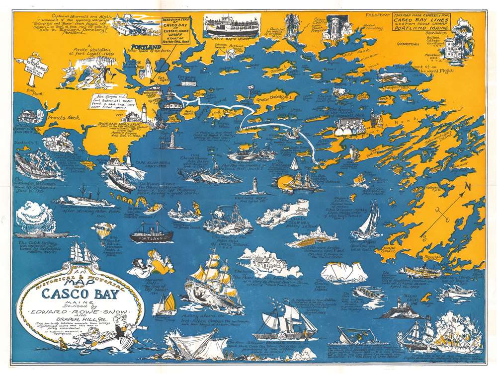
An Historical and Pictorial Map of Casco Bay Maine.
1950 (undated) 16.5 x 21.5 in (41.91 x 54.61 cm)
1950 (undated) 16.5 x 21.5 in (41.91 x 54.61 cm)
Description
This is a charming c. 1950 pictorial and historical map of Casco Bay, Maine by Edward Rowe Snow and Draper Hill, Jr. It covers Casco Bay, an inlet of the Gulf of Maine on the southern coast of Maine, from Prouts Neck (Scarborough Beach State Park) east as far as the southern portion of Georgetown Island, including the city of Portland. Throughout, the map notes towns, islands, capes, points and other topographical features.
Standing somewhere between these two map styles, our map combines the decorative aspects of both while reducing cartographic detail. It may be hard to get from A to B using this map, but its attractive design and decorative flourishes make it an excellent souvenir and memento of a wonderful Casco Bay vacation. A note in the title highlights the same: 'Any similarity between accurate town surveys or government charts and this map is purely coincidental. All historical material is copyrighted'.
Nautical Vignettes
The notable features of this map are the many pictographic and historical depictions throughout highlighting the region’s history and heritage. Several landmarks have been attractively illustrated, including the Portland Head Light, Munjoy Hill Observatory, Casco Castle near South Seaport, Seguin Light, and more. Some of the historical events recorded on the map are 'The Caleb Cushing was captured and burned by Confederate raiders, 1863', 'A pirate visitation at Fort Loyall – 1680', 'The monument A refuge for shipwrecked sailors - built in 1827', 'Skeletons unearthed at Jewells Island', 'A pot of gold discovered by John Winslow' and several others.'Figurative' or 'Pictorial' Maps
This map is considered a 'figurative map' or a 'pictorial map,' and reflects a style that first began to appear around 1910. As a map, its intention is not so much to provide direction as to illustrate the character, famous places, and historical appeal of Casco Bay. Cartographically speaking, this map style most likely draws its inspiration from late 19th century 'tourist maps' and 'railroad maps.' Tourist Maps, common to major cities in Europe (usually Paris or London), included profiles of notable buildings and monuments and were designed to help foreign tourists identify and navigate to the most important sights. 'Railroad Maps' are a related genre more common to the United States. During the latter part of the 19th century railroad boom, railroad companies began issuing decorative route maps extolling the virtues various regions and their accessibility by rail.Standing somewhere between these two map styles, our map combines the decorative aspects of both while reducing cartographic detail. It may be hard to get from A to B using this map, but its attractive design and decorative flourishes make it an excellent souvenir and memento of a wonderful Casco Bay vacation. A note in the title highlights the same: 'Any similarity between accurate town surveys or government charts and this map is purely coincidental. All historical material is copyrighted'.
Publication History and Census
This map was created and published by Edward Rowe Snow and Draper Hill, Jr. c. 1950. It was reissued for the Bicentennial Celebration in 1976. Uncommon.Cartographer
Edward Rowe Snow (August 22, 1902 – April 10, 1982) was an American author and historian. Born in Withrop, Massachusetts, Snow graduated from Harvard University and subsequently from Boston University with an M.A. Snow married Anna-Myrle Haegg on July 8, 1932 with whom he had one daughter. Snow worked as a high school teacher in Winthrop, Massachusetts for a time. He served as a first lieutenant with the XII Bomber Command during World War II and was wounded in North Africa in 1942. He was discharged in 1943 due to the wounds he received. Snow also worked as a daily columnist at The Patriot Ledger, a newspaper in Quiuncy, Massachusetts, from 1957 – 1982. He is widely remembered for his stories about pirates and other nautical subjects. Snow is the author of over forty books many shorter works. Over the course of his life, Snow was the author of over 100 publications, mostly concerning New England coastal history. He is also well remembered for maintaining the tradition of the 'Flying Santa' for over forty years (1936 – 1980). Begun in 1929, the 'Flying Santa' tradition was organized as a way to drop Christmas gifts out of airplanes to lighthouse keepers and their families along the New England coast. More by this mapmaker...
Condition
Very good.